Skara Brae › Maeshowe » Ancient origins
Articles and Definitions › Contents
- Skara Brae › Antique Origins
- Maeshowe › Ancient History
Ancient civilizations › Historical and archaeological sites
Skara Brae › Antique Origins
Definition and Origins

Skara Brae is a Neolithic Age site, consisting of ten stone structures, near the Bay of Skaill, Orkney, Scotland. Today the village is situated by the shore but when it was inhabited (c.3100-2500 BCE) it would have been further inland. Steady erosion of the land over the centuries has altered the landscape considerably and interpretations of the site, based upon its present location, have had to be re-evaluated in light of this. The name `Skara Brae' is a corruption of the old name for the site, `Skerrabra' or `Styerrabrae' which designated the mound which buried (and thereby preserved) the buildings of the village. The name by which the original inhabitants knew the site is unknown.
Traditionally, Skara Brae is said to have been discovered in 1850 CE when an enormous storm struck Orkney and dispersed the sand and soil which had buried the site. The landowner, one William Watt, noticed the exposed stone walls and began excavations, uncovering four stone houses. Recognizing the importance of his find, he contacted the Orcadian antiquarian George Petrie. Petrie began work at the site and, by 1868, had documented important finds and excavated further (presenting his progress at the April 1867 CE meeting of the Society of Antiquaries of Scotland). The Orcadian writer and historian, Dr. Ernest Marwick (1915-1977 CE) claimed that this story of the `discovery' of Skara Brae was “a complete fiction” (Orkeyjar, 1) and that it was long established there was an ancient site at the location. In a 1967 CE article, Marwick cited one James Robertson who, in 1769 CE, recorded the site in a journal of his tour of Orkney and claimed to have found a skeleton “with a sword in one hand and a Danish axe in the other” (Orkeyjar, 2). Whether any similar finds were made by William Watt or George Petrie in their excavations is not recorded. Petrie extensively catalogued all the beads, stone tools and ornaments found at the site and listed neither swords nor Danish axes. In fact, no weapons of any kind, other than Neolithic knives, have been found at the site and these, it is thought, were employed as tools in daily life rather than for any kind of warfare. Work was abandoned by Petrie shortly after 1868 CE but other interested parties continued to investigate the site.
EXCAVATIONS AT THE SITE FROM 1927 CE ONWARD HAVE UNCOVERED AND STABILIZED EUROPE ’S BEST PRESERVED NEOLITHIC AGE VILLAGE.
Following a number of these other antiquarians at Skara Brae, W. Balfour Stewart further excavated the location in 1913 CE and, at this point, the site was visited by unknown parties who, apparently in one weekend, excavated furiously and are thought to have carried off many important artifacts. What these artifacts may have been, however, is not recorded nor is it known whether the alleged thieves had anything to do with Stewart's party. In 1924 CE the site was placed under the guardianship of Her Majesty's Commissioners of Works by the trustees of the Watt estate and they undertook to secure the buildings against the toll being taken by exposure to the sea. In this same year, another gale force storm damaged the now excavated buildings and destroyed one of the stone houses. In an effort to preserve the site, and have it professionally excavated, the archaeologist and Edinburgh professor Vere Gordon Childe was called upon and arrived in Skaill with his associate J. Wilson Paterson. To preserve the site, a large sea wall was constructed throughout the summers of 1925 and 1926 CE and it was not until 1927 CE that Childe and Paterson were able to begin any serious work. In his 11 February 1929 CE report to the Society of Antiquaries of Scotland on the proceedings at Skara Brae, J. Wilson Paterson mentions the traditional story of the site being uncovered by a storm in 1850 CE and also mentions Mr. Watt as the landowner. He makes no mention of any public knowledge of the ancient village prior to 1850 CE and neither does Stewart. Excavations at the site from 1927 CE onward have uncovered and stabilized Europe's best preserved Neolithic Age village and it was declared a World Heritage site in 1999 by UNESCO. Today the village is under the administration of Historic Scotland.

Skara Brae
The builders of Skara Brae constructed their homes from flagstones and layered them into the earth for greater support, filling the space between the walls and the earth with middens for natural insulation. Every piece of furniture in the homes, from dressers to cupboards to chairs and beds, was fashioned from stone. Hearths indicate the homes were warmed by fire and each home would originally have had a roof, perhaps of turf, which, it is assumed, had some sort of opening to serve as a chimney. Even so, it is thought that the houses, which had no windows, would have been fairly smoky and certainly dark. As wood was scarce in the area, it is unknown what fueled the hearth. The theory that the people of Skara Brae waited by the shore for driftwood from North America seems untenable as, first, the village was not originally located by the sea and, second, since wood was so precious it seems unlikely it would have been burned. A wooden handle discovered at the site provides evidence that wood was most likely used in making tools rather than as fuel. Each house was constructed along the same design and many have the same sort of furniture and the same layout of the rooms. The village had a drainage system and even indoor toilets.
Artifacts uncovered at the site give evidence that the inhabitants made grooved ware, a style of pottery which produced vessels with flat bottoms and straight sides, decorated with grooves, and was indigenous to Orkney. This type of ceramic has led to the designation of the inhabitants of Skara Brae as Grooved Ware People and evidence of similar pottery has been found in other sites in Orkney such as Maeshowe. The Grooved Ware People raised cattle and sheep, farmed the land, and hunted and fished for food. They also crafted tools, gaming dice, jewellery, and other ornaments from bone, precious rock, and stone. According to Stewart, the 1867 CE excavations by Mr. Samuel Laing uncovered so many knives and scrapers that Laing thought he had discovered “a manufactory of such articles” (Stewart, 349). The Archeoastronomer Euan MacKie has claimed that Skara Brae was a community of astronomers and wise men who charted the heavens and bases this claim partly on stone balls found at the site engraved with rectilinear patterns. Stewart mentions stone and bone artifacts which he interpreted as being used in gaming and perhaps these balls were used for the same purpose. No one knows what the balls' purpose was and any claim can only be speculation. There is no evidence at the site, however, to support the claim that Skara Brae was a community of astronomers while a preponderance of evidence suggests a pastoral, agricultural village.

Stone furnishings of a house
In keeping with the story of Skara Brae's dramatic discovery in the 1850 CE storm, it has been claimed weather was also responsible for the abandonment of the village. A theory popular for decades claims the site was buried in sand by a great storm which forced the populace to abandon their homes and flee quickly. This theory further claims that this is how Skara Brae was so perfectly preserved in that, like Pompeii, it was so quickly and completely buried. J. Wilson Paterson, in his 1929 CE report, mentions beads among the artifacts uncovered. He writes that beads were “scattered over the surface of the floor.One group of beads and ornaments were found clustered together at the inner threshold of the very narrow doorway. These have been strung together and form a necklace. It would appear that the necklace had fallen from the wearer while passing through the low doorway” (Paterson, 228). While nothing in this report, nor evidence at the site, would seem to indicate a catastrophic storm driving away the inhabitants, Evan Hadingham in his popular work Circles and Standing Stones, suggests just that, writing, “It was one such storm and a shifting sand dune that obliterated the village after an unknown period of occupation. As was the case at Pompeii, the inhabitants seem to have been taken by surprise and fled in haste for many of their prized possessions…were left behind. One woman was in such haste that her necklace broke as she squeezed through the narrow doorway of her home, scattering a stream of beads along the passageway outside as she fled the encroaching sand” (p. 66). The beads mentioned by Paterson in no way provide support for such a scenario and the absence of human remains – or any other evidence of a cataclysm – suggests a different reason for the abandonment of the village. Evidence at the site substantiated during Graham and Anna Ritchie's archaeological excavations of the 1970's CE have disproved the cataclysm theory which rests largely on the supposition that Skara Brae stood by the shore in antiquity as it does today. The Ritchie's theory, which is shared by most scholars and archaeologists, is that the village was abandoned for unknown reasons and gradually became buried by sand and soil through the natural progression of time.
Maeshowe › Ancient History
Definition and Origins

Maeshowe (pronounced `maze-ow' or `maze-oo') is a large Neolithic chambered cairn, dating from between 3000-2800 BCE, in the Stenness parish of Orkney, Scotland. According to Dr. Berit Sanders, of Lund University, the name means `Meadow Mound' and comes from Old Scandinavian; the present location of both Maeshowe and the nearby site of the Maesquoy Standing Stones are thought to have originally been meadows (Orkneyjar.com). The construction of the cairn, and the long passage leading into it, has led scholars to also designate the site a passage grave even though no significant human remains (only traces of bone fragments and a skull portion) have been found at the site. Maeshowe is located in proximity to many other famous Neolithic sites in Orkney such as the Barnhouse Settlement and Barnhouse Stone, The Standing Stones of Stenness, The Ness of Brodgar, The Ring of Brodgar, The Watchstone, Cometstone, and The Unstan Cairn and, to the north-west, The Ring of Bookan and the village of Skara Brae.
The site was first excavated in July 1861 CE by the antiquarian James Farrer, on the recommendation of Mr. David Balfour, known for his work at Skara Brae, and others who also worked at Skara Brae such as Mr. George Petrie. Citing Petrie's measurements, Farrer described the exterior of the cairn thusly (metrics added): “The tumulus is about 92 feet (28 metres) in diameter, 36 feet (11 metres) high, and about 300 feet(91 metres) in circumference at the base. It is surrounded by a trench 40 feet (12 metres) wide, and varying in depth from 4 to 8 feet (1-2 metres). It is situated on the north side of the new road leading to Stromness from Kirkwall, being about 6 miles (9 km) from the former, and 9 (14 km) from the latter place. It is about 200 yards distant from the road and a mile and a half (2.4 km) from the Stones of Stenness” (guternberg.org). Farrer found the entrance passage blocked with rubble and, apparently at the suggestion of Petrie, dug down through the top of the mound (a choice which has been criticized by archaeologists since). At this time the mound was conical in shape but, when the site was taken under government care in 1910, a concrete roof was added (in part to close the cavity made by Farrer) and the mound shaped to its present form (Orkneyjar.com). Maeshowe is considered one of the finest examples of Neolithic architecture and has given its name to similarly constructed tombs stretching from Papa Westray and Sanday islands in the north down through mainland Orkney. The cairn was declared a World Heritage site in 1999 and is presently under the care of Historic Scotland.
As with many Neolithic sites, Maeshowe is aligned to the midwinter solstice and the setting sun at that time of year brightly illuminates the entrance passage and main chamber. That the cairn was built on the site of a much older structure is attested to by the find of a socket hole near the mound which suggests a stone circle once stood at the location. The trench surrounding the cairn seems similar to that surrounding other henges such as the nearby Ring of Brodgar. The nearby monolith known as the Barnhouse Stone is aligned directly with the entrance passage of Maeshowe and, at the winter solstice, the sun sets over the top of that stone monument to then illuminate the cairn. It is possible that the Barnhouse Stone was originally erected to perform the same function with a henge which once stood on the Maeshowe site and, if so, the builders carefully constructed the cairn to align to the earlier site of Barnhouse (built circa 3300). Alternately, it has been suggested, the Barnhouse Stone may have been erected during the construction of Maeshowe and the earlier structure at the site was a house or ritual site instead of a henge. Support for this theory comes from Structure Eight at the Barnhouse Settlement (built 2600 BCE) which seems to have been built for ritual purposes and, like Maeshowe, raised on a platform of clay. It has been suggested that Structure Eight may have been raised to replace whatever structure originally occupied the Maeshowe location.Whatever the original building, the current cairn is so precisely constructed that, twenty-two days before and after the winter solstice, the sun sets and then reappears from nearby Hoy's Ward Hill (directly in line with the Barnhouse Stone) to create what investigators of the phenomenon call `Solar Flashings' – flashes of light thrown into the entrance passageway and the main chamber. These flashes are not the prolonged illumination of the solstice and it has been suggested that the cairn was built purposefully to catch this light intermittently leading up to, and away from, midwinter to perhaps symbolize the coming of warmer, brighter, days.
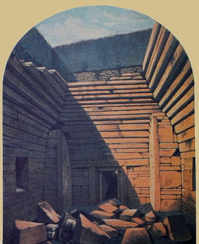
Maeshowe excavation 1861
The entrance passage, on the south-west side of the mound, runs 36 feet (11 metres) to the main chamber and includes the interesting feature of the so-called `blocking stone', a huge hewn rock which could be pulled from a recess in the wall to close off the passage, perhaps during rituals. The main chamber measures 13 feet (4.7 metres) with stone buttresses in the corners which once supported a corbelled roof (which the drawings of a Mr. Gibb of Aberdeen, who was a member of Farrer's 1861 CE expedition, show had fallen in before that time). Runic inscriptions (the largest single grouping found so far in the world) as well as the engraving of a dragon are cut in the walls of this chamber and date to the 12th century CE when a band of Norsemen took refuge in the cairn during a winter storm. This same group may have carried off whatever valuables or remains were housed in the main chamber or the three smaller ones which branch off from it (to the east, north, and west). The Orkeyinga Saga (written c. 1230 CE) describes the cairn being looted by the Norse Earl Harald Maddadarson and Ragnvald, Earl of More, sometime in the 12th century CE. As there is much in the Orkneyinga which scholars now consider legendary, it cannot be said with certainty that these particular men, or any men, broke in and looted the tomb. Farrer certainly seemed to think they did, writing in 1862 CE that, “[The Cairn has] undoubtedly been entered at some remote period, probably by the Northmen, who, as is well known, were not deterred by feelings either of religion or superstition, from opening and ransacking any place likely to repay them for their trouble. Whether they were the first to break into the building, or whether they found it in a state of comparative ruin, the natural result of great antiquity, can now only be matter of conjecture” (gutenberg. org).
Besides the testimony of the Orkneyinga Saga, the persistent claim that there were once valuables housed in the cairn is suggested by some of the runic graffiti which mentions a `great treasure' which was taken away from the site but, also, a great treasure buried close by the site. Whether there ever was any such treasure no one knows and the idea that Maeshowe once contained human remains, and attendant wealth for the afterlife, is pure speculation on the part of modern excavators based on these evidences and the excavators' assumptions of what the cairn may have once held. The only artifacts discovered by the 1861 CE party were bones of horses and a part of a human skull. No physical evidence exists to support the claim of a great treasure in the building nor even that it was a tomb. Further, it has been noted, the word `treasure' could have easily meant something quite different to an ancient community than it does to a more modern one. The Grooved Ware pot, found in Structure Eight of the Barnhouse Settlement, contained fourteen pieces of flint, a type of stone highly valued in Orkney owing to its rarity and “a quantity that would have been regarded as a treasure hoard at the time” (Orkneyjar.com).
The fact that the `blocking stone' at Maeshowe had to be pulled into place from inside, not outside, the entrance passage, suggests that it was used to seal off the cairn during rituals of some kind and the midwinter solstice alignment further supports the function of the site as ceremonial in nature. The location of the cairn, aligned to the Barnhouse Stone, in proximity to Structure Eight and, most significantly perhaps, to the recently excavated site of the Ness of Brodgar, which most certainly was a ritual complex, lends greater support to the theory that Maeshowe was used in this same capacity. As further excavation proceeds on the Ness of Brodgar, and surrounding areas which no doubt conceal more ancient structures, the original purpose of the cairn of Maeshowe may be better understood.
LICENSE:
Article based on information obtained from these sources:with permission from the Website Ancient History Encyclopedia
Content is available under License Creative Commons: Attribution-NonCommercial-ShareAlike 3.0 Unported. CC-BY-NC-SA License