Gortyn › The Inca Road System » Origins and History
Articles and Definitions › Contents
- Gortyn › Ancient History
- The Inca Road System › Antique Origins
Ancient civilizations › Historical places, and their characters
Gortyn › Ancient History
Definition and Origins
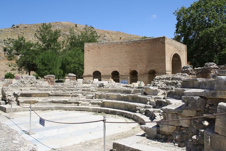
Gortyn is located on the Mesara plain of central Crete and was an important settlement throughout antiquity from the Minoanto Hellenistic periods. In Roman times the city went on to gain even more importance as the capital of the Roman province of Crete and Cyrene. The site today is particularly noted for the Gortyn Law Code, a lengthy wall inscription created in the 5th century BCE which is the earliest such example in Europe.
BRONZE AGE GORTYN
First settled in the Late Bronze Age, Gortyn was built on an acropolis and initially controlled by the Minoan palace of nearby Phaistos until it rose to prominence as the most important city-state in the region. Bronze Age Gortyn is also the setting of several important stories from Greek mythology. Europa was seduced here by Zeus when he took the form of a bull; their marriage taking place under an evergreen tree at the site. Gortyn is mentioned in Homer ’s Iliad as being a walled city and in the Odyssey where the Greeks, returning home from the Trojan War, are driven against the stormy coastline of southern Crete.
THE ARCHAIC PERIOD
In the 8th and 7th centuries BCE the city spread onto the plain near the Mylopotomos River. It was served by several nearby harbours, notably Matala and Lebena. The city acquired the usual agora, monumental sculpture and religious temples of a prosperous Greek polis or city-state. Two of the city's most important temples were dedicated to Apollo and Athena, the latter being regarded as the guardian of the city.
THE GORTYN LAW CODE IS THE EARLIEST SURVIVING LEGAL INSCRIPTION FROM ANYWHERE IN EUROPE.
THE CLASSICAL PERIOD & LAW CODE
Gortyn continued to flourish and created its own coinage from 470 BCE. Unfortunately, there are few remains of buildings from this period but there is one truly unique survivor. This is the famous Gortyn Law Code, which dates to c. 450 BCE.Inscribed on a curved porticus wall of marble blocks on the edge of the agora, this huge text spans 8 metres. It is divided into 12 columns and is in boustrophedon, that is alternate lines are read in opposite directions. The 600-line text, using the Doric alphabet and dialect, is almost complete and was clearly meant to be read by any member of the public. The Code describes articles of property and marital law, and is of special interest to historians for its details on the family and women's status. Also covered are rules concerning inheritance, debts, adoption, marriage, slavery, and sexual violence. It is the earliest surviving legal inscription from anywhere in Europe. Following the destruction of the supporting wall, the Code was actually dismantled and reassembled in the 1st century BCE. It was re-set in its original position although the communal space now functioned as a bouleuterion or meeting place for the city's council.
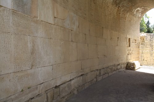
The Law Code of Gortyn, Crete
THE HELLENISTIC PERIOD
Gortyn continued to prosper in the Hellenistic period and, in the 3rd century BCE, it led a confederation of Cretan city-states against Knossos. Other indicators of Gortyn's increase in status included construction of an extra agora and a sanctuary to Demeter and Kore. With the support of Ptolemy IV Philopater of Egypt, Gortyn felt confident enough to take on rival Cretan powers such as Knossos and Phaistos in the Cretan Wars. Gortyn defeated Phaistos in the 2nd century BCE and then sided with old enemy Knossos to defeat Lyttos in c. 220 BCE.
THE ROMAN PERIOD
Rome began to take an interest in Cretan affairs in the 2nd century BCE, but Gortyn made the strategic error of giving sanctuary to Rome's great enemy Hannibal in 189 BCE. Then, switching policy and supporting Quintus Caecilius Metellus during his brutal invasion of Crete in the mid-1st century BCE, Gortyn seized the opportunity to increase its own power on the island and grow to an unprecedented size. The strategy worked as c. 27 BCE Augustus made Gortyn the capital of the Roman province Crete and Cyrene (in modern Libya).
Made the seat of the proconsul, the city also benefitted from a new complex for this purpose, the praetorium. Continuing to prosper in the following centuries the population grew to 300,000 and the city benefitted from Roman baths, theatres, a stadium, arena, odeion, and circus, as well as a much improved water system which included fountains, cisterns and aqueducts. A further indicator of Gortyn's status in the Roman world was the stationing of such prominent figures as future emperor Trajan, who served as the island's quaestor in 81 CE.
From the 3rd century CE Gortyn was involved in several episodes during the rise of Christianity, notably, in 249 CE when 10 Christian martyrs were killed in a nearby amphitheatre in a brutal wild animal hunt the Romans were so fond of staging. In 295-297 CE the province of Crete and Cyrene was divided and, although Gortyn remained the Cretan capital, it was now responsible to the prefect of Illyricum. The city fell into decline following a devastating earthquake in 365 CE after which it was abandoned as an administrative centre. Gortyn's fortunes did revive in the early Byzantine period with the construction of a new city further east where several basilicas were built, notably the 6th century CE Church of St. Titus (Hagios Titos), a follower of St. Paul who was martyred at the site. However, after another major earthquake in 670 CE Gortyn was definitively abandoned.
MAP
The Inca Road System › Antique Origins
Ancient Civilizations
The Inca road system formed a network known as the royal highway or qhapaq ñan, which became an invaluable part of the Inca empire, not only facilitating the movement of armies, people, and goods but also providing an important physical symbol of imperial control. Across plains, deserts, and mountains, the network connected settlements and administrative centres.Well-built and lasting, many roads included bridges, causeways, stairways, and also had small stations ( chaskiwasi ) and sometimes larger, more luxurious complexes ( tambos ) dotted along every 20 km or so, where travellers could spend the night and refresh.
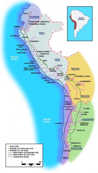
Inca Road System
THE INCA ROAD NETWORK
Inca roads covered over 40,000 km (25,000 miles), principally in two main highways running north to south across the Inca Empire, which eventually spread over ancient Peru, Ecuador, Chile, Bolivia, and Argentina. One highway ran down the coast, and the other wound through the highlands. Another important route ran east from Quito (Ecuador) across to Mendoza (Argentina), and there was also a major route along the plains of the northern coast. Criss-crossing these main roads were some 20 other secondary routes and many smaller trails besides. Roads were also built which went beyond Inca-controlled settlements and led to outside territory, perhaps to facilitate trade with, or military operations against, neighbouring peoples.Along some of the more important highways, milestones marked each Inca unit of distance, the topo, equivalent to 7 km.
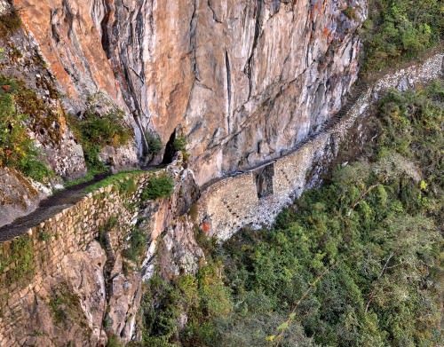
Although some Inca roads used older routes such as those built by the earlier Wari, Tiwanaku, and Chimu cultures, the Incas were also creative in their positioning of routes and were not afraid to cross new and unpopulated terrain. Inca engineers were also undaunted by geographical difficulties and built roads across ravines, rivers, deserts, and mountain passes up to 5,000 metres high.
Inca Road & Bridge
ENGINEERING METHODS & MATERIALS
Inca roads were built without the benefit of sophisticated surveying equipment using only wooden, stone, and bronze tools. As they were built in different geographical zones using local populations, the roads are, consequently, not uniform in construction design or materials. The width of most roads varies from one to four metres, although some could be much bigger, such as the 15-metre wide highway in the Huanuco Pampa province. Sometimes there are also two or three roads constructed in parallel, especially near the larger urban centres. Flattened road beds - often raised - were usually made using packed earth, sand, or grass. The more important roads were finished with precisely arranged paving stones or cobbles. Roads were typically edged and protected with small stone walls, stone markers, wooden or cane posts, or piles of stones. Drainage was provided by frequent drains and culverts, which drew off rainwater from the road surface, channelling it either along or under the road.When crossing wetlands, roads were often supported by buttress walls or built on causeways. Bridges of stone or reeds were also constructed to cover distances in a more direct route as were large, stone, llama-friendly staircases in mountainous terrain. There was even an appointed official, the Chaka Suyuyuq, responsible for inspecting the empire's bridges.
INCA ROADS ARE VERY OFTEN MORE ELABORATE & WELL-CONSTRUCTED THAN WAS ACTUALLY NECESSARY, NO DOUBT, SO AS TO IMPRESS TRAVELLERS & CONQUERED PEOPLES OF THE SUPERIORITY OF INCA CULTURE.
Generally, and despite their reputation for Roman -like long straight roads, Inca roads tended to follow natural contours as the straight stretches of road are rarely more than a few kilometres long. It is also noteworthy that Inca roads are very often more elaborate and well-constructed than was actually necessary. This attention to detail was almost certainly in order to impress travellers and conquered peoples of the superiority of Inca culture as felt by the lords of Cuzco.
Surely one of the most impressive sights and showcases for Inca engineering must have been the many rope suspension bridges which crossed perilous ravines. These were built using braids of reed or grass rope with wooden and fibre flooring.Perhaps the most famous crossed the Apurimac River near Cuzco and measured 45 metres in length. Suspension bridges were often built in pairs perhaps with one bridge for commoners and one for nobles. An alternative to such bridges was the oroya, a suspended basket which transported two or three people at a time over a greater distance than could be reached with a rope bridge. Local populations were given the responsibility of maintaining these perishable structures each year as part of their imperial tribute.
 INCA ROAD REST STATION
ROAD USERS
The extensive reach of the road network allowed the Incas to better move armies across their territories in order to further expand the empire or maintain order within it. Trade goods and tribute from conquered peoples - both goods and people - could also be easily transported to and from the major Inca centres, typically using llama caravans and porters (there were no wheeled vehicles). Inca administrative officials also travelled along the roads in order to dispense justice or maintain records such as local agricultural production, tribute quotas, and censuses. Ordinary people were not permitted to use the roads for private purposes unless they had official permission. They also sometimes had to pay tolls for the privilege, especially at bridges.
Another interesting feature of Inca roads was the use of runners ( chaski or chasquis ). Moving as fast as they could, they operated in relays, passing information to a fresh runner stationed every six to nine kilometres. However, it was not only messages that were carried between population centres but also such perishable items as fresh fish and seafood for the tables of Inca nobles. With this system, information (and fish) could travel up to 240 km in a single day. Messages carried over long distances would have involved hundreds of oral exchanges, and to preserve the correct meaning of the original message, quipu - a coded assembly of strings and knots - were probably used to help the memory of the runners.
LEGACY
Many sections of the Inca road network survive today and are still used by pedestrians, especially near such sites as Machu Picchu, where large stone stairways and bridges give access to the site for modern tourists. In addition, some of the original Inca routes have had modern roads built directly over them, illustrating the skills and vision for crossing terrain and distances possessed by Inca engineers and road builders.
LICENSE:
Article based on information obtained from these sources:with permission from the Website Ancient History Encyclopedia
Content is available under License Creative Commons: Attribution-NonCommercial-ShareAlike 3.0 Unported. CC-BY-NC-SA License