Ashoka the Great › The Lullubian Rock Relief » Ancient origins
Articles and Definitions › Contents
- Ashoka the Great › Who Was
- The Lullubian Rock Relief of Darband-i Basara › Antique Origins
Ancient civilizations › Historical and archaeological sites
Ashoka the Great › Who Was
Definition and Origins
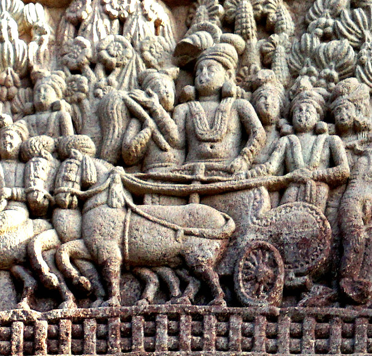
Emperor Ashoka the Great (sometimes spelt Aśoka) lived from 304 to 232 BCE and was the third ruler of the Indian Mauryan Empire, the largest ever in the Indian subcontinent and one of the world's largest empires at its time. He ruled form 268 BCE to 232 BCE and became a model of kingship in the Buddhist tradition. Under Ashoka India had an estimated population of 30 million, much higher than any of the contemporary Hellenistic kingdoms. After Ashoka's death, however, the Mauryan dynasty came to an end and its empire dissolved.
ASHOKA'S RULE
In the beginning, Ashoka ruled the empire like his grandfather did, in an efficient but cruel way. He used military strength in order to expand the empire and created sadistic rules against criminals. A Chinese traveller named Xuanzang (Hsüan-tsang) who visited India for several years during the 7th century CE, reports that even during his time, about 900 years after the time of Ashoka, Hindu tradition still remembered the prison Ashoka had established in the north of the capital as “Ashoka's hell”.Ashoka ordered that prisoners should be subject to all imagined and unimagined tortures and nobody should ever leave the prison alive.
During the expansion of the Mauryan Empire, Ashoka led a war against a feudal state named Kalinga (present day Orissa) with the goal of annexing its territory, something that his grandfather had already attempted to do. The conflict took place around 261 BCE and it is considered one of the most brutal and bloodiest wars in world history. The people from Kalinga defended themselves stubbornly, keeping their honour but losing the war: Ashoka's military strength was far beyond Kalinga's.The disaster in Kalinga was supreme: with around 300,000 casualties, the city devastated and thousands of surviving men, women and children deported.
AFTER THE WAR OF KALINGA, ASHOKA CONTROLLED ALL THE INDIAN SUBCONTINENT EXCEPT FOR THE EXTREME SOUTHERN PART.
What happened after this war has been subject to numerous stories and it is not easy to make a sharp distinction between facts and fiction. What is actually supported by historical evidence is that Ashoka issued an edict expressing his regret for the suffering inflicted in Kalinga and assuring that he would renounce war and embrace the propagation of dharma. What Ashoka meant by dharma is not entirely clear: some believe that he was referring to the teachings of the Buddha and, therefore, he was expressing his conversion to Buddhism. But the word dharma, in the context of Ashoka, had also other meanings not necessarily linked to Buddhism. It is true, however, that in subsequent inscriptions Ashoka specifically mentions Buddhist sites and Buddhist texts, but what he meant by the word dharma seems to be more related to morals, social concerns and religious tolerance rather than Buddhism.
THE EDICTS OF ASHOKA
After the war of Kalinga, Ashoka controlled all the Indian subcontinent except for the extreme southern part and he could have easily controlled that remaining part as well, but he decided not to. Some versions say that Ashoka was sickened by the slaughter of the war and refused to keep on fighting. Whatever his reasons were, Ashoka stopped his expansion policy and India turned into a prosperous and peaceful place for the years to come.

Greek and Aramaic inscriptions by king Ashoka
Ashoka began to issue one of the most famous edicts in the history of government and instructed his officials to carve them on rocks and pillars, in line with the local dialects and in a very simple fashion. In the rock edicts, Ashoka talks about religious freedom and religious tolerance, he instructs his officials to help the poor and the elderly, establishes medical facilities for humans and animals, commands obedience to parents, respect for elders, generosity for all priests and ascetic orders no matter their creed, orders fruit and shade trees to be planted and also wells to be dug along the roads so travellers can benefit from them.
However attractive all this edicts might seem, the reality is that some sectors of Indian society were truly upset about them.Brahman priests saw in them a serious limitation to their ancient ceremonies involving animal sacrifices, since the taking of animal life was no longer an easy business and hunters along with fishermen were equally angry about this. Peasants were also affected by this and were upset when officials told them that “chaff must not be set on fire along with the living things in it”.Brutal or peaceful, it seems that no ruler can fully satisfy the people.
SUPPORT FOR BUDDHISM
The Buddhist tradition holds many legends about Ashoka. Some of these include stories about his conversion to Buddhism, his support of the monastic Buddhist communities, his decision to establish many Buddhist pilgrimage sites, his worship of the bodhi tree under which the Buddha attained enlightenment, his central role organizing the Third Buddhist Council, followed by the support of Buddhist missions all over the empire and even beyond as far as Greece, Egypt and Syria. The Buddhist Theravada tradition claims that a group of Buddhist missionaries sent by Emperor Ashoka introduced the Sthaviravada school (a Buddhist school no longer existent) in Sri Lanka, about 240 BCE.
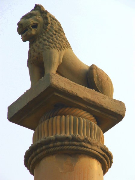
Ashoka's pillar
It is not possible to know which of these claims are actual historical facts. What we do know is that Ashoka turned Buddhism into a state religion and encouraged Buddhist missionary activity. He also provided a favourable climate for the acceptance of Buddhist ideas, and generated among Buddhist monks certain expectations of support and influence on the machinery of political decision making. Prior to Ashoka Buddhism was a relatively minor tradition in India and some scholars have proposed that the impact of the Buddha in his own day was relatively limited. Archaeological evidence for Buddhism between the death of the Buddha and the time of Ashoka is scarce; after the time of Ashoka it is abundant.
A PARTICULAR STORY TELLS THAT ASHOKA BUILT 84,000 STUPAS.
Was Ashoka a true follower of the Buddhist doctrine or was he simply using Buddhism as a way of reducing social conflict by favouring a tolerant system of thought and thus make it easier to rule over a nation composed of several states that were annexed through war? Was his conversion to Buddhism truly honest or did he see Buddhism as a useful psychological tool for social cohesion? The intentions of Ashoka remain unknown and there are all types of arguments supporting both views.
ASHOKA'S LEGACY
He did with Buddhism in India what Emperor Constantine did with Christianity in Europe and what the Han dynasty did with Confucianism in China : he turned a tradition into an official state ideology and thanks to his support Buddhism ceased to be a local Indian cult and began its long transformation into a world religion. Eventually, Buddhism died out in India sometime after Ashoka's death, but it remained popular outside its native land, especially in eastern and south-eastern Asia. The world owes to Ashoka the growth of one of the world's largest spiritual traditions.
The Lullubian Rock Relief of Darband-i Basara › Antique Origins
Ancient Civilizations
History doesn't repeat itself, but it does rhyme. (Mark Twain)
Darband-i Basara (the Pass of Basara) is a narrow natural gorge which transects the anticlines of the upper part of the Qaradagh Mountain Range. The elevation is about 605 meters above the sea level. A stream descends and passes through the gorge from the north-east to the south-west. The gorge (35°26'39.56"N, 45° 9'20.91"E) is within the western borders of the Governorate of Sulaymaniyah (Iraqi Kurdistan), about 27 km south-west from the well-known Darband-i Bazian.

Darband-i Basara and its Rock Relief
NAME & SIGNIFICANCE
The origin of the word “Basara” (Kurdish: دەربەندى باسەڕە; Arabic: دربند باسره) is disputed. Literally translated from modern Kurdish language, the phonetic word Basara would mean “the cold wind”. The late Taufiq Wahby (1891-1984 CE) suggested that Basara is an old Indo-Iranian word and reads Vasarah ( Sanskrit : 'thriving' or 'radiant'), which is also found in Old Persian as Vaharah and means 'spring'. However, there is a small village near Ranya (north-west of Sulaymaniyah) called Basara. In addition, one of the local tribes bears the name of Basara. There are various English spelling forms of Darband-i Basara: Darband Bāsahrah, Darband-i Bāsara, Darband Basahrah, and Derbend Baseṟe.
DARBAND-I BAZIAN IS CONSIDERED THE MAIN GATE THROUGH WHICH ONE CAN ENTER THE WESTERN PART OF THE MODERN CITY OF SULAYMANIYAH.
Unlike Darband-i Bazian, which is somewhat dry and hot in the summer and lacks water resources, Darband-i Basara is cold, with a very refreshing scent of wind and water continuously flowing through it. The narrow path and the relatively high flanking terrain would prevent the rays of the sun from reaching the area after midday. Darband-i Bazian is considered the main gate through which one can enter the western part of the modern city of Sulaymaniyah. It had played a critical role in the military history of the region for millennia. Any army must pass through it in order to reach the western cities of the Zagros Mountain Range and then to penetrate deeply into the western Iranian regions. Cuneiform tablets tell us that the Assyrian king Ashurnasirpal II (r. 884-859 BCE) in the year 881 BCE mobilized his well-trained and well-equipped imperial army to suppress a revolt in Zamua, the Land of the Lulubis (Lullubis; modern-day Sharazur as its core). The chiefs of Zamua's uprising fortified the narrow Darband-i Bazian, by constructing a large and thick wall, in a desperate attempt to ward off the overwhelming Assyrian wave. They failed, and the Assyrians conquered the area and killed approximately 1400 soldiers who were defending the walls of Darband-i Bazian. There have been many battles in and around Darband-i Bazian since then; the last military conflict was in the early 20th century CE between Kurdish leader Sheikh Mahmud Barzinji (who had revolted against the British occupation and the newly formed Iraqi Government) and two British brigades.
During the Ottoman-Persian war in 1733 CE, the Ottoman army fought the army of Nader Shah at Darband-i Bazian. The Persians did not march through the usual roads but very probably took the path of Darband-i Basarah (which was unknown to the Ottomans and therefore it was not fortified) to reach the western region of Darband-i Bazian (behind the Turkish army), and they took the Ottomans by surprise. Nader Shah won a decisive victory and killed the famous Ottoman army officer Topal Osman Pasha.
ROCK RELIEF REPLICA
As a result of an unfinished dam-building project in the 1990s CE, former director of the Antiquities of Sulaymaniyah, Mr. Adel Majeed, visited the gorge to examine a relief carved on the face of an anticline. The construction of the dam did not stop because of this relief, and the surrounding area underwent no formal excavation. In early 2002 CE, the Directorate of Sulaymaniyah Antiquities decided to make a replica of the relief as the operation of the dam would result in the relief being submerged and lost for good. The replica is in the storehouse of the Sulaymaniyah Museum and is not on display.

The Lulubian Rock Relief of Darband-i Basara

Darband-i Basara Rock Relief
According to Mr. Hashim Hama Abdullah, director of the Sulaymaniyah Museum, few people know about the relief; mainly those who participated in the process of making the replica. Of course, local archaeologists and historians also have an idea about it, however, while there are numerous geology-related articles addressing the gorge of Basara, none of them mentions the presence of a nearby relief. Someone had used a modern white paint to write his name (in Kurdish language: ئارام زوراب سه رده شت) on the surface of the rock; some letters of his name cover the relief, and it is unclear whether he intentionally vandalized the relief or it was just a coincidence and he did not glimpse the relief itself.
Dr. Kozad Muhammed Ahmad, assistant professor and head of the department of archaeology at the College of Humanities of the University of Sulaymaniyah, told me that, when he was an undergraduate student at the Baghdad College of Arts in 1988 CE, one of his friends from Chamchamal told him about this rock relief. Prior to the Kurdish uprising in 1991 CE against Saddam's Regime, this region was a no man's land, part of the Anfal's Military Campaign. In 1993 CE, Dr. Kozad and a local TV team visited the relief and made a short documentary about it. Unfortunately, the archive of this TV network (and all of its accompanying images) was lost in the mid-1990s CE during the internal Kurdish conflict.
THE REAL ROCK RELIEF
The details of the replica are inconspicuous and vague, and so on March 8, 2018 CE, together with Hashim and my friend Othman Towfiq, a lecturer at the department of archaeology, University of Sulaymaniyah, we headed to Darband-i Basara. The trip was through the Sulaymaniyah-Kirkuk road and Tasluja, and via the village of Allayi, we headed southward passing through several villages, including Mahmudia and Khewata. At the confluence of Darband-i Sutao, Sola, and Dailaizha, we turned westward and southward, and we finally arrived at the outlet of the Darband-i Basara.

Darband-i Basara
Google E arth image of Darband-i Basara showing the location of the Lullubian rock relief (black arrow). Sulaymaniyah Governorate, Iraqi Kurdistan.

Darband-i Basara Rock Relief

Darband-i Basara Rock Relief
The rock relief of Darband-i Basara at the southwestern rocky limb of the Qaradagh's anticline. The overlying modern white paint is a Kurdish name (someone wrote his name on it, unknown date). Some modern yellow pain can also be seen. There are two reliefs. The one within the sunken square is the main scene. Another one (greatly weathered) is on the right. Water was poured on the relief to highlight its details. March 8, 2018 CE. Sulaymaniyah, Iraqi Kurdistan. Exclusive photo. Photo © Osama SM Amin.
There are two reliefs, not one, on the face of the southwestern rocky limb of the Qaradagh's anticline. They are about 2.5 m above the road level. The main relief was carved within a roughly square area and another very weathered relief has survived nearby; it lies to the right side, a little bit above the right border of the square.

The Lulubian Rock Relief of Darband-i Basara
This is the rock relief of Darband-i Basara. Three figures can be recognised within the sunken square area. The overlying white and yellow paints are modern. The surface of the relief was poured with water in order to highlight the details (the surface was very dry and the sun was very shiny). March 8, 2018. Sulaymaniyah, Iraqi Kurdistan. Exclusive photo. Photo © Osama SM Amin.
The scene was carved as a sunken relief, within a roughly square-shaped area, and its margins were demarcated clearly; 60 cm in width and 52 cm in height. On the right, a standing figure (47 cm in height and 3 cm in depth), wearing a horned pointed helmet, stands on the lower side (or edge) of the square. It is unclear whether this deity is a male or a female. There are no discernable facial features. The feet are pointing to the left, and therefore the deity looks to the left. The deity wears a long dress, from the neck down to the ankles. It is not obvious whether the lower half of the gown is ruffled, tiered, or smooth. The deity's arms are outstretched forward and are a little bit inclined downward; they appear to embrace a human figure in front of it, at the lower chest.
A human figure was carved in front of the deity; this figure does not touch the ground. It is presumed to be a male, wearing a rolled-up head cap (similar to the Ur III ones). Once again, the facial features are indistinguishable, but he looks to the right, towards the deity. His arms are also outstretched forward and seem to hold the deity at his shoulders or lower neck. The pelvic area of the human figure is in a very close proximity to the deity, almost touching the latter. The human figure's extended legs cuddle the deity's waist. Its height, from the tip of the head cap to the lowest point of the pelvis is about 17 cm. The oval-rounded hole within the relief at the abdomen of the deity might well have been naturally created as a result of weathering or it may be man-made to affix something. Behind the deity, and at the right lower corner of the square, there is a trace of what appears to be a small kneeling human figure with raised arms and clasped hands. No remnant evidence of any rope connecting the deity to this kneeling figure can be recognised. Another hole in the rock can be seen at the ankle of the kneeling figure. The back of the deity faces Darband-i Basara; therefore, the deity looks away from the outlet of the gorge.There are no traces of any original paint; the white and yellow we can see are modern.

Darband-i Basara Rock Relief
The lower part of this relief has survived the severe and long-standing weathering effect. It was carved on the right side of the main relief of Darband-i Basara. The lower body (dress and feet) of a standing figure looking to the right can be recognised.The white and yellow paints are modern. March 8, 2018 CE. Sulaymaniyah, Iraqi Kurdistan. Exclusive photo. Photo © Osama SM Amin.
The area a little bit above and to the right of the aforementioned relief was smoothed out and another low-relief was carved.However, there are no clear-cut boundaries, and only the lower half of a standing figure, looking to the gorge and wearing a long ankle-length gown can be recognised. The details and purpose of this second relief are enigmatic. It is debatable whether it was added later on, beside the main relief, or it was carved first; it is unlikely that both were carved simultaneously.
INTERPRETATION
What was the intention behind carving those reliefs? No inscription of any kind was found. Were there any inscriptions and were they erased deliberately or naturally through weathering? The iconography and the depicted figures are somewhat unusual. Local scholars disagree whether the deity is engaging in a sexual relationship with the human being or not. This explicitly depicted coitus between a divine creature and a human being might reflect some sort of sacredness or be granted impunity. The latter observation was coined by Mr. Mu'atasim Rashid and Mr. Adel Majeed.
The deity's prominently pointed helmet and the rolled-up head cap of the human figure, as well as the kneeling figure, are reminiscent of the Lullubian rock relief of Anubanini at Sarpol-e Zahab. Dr. Kozad and Mr. Hashim Hama Abdullah agree with this notion. Therefore, the relief is interpreted as a Lulubian (Lullubian) one and dates to the late 3rd millennium to early 2nd millennium BCE. However, Dr. Kozad, whose PhD thesis was about the “Beginnings of Ancient Kurdistan”, also suggested that Darband-i Basara was close to the Gutians' territory and that the relief might well have been a Gutian one. This would have dated the relief to the late 3rd millennium BCE.
History tells us that this gorge was an important, yet relatively unknown, road. Does the relief depict the victors and the vanquished theme? What happened here 4000 years ago? Unlike other rock reliefs in Iraqi Kurdistan (which were carved high on the mountains), this relief was on the side of the road where anyone could spot it easily. Was it painted vibrantly? An important point to highlight is that the relief has escaped vandalism and iconoclasm in spite of being easily accessible.
Acknowledgements
A special gratitude goes to Mr. Hashim Hama Abdullah and Dr. Kozad Muhammed Ahmad for their kind help and cooperation.
LICENSE:
Article based on information obtained from these sources:with permission from the Website Ancient History Encyclopedia
Content is available under License Creative Commons: Attribution-NonCommercial-ShareAlike 3.0 Unported. CC-BY-NC-SA License