Viking Ships › Urartu Civilization › Bronze Age Sicily » Origins and History
Articles and Definitions › Contents
- Viking Ships › Origins
- Urartu Civilization › Origins
- Bronze Age Sicily › Origins
Ancient civilizations › Historical places, and their characters
Viking Ships › Origins
Definition and Origins
Viking ships were built by the Scandinavians during the Viking Age (c. 790 CE - c. 1100 CE) and were used both within Scandinavia and beyond for purposes ranging from being the most important means of transport to trade and warfare. Viking expansion, moreover, would not have been possible without ships. One of the most famous images connected with the Vikings is that of the dragon-headed longships, red-and-white striped sails giving it deadly speed and carrying its bloodthirsty warriors to their destinations of plunder. However, Viking ships came in many different forms, among which there were big-bellied cargo ships and, indeed, the speedy longships which facilitated raiding and gave the Vikings the edge over their contemporaries, but which far from always had the intricately carved dragon-heads that are so entrenched in popular imagination. Annoyingly, the archaeological record paints a rather patchy picture, as wood is not headstrong enough to stand the test of time very well, and our knowledge of early Viking Age ships comes almost exclusively from a handful of ship burials, although later on in the Viking Age sunken ships pop up to broaden our knowledge a bit.
ORIGINS & CONSTRUCTION OF THE CLASSIC VIKING SHIP
Following from the fact that in Scandinavia one cannot move very far without having their journey harshly interrupted by rivers, lakes, fjords, various straits, and open sea, Scandinavians came to their senses early on; depictions of ships in stone (in burialsettings) and metal are dated to c. 4000-2300 BCE, connecting with the use of wooden war canoes in the Bronze Age.
THE ADDITION OF SAILS IS WHAT TURNED VIKING SHIPS INTO THE QUICK & DEADLY CONTRAPTIONS THAT BECAME ESSENTIAL TO THEIR RAIDING STRATEGIES.
The earliest find we have of a plank-built vessel is the 19 meters long, 2-meter wide Hjortspring war canoe found in southwest Denmark and dating to c. 350 BCE. The next big find is that of the Nydam ships – three boats preserved in a sacrificial deposit in Denmark, the largest of which was around 23,5 meter long and around 3,5 meter wide – which date to c. 350 CE. They used oars instead of the earlier paddles and already showcase the lapstrake (or clinker-built) technique, in which the hull planks overlap; both of these features were carried on into Viking times. Although before the Viking Age most boats had their planks lashed together, iron rivets began being used by some pioneering shipbuilders as early as the 3rd century CE – another element that would become central to Viking ships.
By the time the Viking Age came around the basic idea behind producing something that would not sink at the merest glimpse of water had thus long since taken shape. Viking shipbuilders created watertight shells by first laying the keel and stems, then building up overlapping planks riveted to their neighbours (the lapstrake technique) one by one. This shape was then further stabilised by ribbing which was inserted inside the planking; this whole sturdy construction method is known as shell building, and it was the universal way of building ships throughout northern Europe all the way until the late Middle Ages.
Other features and their effects are described by W. W. Fitzhugh:
The addition of oars and sails gave Viking boats an advantage over all other watercraft of their day in speed, shallow draft, weight, capacity, maneuverability, and seaworthiness. Viking boats were designed to be dragged across long portages as well as to withstand fierce ocean storms. Such ships gave the Vikings the ability to trade, make war, carry animals, and cross open oceans and at the same time provided sufficient protection and security for the crew. (Fitzhugh, 15).
Sails – without which Viking exploration across the sea would have been profoundly more difficult - were actually a rather new element that only (re)appeared in Scandinavia towards the end of the 7th century CE, probably as a result of increased mercantile contacts with northern Europe, where sails were very much in fashion. The addition of sails is what turned Viking ships into the quick and deadly contraptions that became essential to their raiding strategies.
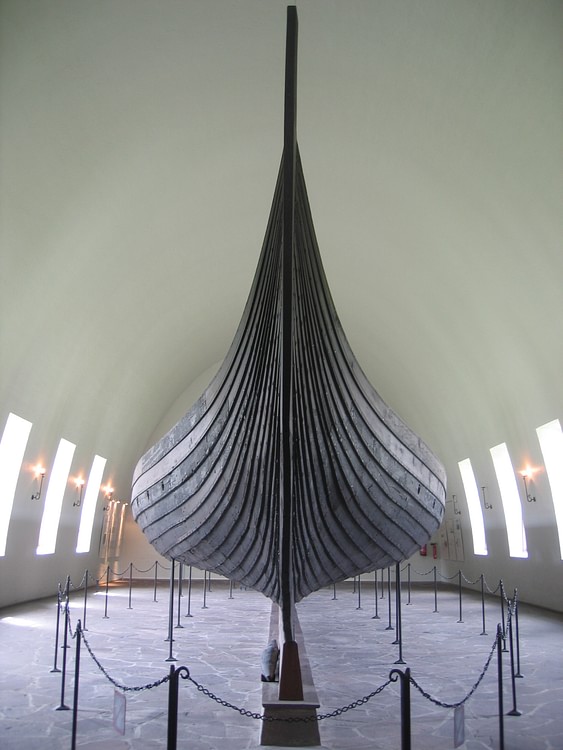
Oseberg Viking Ship
Access to enough sturdy timber to foresee in the Vikings’ heavy demand for ships was luckily not much of an issue in woodland-covered Scandinavia, although oak – the first-choice pick - did not grow in the northern parts, where pine was used instead. With no saws in sight in northern Europe until the 13th century CE, Scandinavian craftsmen created planks by splitting tree trunks that were differently shaped depending on where they were to be used in the ship; floor planks were deep and narrow towards the keel, but broad and flat towards the tops where more flexibility was required. Iron, used both for tools and for fastenings such as rivets, was also so readily available that even farmers with a decent degree of wealth could source enough materials and manpower to build themselves a ship.
EARLY TYPES OF VIKING SHIPS
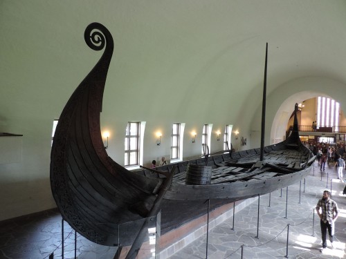
With the Viking raids kicking off just before 800 CE, we obviously know that by then the Scandinavians were capable of producing seaworthy, sailing vessels. The problem is that most of the ships that date back to this early stage of the Viking Age now seem to decorate our ocean floor or are decayed beyond recognition. So, in terms of tangible remains, our image of Viking ships is visually ruled by the rich ship burials containing the Oseberg (c. 820 CE), Gokstad, and Tune (both c. 900 CE) ships found in Oslo fjord in Norway.
The Oseberg ship is the earliest preserved Scandinavian sailing ship and comes in at 21,5 meters long, 5,1 meters broad, with room for 15 pairs of oars; broader (and deeper, too) than for instance the slender Nydam ship and the slim longships that would appear towards the end of the 10th century CE. Beautifully decorated with wood-carvings, the Oseberg was probably associated with the lofty tops of society, and although she was seaworthy and has all the main Viking ship features, she was not yet as capable as later ships. The already much more seaworthy Gokstad was a little larger and considerably deeper, and also had oarlocks; sailing ships benefited from retaining oar-support, too. Both of these seem to have been fairly robust and all-round vessels that could be used in both warfare and for transport purposes (possibly fitting into the kjóll ship type). The Tune ship was sort of a sized-down version of the Gokstad, with a similar purpose.

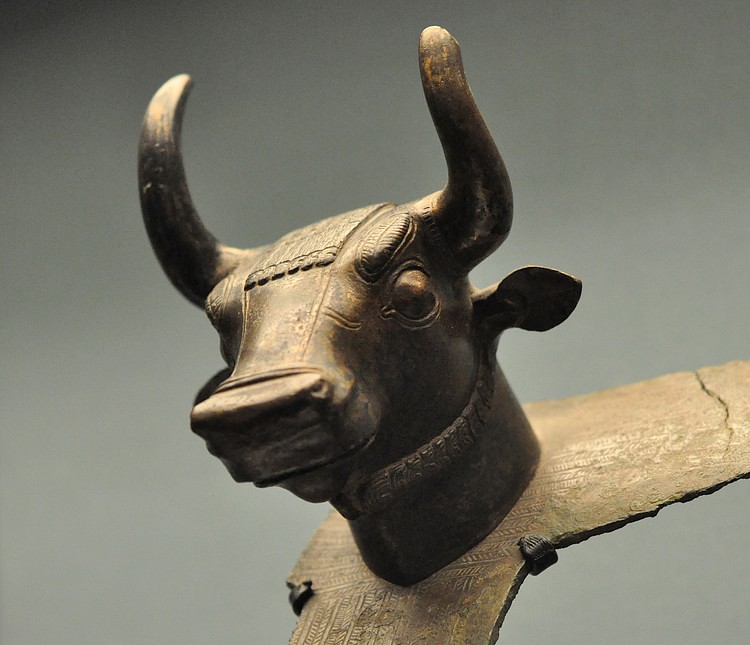
Oseberg Animal Head
However, more dedicated warships were also around at this point in time, with the term knarr (or knǫrr, plural knerrir) seemingly indicating early warships with backward-curving stems. Finds such as the small-ish warship from Ladby, Denmark found in a ship burial dated to c. 925 CE, which is lower, slimmer, and faster than the Oseberg and Gokstad ships, show that by the end of the 9th century CE specialisation was already occurring throughout Scandinavia. The warship’s main purpose was not to fight sea-battles (although these did occasionally occur) but rather to navigate sheltered waters to transport its fearsome warrior crew to a point of interest, dropping them off and swiftly picking them and their loot back up again when the moment came. Bigger-bellied all-rounders, instead, could properly handle open waters and could carry both people – warriors or not – and goods.
A VISIBLE INCREASE IN SPECIALISATION
Properly specialised cargo ships do not appear in our record (which does not mean they did not exist earlier on, however!) until the 10th century CE, which is also when warships become longer and more slender to the point they can confidently be called longships and begin to appear more frequently than before. Old Norse terminology specialises here, too, with the knarr now attached to the new cargo ships (which also had backward-curving stems, explaining why the term could carry over), while longships were potentially called skeiðar (sing. skeið) if they were extremely long, serpent- or drakkar ships when dragon-heads were present, and snekke/snekkja when slightly smaller.
ON LONG DISTANCES THE VIKINGS TRIED TO ISLAND-HOP OR GET WITHIN SIGHTING RANGE OF KNOWN LANDMARKS, AND RELIED ON THE SUN & STARS, WAVES & WIND, AND CLOUDS & ANIMALS.
Generally seen as one of the most important points of shipbuilding progress in the later Viking Age, cargo ships relied heavily on the sail and were sailable by a small crew while having a large carrying capacity. The Hedeby ships, for instance, which are dated to c. 1025 CE, might have been able to hold as much as 60 tons of goodies. Longships, on the other hand, used both oars and sails to reach their frighteningly high speeds which were so instrumental to the Viking raiders’ hit-and-run tactics. They were also narrower than most of the ships from the early Viking Age; the Viking Ship Museum in Roskilde, Denmark, states that archaeologically, ships have to be at least five times as long as they were wide to be classified as longships. The longest known longship, known as Roskilde 6, dates to after 1025 CE and with its staggering length of 36 meters she helps illustrate the fact that longships were made ever longer during the Late Viking Age. Besides these two subtypes, which remained in use throughout the rest of the Viking Age, there is plenty of indication that a load of different, smaller boats would have cluttered up the Scandinavian waterways too.
The two types reflect changes in Scandinavian society which took place during the 10th century CE. Kingdoms expanded and the power of kings and chieftains rose, and because of the abundance of water and waterways, political power was inextricably connected with maritime might – which is where the longships came in handy. At the same time towns grew out of earlier trading centres, taking in ever more trade goods which all needed to be profitably transported, not just close to home but also to the North Atlantic Viking territories such as Scotland and Iceland. People, cattle, and useful supplies were obviously also not going to swim those distances; dedicated, open-sea traversing cargo ships were clearly very useful in this regard.
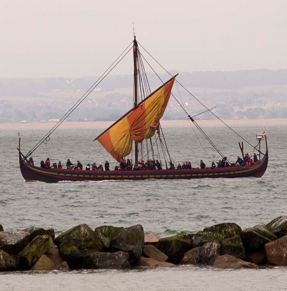
Viking Longship Replica
NAVIGATION
With Viking ships ready to scoot across any sort of distance, it obviously helped if its crew knew where to go. When staying close to the coast, navigation was generally not that much of an issue, as explanations highlighting landmarks such as funnily shaped cliffs and the amount of time between certain points would usually suffice. The Vikings often enhanced such features with stone cairns stuck on top of them. Atlantic voyages, however, where one could happily sail for days without sighting land at all, were a different matter altogether.
The compass, sea-chart or logs do not seem to have been known or used in Viking navigation. Instead, it looks like, on these long distances, the Vikings tried to island-hop or at least get within sighting range of known islands functioning as landmarks, while knowledge of sun and stars, common wave- and wind patterns, the way clouds behave over land, and the appearance of birds and sea mammals all helped out. The northern skies were too light during summertime for stars to be visible, however, and the sun is obviously not a reliable friend either: fog could cause ships to get disoriented at sea. Firsthand experience on the routes the Vikings sailed was obviously valuable; one can only imagine the uncertainty a Viking crew must have faced on first-time exploration journeys. Fierce Erik the Red, for instance, who would famously colonise Greenland, lost more than half of his ships during his first journey there, and the remaining ones were pushed back towards Iceland or wrecked altogether.
Some useful Viking routes were, for instance, from Denmark to the Mediterranean – an entirely coastal affair; from northern Denmark to England, which took two or three days; from western Norway to Scotland or the Irish sea probably via the Shetland and Orkney Islands, with only limited stretches of open sea; and the true long-haul, open-sea routes from Norway or Ireland to Iceland and Greenland. The early 14th-century CE Icelandic Hauksbók manuscript – which contains versions of older material, too – has instructions on how to get from Norway to Greenland and gives us a decent indication of the sorts of techniques and experiences the Viking sailors had access to; the focus lies on a very detailed description which adapts the way landmarks help out coastal navigation for use on the open seas.
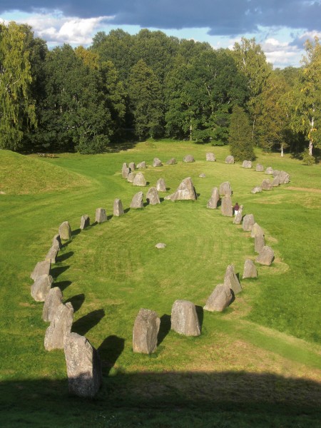
Scandinavian Stone Ship Burial
PLACE IN SOCIETY
Ships were clearly pivotal to Scandinavian society as a whole as in a landscape with so many waterways ships were used in every rung of society, including the highest; Viking rulers heavily depended on ships to reach (and consequently exercise control over) all the nooks and crannies along their territories’ coastline or rivers. These same waterways moreover provided a much more convenient way of transporting goods and facilitated quicker communication than overland, also across longer distances to overseas settlements.
Culturally, Scandinavian ships burst through the barrier of history to emphasise their importance through the many ship burials that have been unearthed across Scandinavia even beginning before the Viking Age. The simplest form were graves marked by stones laid out in the pattern of a ship, but, more spectacularly, occasionally actual full-fledged ships were stuck into the grave-mounds. Imagine a trench with a ship inside it, covered by a mound, with generally at least one human body buried inside it, usually in a small chamber amidships or laid out on the deck. An enormous variety of grave goods and personal possessions, subject to great regional variation, accompanied the dead, and animal sacrifices were also common. The Oseberg ship burial – the richest Viking grave ever found - for instance, contained perhaps as much as 20 decapitated horses alongside its human occupants: a noblewoman and (probably) her handmaid. Sometimes the vessels were burnt, though. Macabrely, Viking ship burials, in particular, seem to be connected with human sacrifice, as seen in many ship-related graves containing people who had been deliberately killed (as evidenced by their decapitation, stabbing, broken necks, etc.) to tag along with the grave’s main occupant.
Of course, Viking expansion and overseas influence would never have been possible without technologically sound ships. Merely in terms of exploration and colonisation, their ships allowed the Vikings to reach and settle in the British Isles, Iceland, Greenland, through the Mediterranean, and even across to Newfoundland in North America (‘Vinland’). The speed and agility of their vessels turned their quick hit-and-run tactics into a big hit, thus playing a key role in warfare, too – the option of oars and their shallow draft allowing the ships to drop its crew off virtually anywhere, even close to almost landlocked targets such as Paris. This, then, is where the nightmare-image of dragon-heads descending upon unprepared targets must have really come alive for the Vikings’ victims.
Urartu Civilization › Origins
Definition and Origins
Urartu, also known as the Kingdom of Urartu or the Kingdom of Van, was a civilization which developed in the Bronze and Iron Age of ancient Armenia, eastern Turkey, and northwestern Iran from the 9th century BCE. Controlling territories through military might and the construction of fortresses, the kingdom boasted a lively production in the arts, especially metalwork. Surviving only two centuries, the kingdom mysteriously disappeared in the 6th century BCE and was only rediscovered as a distinct and recognisable ancient culture by excavations carried out in the 19th century CE.
The history of Urartu remains fragmentary due to a lack of extended written sources and an overreliance on potentially biased sources from contemporary enemy states such as Assyria. Nevertheless, surviving inscriptions, architecture, and artefacts, together with ongoing archaeological investigations have helped re-create a sufficiently detailed history to indicate the undoubted importance of one of the region’s most influential ancient cultures.
NAMES
'Urartu' comes from urashtu, the Assyrian word for the kingdom, and signifies “high place”, possibly referring to either the mountainous region or the culture’s common practice of building fortifications on rock promontories. To the Babylonians they were uruatri, and to the Hebrews the kingdom was known as Ararat. The Urartians called themselves Biaina and their state Biainili (or Land of the Nairi).
BY THE 7TH CENTURY BCE, URARTU CONTROLLED TERRITORY WHICH STRETCHED FROM THE CASPIAN SEA TO THE UPPER EUPHRATES.
PROSPERITY
Urartu sprang from a confederation of kingdoms which had developed from the 14th or 13th century BCE onwards. A recognisable and independent state known as Urartu developed from the 9th century BCE which combined these smaller kingdoms, probably in response to an external threat from Assyria. The culture prospered thanks to settlement on the extensive fertile plateau which was well-supplied by rivers. Crops included wheat, barley, millet, rye, sesame, and flax. Viticulture was also important, wine-making in the region perhaps being the earliest anywhere. Remains of fruit found at Urartu sites include plums, apples, cherries, quinces, and pomegranates.
Animal husbandry prospered thanks to excellent mountain pastures, and sheep, goats, cattle, and horses were all bred. Mineral deposits in the area included gold, silver, copper, lead, iron, and tin. The location on the trade routes between the ancient Mediterranean and Asian and Anatolian cultures was another source of prosperity. Although protected by mountains in the north and south, defence was perpetually necessary against attackers from the east and west eager to capitalise on the region's wealth.

Urartu
GOVERNMENT & TERRITORY
The government of Urartu functioned around a centralised monarchy with a close circle of advisers and a much larger group of civil administrators who supervised temples and such construction projects as fortresses, roads, and canals. The fortress capital, Tushpa, was built on a limestone promontory on the eastern shores of Lake Van in the highlands. Tushpa would later be called Van and perhaps had a population as high as 50,000 at its peak. The capital also had a royal necropolis composed of chambers cut into the mountain on which the city was built. Other surviving remains include an open-air shrine with smooth walls and many inscriptions made into the rock. Regional governors represented the king in the provinces, administered justice, and collected taxes in kind, which were channelled back to the capital.
The kingdom’s first known monarch was Arame who reigned c. 860-840 BCE. Assyrian sources mention that the kingdom first rose to prominence from c. 830 BCE under the king Sarduri I (r. c. 835-825 BCE) whose descendants would rule for the next two centuries. In 776 BCE, Argishti I (r. c. 785-760 BCE) would found a new city, Argishtihinili, on the Plain of Ararat, later to become the second city of the kingdom and renamed Armavir. Then, c. 685 BCE, king Rusa II (r. c. 685-645 BCE) founded the important northern city of Teishebaini(modern Yerevan), also on the Ararat plain. Other important Urartu centres were Bastam, Karmir Blur, Adilcevaz, and Ayanis.
THE STATE CONTROLLED LARGE AREAS OF AGRICULTURAL PRODUCTION THANKS TO ANNUAL CAMPAIGNS BY ITS ARMY & A NETWORK OF FORTRESSES.
The state controlled large areas of agricultural production thanks to annual campaigns by its army and a network of fortresses. The policy of rulers towards weaker neighbouring tribes was sometimes one of confederation and the extraction of tribute in the form of goods and slaves rather than conquest. However, there are notable cases of the seizure of slaves such as Argishti I’s campaigns against the Hatti and Dsopk in the 780s BCE when he was said to have captured 320,000 slaves. By the 7th century BCE, Urartu thus controlled territory which stretched from the Caspian Sea to the Upper Euphrates (east to west) and the Caucasus mountains in the north to the Taurus Range in the south.
WARFARE
All Urartu kings seem to have led their armies in battle. Weapons, as indicated by those dedicated at temples, included iron and bronze swords, spears, and javelins, as well as bows. Heavy shields were used which had large central bosses decorated with images of mythical creatures, bulls, and lions. There is also evidence of helmets and metal scale armour, at least worn by the elite. The chief adversary was the Neo-Assyrian Empire, although there is also evidence of trade relations between the two states. Given the use of chariots by the Assyrians, it would seem reasonable to suppose that their adversary also employed them, especially given the Urartians fame for horse breeding. Urartu did enjoy some victories in the mid-8th century BCE, but the Assyrian ruler Tiglath-Pileser III (r. 745-727 BCE) was more aggressive than his predecessors and he laid siege to Tushpa. Another significant conflict between the two states was during the campaign of Sargon II (722-705 BCE) in 714 BCE. Other enemies of Urartu included the Cimmerians, Scythians, and finally the Medes.
RELIGION
Offerings of food, weapons, and precious goods, libations of wine, and animal sacrifices were all made to the gods in dedicated outdoor ritual spaces and at false doorways carved into rock faces which were known as “Gates to the Gods”. The pantheon of the Urartu religion contains a mix of unique and Hurrian gods such as the god of storms and thunder Teisheba, from the Hurrian Teshub. The mid-9th century BCE king Ishpuini promoted Haldi (Khaldi) to the head of the gods, a deity of foreign origin, although his role and function are obscure besides that he was associated with warfare. Haldi is often portrayed as a man standing on a bull or lion, symbolic of his power.

Bas Relief of Khaldi
Haldi, in particular, had temples built in his honour, which have distinctive square towers with reinforced corners. So important was this god that the Urartians were sometimes called the Haldians or “children of Haldi”. The ruling king was known as the “servant of Haldi” and all wars were carried out in his name.
Another important deity was Shivani, the Sun god who, given his representation with a winged solar disk, was likely inspired by the Egyptian god of the same association, Ra. The consort of Haldi, Arubani, was the most important female goddess; Sielardi was the moon goddess, and Sardi a star goddess. Urartu art includes the Tree of Life symbol common to Mesopotamian cultures and is usually shown with a figure stood either side making offerings.
ARCHITECTURE
The Urartians were innovative and ambitious architects. Significant construction projects include the 80-kilometre long stone-lined canal which brought fresh water from the Artos mountains to the capital. The structure was built by king Menua (r. c. 810-785 BCE) and allowed the proliferation of vineyards and orchards resulting in Tushpa gaining a reputation as a garden city.
Although few structures survive today, an example of an Urartu temple can be seen in a relief in the palace of the Assyrian king Sargon. The relief shows the temple of Haldi at Ardini before it was sacked by the Assyrians in 714 BCE. The building has a hexastyle portico (six-columned facade) and triangular pediment, shields hang from the exterior walls and a great urn stands either side of the entrance.
Although little remains of Urartu fortifications, one of the most significant and best-preserved fortresses is at Erebuni near today’s capital of Armenia, Yerevan. Built during the reign of king Argishti I, impressive sections of the fortification walls still stand today. Typical features of Urartu fortifications are massive walls supported by stone foundations made of large square blocks and buttressed with towers. In Assyrian reliefs of Urartu fortifications, these towers are crenellated and have windows. Their survival since antiquity is a testimony to the building skills of the Urartians, especially considering the region is subject to frequent and powerful earthquakes.
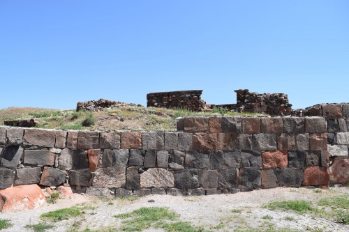
Ruins of Erebuni Fortress
Palace buildings are composed of multiple chambers and larger halls, the former usually with the roof supported by a centrally placed wooden column and the latter by multiple rows of columns. Other features are open courtyards and storerooms where large potteryjars were sunk into the floor to hold foodstuffs, wine, and beer. The larger examples of these sunken jars have a capacity of around 750 litres (200 gallons) each. Structures located away from residential buildings, probably because of the fire risk, include potteries and smelting kilns.
INTERIOR WALLS COULD CARRY FRESCOES & SOMETIMES THEY ALSO HAD CAVITIES CUT INTO THEM INTO WHICH WERE PLACED DECORATIVE BRONZE PLAQUES.
Materials used include large “cyclopean” blocks placed together without mortar, worked stone blocks, and mud bricks. Roofing was made using wooden beams or barrel vaults of adobe bricks. Flooring was of stone in the more prestigious buildings with surviving examples having either large basalt slabs or even large-stone polychrome mosaics with geometric designs. Interior walls could carry frescoes, and sometimes they also had cavities cut into them into which were placed decorative bronze plaques or cut stone slabs in red, white, or black. Doors were made from thick planks of wood and locked using a hinged bronze latch.
MATERIAL CULTURE
The wealth and prosperity of Urartu is attested by ample surviving evidence of its material culture, notably pottery, objects utilised as religious dedications, and examples of bronze-working. No large-scale stone sculptures survive except in fragments. Excavations have revealed both public and private buildings in Urartian cities with interior wall paintings. Painted on plaster, surviving fragments show scenes with animals, mythical creatures, processions of gods, and scenes from everyday life such as agriculture and hunting. Backgrounds are usually white, outlines are drawn in black, and blue and red are the most commonly used colours.
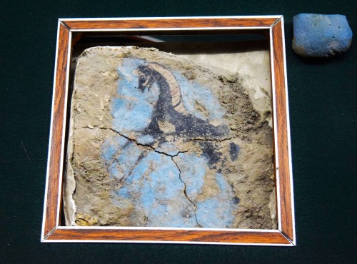
Urartian Horse Mural Fragment
Metalworking has a long history in the region, dating back to the 10th millennium BCE. Artisans in the Urartu kingdom produced such goods as jewellery, horse bits, helmets, buckles, and candelabra in bronze and copper. Large bronze cauldrons with animal or human heads around the rim were produced in numbers. Metal goods were cast, embossed, inlaid with gold or etched with designs. Urartu art is best seen in bronze sculptures made in the round which show an influence from Assyria, particularly in the choice of subjects - lions, bulls, mythological creatures such as griffins and centaurs, and military themes, especially horse riders. Religious art includes bronze figurines of prominent gods such as Haldi, Teisheba, and Shivani. Some deities are unidentified such as a female goddess rendered in bone and hybrid figures of a fish-man, bird-man, and scorpion-man. Those bronze items belonging to the royal household are so identified by inscriptions which have also helped to identify Urartu works found outside Asia such as in Etruscan tombs in central Italy. Other materials used in Urartu art include ivory, semi-precious stones, and stag horns.
Early Urartu writing used simple pictograms, but cuneiform was adopted and adapted from neighbouring contemporary Mesopotamian cultures. Surviving cuneiform inscriptions from the kingdom, of which there are some 400 examples, show that the Urartian language was related to Hurrian, with the two languages probably sharing a common ancestor language dating to the 3rd or 2nd millennium BCE.
DECLINE
In the 7th century BCE, the Urartu kingdom came to a mysterious but violent end when sometime between c. 640 and c. 590 BCE their cities were destroyed. The state was probably weakened by decades of battles with the Assyrians, and it may have been too overstretched to control its own empire. The perpetrators are not known but the Scythians are one candidate, the Cimmerians another, and even possibly forces from within the territories administered by the Urartu kings.
Finds of three-pronged arrowheads, typical of Scythian archers, found at the destroyed site of Teishebaini are suggestive. The destruction of the city by fire sometime between 594 and 590 BCE seems to have been unexpected, with granaries recently filled and weapons and precious belongings seemingly abandoned in a hurry. It is likely that the various cities of Urartu succumbed at different times to different peoples over a period of two or three decades.
The territories the Urartu kingdom had once occupied were ultimately taken over by the Medes from c. 585 BCE onwards and then incorporated into the Achaemenian Empire of Cyrus the Great in the mid-6th century BCE. The Urartian language, however, would survive into the Hellenistic period. Many Urartian towns would become the location of important settlements throughout antiquity, and many of their Urartu names survive today. Unrecorded and unknown to ancient Greek historians, Urartu would have to wait until archaeological excavations in the 19th century CE to take its place as an important regional Bronze Age culture.
This article was made possible with generous support from the National Association for Armenian Studies and Researchand the Knights of Vartan Fund for Armenian Studies.
Bronze Age Sicily › Origins
Ancient Civilizations
The Bronze Age in Sicily, considered one of the most important periods of the island's prehistory, witnessed the establishment of a unitary and in some ways artistically vibrant culture. The three main phases of the period take their name from the most important centres at the time in question: Castelluccio (Early Bronze Age), Thapsos (Middle Bronze Age) and Pantalica (Late Bronze Age). There was a marked increase in cultural and commercial trade between regions near and far, particularly with Cornwall, across the Atlantic coasts of France, Spain, Sardinia, the Tyrrhenian coast to the Strait of Messina, and from here to the Aegean- Anatolian area. It was a world, therefore, in great turmoil, that felt the need to interconnect to achieve a better future.
EUROPEAN CHARACTERISTICS
Around the end of the 3rd millennium BCE, Europe was involved in a series of technological and social events which developed in metallurgy and in the birth of hierarchical societies. The usage of bronze (2300-1750 BCE), a resistant metal alloy which is easily malleable, permitted the manufacture of a wide range of metal tools such as razors, axes, and blades, that provided for improved living standards of tribes (consisting of 20-30 people) which, in turn, contributed to population growth. These bronze items brought the dawn of mobile and unalterable wealth. Examination of the organization of the tomb areas found in the European necropoles of this era shows that societies began to evolve different classes within them. For instance, singular tombs were used for eminent figures whilst small groups of monumental tombs were employed as the eternal home of important families.

Prince's Tomb (Cava Lazzaro, Ragusa, Sicily)
During the Middle Bronze Age (1700-1350 BCE) human settlements became more and more permanent and populous, and the communities settled on a territory, dedicating themselves to the manufacture and distribution of metal artifacts. The most common form of dwelling was the hut - circular or oval in shape. Agricultural practices were greatly developed, including the introduction of the simple plough (asymmetrical ploughshare). Animal husbandry was no longer solely for meat production, but also for animal products, such as milk and wool. The dead continued to be buried in graves or inside caves where combustion traces and animal bones have been found indicating the practice of funeral rites.
METALWORKING TOOK ON CONTINENTAL DIMENSIONS, UNITING THE TWO SHORES OF EUROPE.
The Recent Bronze Age (1320-1170 BCE) witnessed the strengthening of villages following a precise and deliberate security planning, such as the digging of ditches and erection of embankment fortifications. Metalworking took on continental dimensions, uniting the two shores of Europe: the shapes of metal objects of this period, in fact, are very similar both in the south and the north of the continent and highlight the wide circulation of products and models. This was the period in which economies were being standardised, thanks to the intense circulation of people, things and ideas.
The Final Bronze Age (1170-770 BCE) saw the transition from tribal societies to aristocratic societies, the increase in large bronze hoards and craft developments aimed at producing goods for an evermore emerging aristocracy. In much of Europe, the Urnfield culture developed, a phenomenon so extensive that one is led to think that this was an age of migrations. Common practices included funeral rites which provided for the cremation of corpses and the deposition of the ashes in urns buried in extensive fields, together with small ceramic vessels, such as bowls and cups, which probably contained food offerings.
EARLY BRONZE AGE SICILY
In Sicily the oldest phases of prehistory were overcome at the end of the 3rd millennium BCE, when it received a new cultural wave, probably from the Middle East, today labelled with the name of the Castelluccio culture, from the homonymous prehistoric site near the city of Noto. This cultural facies (segmentation), rather unusual compared to those of the CopperAge, is verified in the south-east and south of the island, up to the provinces of Agrigento and Caltanissetta (in the west and in the middle of the island), and constitutes the “starting line” of the Sicilian bronze age. It is certainly dated to 2169±120 BCE (calibrated value) thanks to radiometric dating performed on 18 coal samples which proved to be the oldest of this culture and which were found at the archaeological site of "Muculufa", a few kilometres north-east of Licata town.

Sicily in the Early Bronze Age
At this early stage of the Bronze Age, Sicily was divided into four macro-regions, each one of them with their own culture: northern Sicily with the Rodì-Tindari-Vallelunga culture, the western one, with the Naro/Partanna culture, the south-east with the Castelluccio culture and the Capo Graziano culture of the Aeolian Islands. Of these, that of Castelluccio seems to be the most homogeneous culture in this period, perhaps because it spread over a larger area and, consequently, it is much better known today.
The prehistoric settlement of Castelluccio was built on a rather isolated but defensible rocky spur. The archaeologist Paolo Orsi, who identified it between the late-19th and early-20th century CE, found large quantities of ceramic fragments among the refuse and explored the artificial cave tombs. These tombs are oven-shaped and dug into the rocks. There are small oval-shaped rooms with a diameter of between 1.5-2.0 metres, sometimes preceded by an ante-cella and still containing gravegoods. The Castelluccian villages, sometimes fortified, showed a rather interesting agricultural and pastoral reality. Their ceramics have been classified as "matt-painted ware" and have close ties with an Anatolian culture of the end of the 3rd millennium BCE, so-called "Cappadocia". The wares show a variety of pottery shapes and geometric designs, the latter consisting of brown or black bands crossed on a yellow or red background. Forms include single or two-handled conical glasses, tall footed-vases known as "fruit bowls", large amphorae, bowls on a tall conical foot, and globular pyxides (boxes) on a small conical foot.
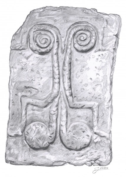
Tombstone Door (Castelluccio Culture, Sicily)
The graves dug in the rock were closed with dry-stone walls, but also with tombstone doors, some decorated in relief with spiral-shaped motifs. In two of the graves there are carved images that could allude to sex, therefore, to the continuation of life. In some of these graves carved globule bones have been found that are reminiscent of examples elsewhere (southeastern Italy, Malta, southern Greece and Troy II and III). The carved bones are animal bone segments and are between 13-15 centimetres in length. They are sometimes decorated with incisions on which, successively, globules in relief have been made. Their use is not yet known, although some scholars have supposed that these artefacts could be small idols, while others think they could be dagger handles.
No doubt the Castelluccio Civilization had dealings with Malta, given that in Manfria, a district of the city of Gela (in south-eastern Sicily), a tomb there contained ceramic fragments in the Maltese "Tarxien Cemetery" style.
MIDDLE BRONZE AGE
From the end of 1500 to c. 1200 BCE in Sicily, important coastal settlements developed and the island began to acquire strategic-commercial importance thanks to the intense exchanges with Mycenaean Greece. The find of a large number of Aegean vases in the Sicilian tombs of this period proves a phenomenon that caused the birth of real emporia in which the transmarine trades were practised, as had happened in the Aeolian islands. This was just the age that the Milazzese culture flourished in the Aeolian Islands. In Sicily, for its part, a culture closely related to the Aeolian arose, called Thapsos, from the ancient name the Greeks gave to a peninsula (nowadays Magnisi) situated between Augusta and Syracuse, which gives its name to the most famous Sicilian culture of the middle Bronze Age.

Ritual Ceramic Wash Basin (Thapsos Culture, Sicily)
The first archaeological excavations carried out in this little peninsula, about 2 km long and 700 m wide, were made around the end of the 19th century CE, and about 300 artificial cave tombs were identified, some of them Tholos tombs, with frontal entrances or through wells that open on the rocky floor. They are located in several points of the peninsula where, in the central area, another necropolis of enchytrismòs (vase-burials) has been identified, with corpses placed into large earthenware jars inserted in small natural cavities in the ground.
- The prehistoric village was located near the isthmus, and has three phases with three different dwelling types: the first phase (15th-14th century BCE) consisting of circular, oval and horseshoe-shaped huts, without a clear urban planning, except some such huts connected by a real street network in the northern part.
- The second phase (13th-12th century BCE), consisting of several rectangular rooms constituting the residential complexes, arranged in a square configuration around a central paved court, which remind a Mycenaean-type urban planning.
- The third phase (11th-9th century BCE) is characterised by a series of quadrangular environments that have no relation with the previous "backyard" buildings.
The peninsula has returned a rich quantity of ceramic material ranging from the 15th to the 9th century BCE, imported or locally produced, such as three-handled small jars, alabastra, small cups and Mycenaean small pitchers; Cypriot Base Ring II jugs and White Shaved Ware juglets; and Maltese ceramics related to the first phase of the Borġ in-Nadur culture and Bahrija style.
THIS WAS WHEN THE MYCENAEAN SAILORS SAILED UP & DOWN THE MEDITERRANEAN, INSPIRING THE TALES THEN LATER NARRATED IN HOMER'S ODYSSEY.
The local pottery consists of high-footed basins decorated with geometric patterns and cups with "sigma" incisions on the upper edge of the vase with representations of birds and fawns on the body. This was when the Mycenaean sailors sailed up and down the Mediterranean, inspiring the tales then later narrated in Homer's Odyssey and inciting the Greeks, centuries later, to seize Sicily.
LATE BRONZE AGE
In the 13th century BCE everything suddenly changed. This period would seem to have been ruled by fear: the ancient coastal settlements were moved to higher sites, difficult to access but easily defendable, such as Pantalica, Montagna di Caltagirone, Dessueri, Sabucina and, later, Cassibile (all areas between south-eastern and central Sicily). While in the Aeolian Islands the Ausoni flourished, a civilization which came from the Italian peninsula, in Sicily a civilization strongly influenced by the Mycenaean one still persisted.
The historical sources (Hellanicus of Mytilene, Fylistus of Syracuse) assert this was the Sicels' time for Sicily, who also came from the Italian peninsula between the 13th and 12th century BCE. However, the archaeological layers following the Thapsos age do not confirm the presence of an Italic civilization. On the contrary, dating to this period is a monumental building made up of several rectangular rooms, the so-called Anaktoron or prince' palace. Built with megalithic techniques using gigantic stone blocks, it is a smaller imitation of the Mycenaean palaces. It also lacks the cremation of the deceased, which, in contrast, was widespread in the Italian peninsula of that era. The ritual will remain unknown in Sicily for a few more centuries yet. The Sicels, therefore, landed a few centuries later in eastern Sicily and drove away the Sicanians to the western part of the island, the dominant population who had lived on most of the island since time immemorial.

Large Sicilian Bowl (Finocchito Facies, Sicily)
Due to the great confusion of peoples, scholars divide this period into four distinct phases, named after the most characteristic site of this age, Pantalica (a plateau a few kilometres northwest of Syracuse, surrounded by canyons and including five large necropolis with "artificial cave tombs").
Pantalica North
The first phase (13th-11th century BCE), called Pantalica North, is characterized by the Anaktoron that has already been mentioned about and by a pottery shaped on the lathe (a tool used for the first time in Sicily), red and shiny, on high tubular feet similar to those of Thapsos. The personal items and jewellery (blades, pocket knives, swords, necklaces, rings) seem to have a clear Mycenaean influence and denote a large circulation of bronze material. The most characteristic object of this age is the fibula, i.e. a pin for fastening garments, in the simple or violin arch shape.
Cassibile
In the second phase of Pantalica (11th - first half 9th century BCE), named Cassibile from the village near Syracuse where typical tombs of this age are dominant (rounded or rectangular rooms, arranged around a common entrance), there is a replacement of the red pottery by another type painted with feather patterns, similar to those of the Aeolian islands. For its part, the fibula took the shape of an elbow bent bow known as the fibula of Cassibile, after the name of a Syracuse hamlet. That kind of fibula was also present in 11th century BCE Palestine, and the Sicilian bronze objects of this period (fibulae, axes, razors) are very similar to those of Spain and the Atlantic coasts of France and England. A significant phenomenon of this phase is the reoccupation of coastal sites, which encouraged the resumption of maritime trade.
Pantalica South
During the third phase or Pantalica South (second half 9th century BCE - second half 8th century BCE), peoples moved back once again to the Pantalica massif, according to the artificial cave tombs which are numerous, especially in the southern flanks of the hill. Pottery wares appeared imitating Greek decorations, such as the trilobed oinochoai for instance, painted with Aegean geometric designs, while the "feathered painting" was still used in combination with a "parallel furrows" decoration. Discoveries of rings, buttons and spirals are very frequent.
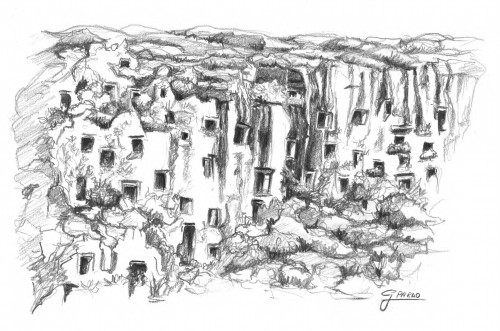
Rock Necropolis of Pantalica
Finocchito
The last phase (second half 8th century BCE - second half 7th century BCE), the fourth, namely Finocchito, a hilly site a few kilometres southwest of the town of Avola, saw the foundation of Greek colonies in large parts of the island which were significantly affected by their culture. The natives now imitated Greek handicraft products both in form and in decoration, producing a rather beautiful ceramics, decorated with Aegean late-geometric motifs. The previous ages fibula also assumed a typically Greek shape, small lozenge and arch-shaped; furthermore, jewellery was produced made of simple or double knitted chains with different shaped pendants. This is the time when iron made its appearance, with which were made knives, spear cusps and especially fibulae. In the Sicilian tombs, now single-celled (that could suggest the birth of private land ownership), there are Greek manufactured objects (proto-Corinthian vases or ivory fibulae) identical to those found in Greek archaic Syracuse tombs.
With the conquest of Sicily by the Greeks (late 8th century BCE), the island not only came out of Prehistory but it was also the end of the previous civilizations. Even that of the Sicels, who were subdued and blended together with the Greeks, until finally disappearing from history in the 4th century BCE.
LICENSE
Article based on information obtained from these sources:with permission from the Website Ancient History Encyclopedia
Content is available under License Creative Commons: Attribution-NonCommercial-ShareAlike 3.0 Unported. CC-BY-NC-SA License