Gordium › Roman Roads » Origins and History
Articles and Definitions › Contents
- Gordium › Ancient History
- Roman Roads › Antique Origins
Ancient civilizations › Historical places, and their characters
Gordium › Ancient History
Definition and Origins
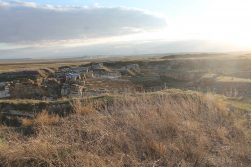
Gordium was the capital of ancient Phrygia, modern Yassihüyük. It is situated on the place where the ancient Royal road between Lydia and Assyria / Babylonia crosses the river Sangarius, which flows from central Anatolia to the Black Sea.Remains of the road are still visible. In the ninth century BCE, the city became the capital of the Phrygians, a Thracian tribe that had invaded and settled in Asia. They created a large kingdom that occupied the greater part of Turkey west of the river Halys.
The kings of Phrygia built large tombs near Gordium. These wooden chambers were covered by artificial hills that are usually called tumuli. There are about eighty of them; forty have been investigated by archaeologists, and turn out to cover the period from the eighth to the first century BCE.
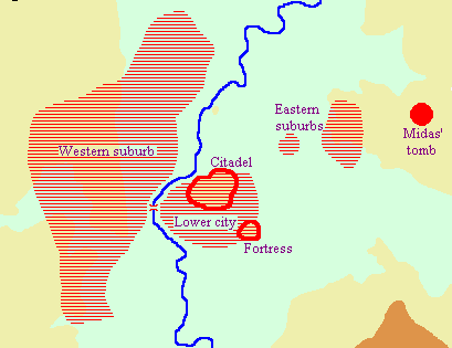
In the eighth century, the citadel was fortified and in the next century, the town became very large indeed. A palace was built in the citadel. To the south of it was a lower city, and a large suburb was to be found on the other bank of the Sangarus.
The most famous king of Phrygia was Midas, who is little more than a name to us. However, contemporary Assyrian refer to a Mit-ta-a, king of Muški. If he is identical to the legendary Midas - which is contested - he cooperated with the rulers of Tyana, Karkemiš, Gurgum, and Malida against the Assyrian king Sargon II, but was attacked by a nomadic tribe called Cimmerians.In 710/709, Midas was forced to ask for help from Sargon. This did not prevent the Cimmerian invasion. Another source, the Chronicle of Eusebius, tells us that the legendary Midas died in 695 - he may have committed suicide after a lost battle. There are traces of destruction at Gordium, but they may be older than the attack by the Cimmerians - and, again, it is unclear whether Muški is identical to Phrygia amd Mit-ta-a to Midas.

Phrygian Captive, Corinth
The "mound of Midas", the greatest tumulus near Gordium, was excavated in 1957. Its diameter is a little short of 300 meters and it is 43 meters high. In the wooden chamber, which measured 5 x 6 meters, a man's corpse was found, and even the contents of his last dinnerr could be reconstructed. The tumulus also contained one of the oldest alphabetic inscriptions outside Phoenicia (c.740 BCE).
After half a century of confusion, western Turkey was reunited by the Lydians, whose first great king was Gyges (c.680-c.644).During the reign of one of his successors, Alyattes (c. 600-560), the wall of the citadel was rebuilt, while a massive fortress was built on a hill next to it. From this moment on, Greek ceramics became fashionable: initially from the Ionian cities, later also from Laconia, and especially Athens.
After half a century of confusion, western Turkey was reunited by the Lydians, whose first great king was Gyges (c.680-c.644).During the reign of one of his successors, Alyattes (c. 600-560), the wall of the citadel was rebuilt, while a massive fortress was built on a hill next to it. From this moment on, Greek ceramics became fashionable: initially from the Ionian cities, later also from Laconia, and especially Athens.
When Lydia was conquered by the Persian king Cyrus the Great and its last king Croesus killed (after 547), a Persian garrison took possession of this fortress. Gordium was now included in the satrapy of Greater Phrygia. Ceramics from this period sometimes imitate Achaemenid silver vessels, while the town appears to have exported textile.
The garrison stayed there until the last months of 334, when the Macedonian commander Parmenion captured the city. During the winter, his king Alexander the Great joined him. (Go here for the famous story about Alexander cutting the Gordian knot in the palace.)
Gordium, capital city of ancient Phrygia
After the troubles following the death of Alexander in 323, Gordium was first ruled by Antigonus, then by the Seleucid kings of Asia, then by the Celts (the remains of their human sacrifices have been found), then by the Attalid rulers of Pergamon, and eventually by the Romans.
It remained one of the most important commercial centers in the region, still producing textiles. However, the size of the city itself diminished. The old center - citadel and lower town - was abandoned after the Roman conquest in 189 BCE; only the western suburbs remained occupied. (From the first until the fourth century CE, part of the citadel was again in use.) Gordium was still in existence in the sixth century, and was probably called Vindia, which suggests that people no longer remembered its Phrygian past.
Roman Roads › Antique Origins
Ancient Civilizations
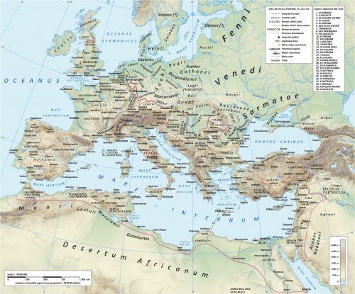
The long straight roads built by the Romans wherever they conquered have, in many cases, become just as famous names in history as their greatest emperors and generals. Building upon more ancient routes and creating a huge number of new ones, Roman engineers were audacious in their plans to join one point to another in as straight a line as possible whatever the difficulties in geography and the costs in manpower. Consequently, roads used bridges, tunnels, viaducts, and many other architectural and engineering tricks to create a series of breathtaking but highly practical monuments which spread from Portugal to Constantinople. The network of public Roman roads covered over 120,000 km, and it greatly assisted the free movement of armies, people, and goods across the empire. Roads were also a very visible indicator of the power of Rome, and they indirectly helped unify what was a vast melting pot of cultures, races, and institutions.
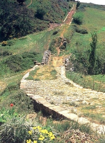
Roman Road, Spain
THE ROMAN ROAD NETWORK
The Romans did not invent roads, of course, but, as in so many other fields, they took an idea which went back as far as the Bronze Age and extended that concept, daring to squeeze from it the fullest possible potential. The first and most famous great Roman road was the Via Appia (or Appian Way). Constructed from 312 BCE and covering 196 km (132 Roman miles), it linked Rome to Capua in as straight a line as possible and was known to the Romans as the Regina viarum or 'Queen of Roads'. Much like a modern highway, it did not go through less important towns along the way, and it largely ignored geographical obstacles. For example, the impressive 90 km stretch from Rome to Terracina was built in a single straight line.The road would later be extended all the way to Brundisium and thus reach 569 km in length (385 Roman miles).
THE NETWORK GRADUALLY SPREAD ACROSS THE EMPIRE FROM BRITAIN TO SYRIA AND CERTAIN ROADS BECAME AS WELL-KNOWN AND WELL-TRAVELLED AS THOSE AROUND ROME ITSELF.
Other famous roads in Italy were the Via Flaminia which went from Rome to Fanum (Fano), the Via Aemilia from Placentia to Augusta Praetoria (Aosta), the Via Postumia from Aquileia to Genua (Genoa), the Via Popillia from Ariminum (Rimini) to Padova in the north and from Capua to Rheghium (Reggio Calabria) in the south, and many more besides, all with extensions made over time. The roads became so famous that they even gave their names to places and regions. The network gradually spread across the empire from Britain to Syria, and certain roads became as well-known and well-travelled as those around Rome itself. For example, the Via Domitia (begun in 116 BCE) went from the French Alps to the Pyrenees and was invaluable for troop movements in the campaigns in Spain. There was also the Via Egnatia (begun in the mid-second century BCE), which crossed the Balkan Peninsula and ended at Byzantium, making it a vital land route between the western and eastern parts of the empire.
To achieve the objective of constructing the shortest routes possible between two points (often not visible one to the other), all manner of engineering difficulties had to be overcome. Once extensive surveying was carried out to ensure the proposed route was actually straight and determine what various engineering methods were required, marshes had to be drained, forests cut through, creeks diverted, bedrock channelled, mountainsides cut into, rivers crossed with bridges, valleys traversed with viaducts, and tunnels built through mountains. Once all that was done, roads had to be levelled, reinforced with support walls or terracing and then, of course, maintained, which they were for over 800 years.
Roman Road Network
Besides permitting the rapid deployment of troops and, more importantly, the wheeled vehicles which supplied them with food and equipment, Roman roads allowed for an increase in trade and cultural exchange. Roads were also one of the ways Rome could demonstrate its authority. For this reason many roads began and ended in a triumphal arch, and the imperial prestige associated with realising the project was demonstrated in the fact that roads were very often named after the magistrate official who funded it; hence, for example, the Via Appia takes its name from the censor Appius Claudius Caecus.
ROAD DESIGN & MATERIALS
Major roads were around a standard 4.2 m wide, which was enough space for two wheeled-vehicles to pass each other.Roads were finished with a gravel surface sometimes mixed with lime or, for more prestigious sections such as near towns, with dressed stone blocks of volcanic tuff, cobbles, or paving stones of basalt ( silice ) or limestone. First a trench was dug and a foundation ( rudus ) was laid using rough gravel, crushed brick, clay materials or even wooden piles in marshy areas, and set between curb stones. On top of this a layer of finer gravel was added ( nucleus ) and the road was then surfaced with blocks or slabs ( summum dorsum ). Mountain roads might also have ridges running across the surface to give people and animals better traction and have ruts cut into the stone to guide wheeled vehicles.

Roman Road Surface
Roads were purposely inclined slightly from the centre down to the curb to allow rainwater to run off along the sides, and for the same purpose many also had drains and drainage canals. A path of packed gravel for pedestrians typically ran along each side of the road, varying in width from 1-3 metres. Separating the path from the road, the curb was made of regular upright slabs. In addition, every 3-5 metres there was a higher block set into the curb which stopped wheeled traffic riding onto the footpath and allowed people to mount their horses or pack animals. Busier stretches of main roads had areas where traffic could pull over and some of these had services for travellers and their animals too. Milestones were also set up at regular intervals and these often recorded who was responsible for the upkeep of that stretch of the road and what repairs had been made.
BRIDGES, VIADUCTS, & TUNNELS
Lasting symbols of the imagination of Roman engineers are the many arched bridges and viaducts still standing around the empire. From early bridges such as the Ponte di Mele near Velletri with its single vault and modest span of 3.6 m to the 700 m long, 10-arch viaduct over the Carapelle River, these structures helped achieve the engineers' straight-line goal. The Romans built to last, and the piers of bridges which crossed rivers, for example, were often built with a more resistant prow-shape and used massive durable blocks of stone, while the upper parts were either built of stone blocks strengthened with iron clamps, used cheaper concrete and brick, or supported a flat wooden superstructure. Perhaps the most impressive bridge was at Narni. 180 m long, 8 m wide and as high as 33 m, it had four massive semicircular arches, one of which, stretching 32.1 m, ranks as one of the longest block-arch spans in the ancient world. Two of the best surviving bridges are the Milvian bridge in Rome (109 BCE) and the bridge over the river Tagus at Alcantara (106 BCE) on the Spanish-Portuguese border.

Roman Bridge, Pont-Saint-Martin
Tunnels were another essential feature of the road network if lengthy detours were to be avoided. The most important include three tunnels built in the 1st century BCE: Cumaea, which stretched 1,000 m in length, Cripta Neapolitano measuring 705 m, and Grotta di Seiano 780 m long. Tunnels were often built by excavating from both ends (counter-excavation), a feat which obviously required precise geometry. To make sure both ends met, shafts were sometimes drilled down from above to check the progress of the work, and shafts could also be used to speed up excavation and work at the rock from two angles.Nevertheless, when working through solid rock, progress was tediously slow, perhaps as little as 30 cm a day, resulting in tunnel projects lasting years.
CONCLUSION
Roman roads were, then, the arteries of the empire. They connected communities, cities, and provinces, and without them the Romans could surely not have conquered and held onto the vast territories they did over so many centuries. Further, such was the engineering and surveying skills of the Romans that many of their roads have provided the basis for hundreds of today's routes across Europe and the Middle East. Many roads in Italy still use the original Roman name for certain stretches, and even some bridges, such as at Tre Ponti in modern Fàiti, still carry road traffic today.
LICENSE:
Article based on information obtained from these sources:with permission from the Website Ancient History Encyclopedia
Content is available under License Creative Commons: Attribution-NonCommercial-ShareAlike 3.0 Unported. CC-BY-NC-SA License