Lake Titicaca › Zapotec Civilization » Ancient origins
Articles and Definitions › Contents
- Lake Titicaca › Ancient History
- Zapotec Civilization › Antique Origins
Ancient civilizations › Historical and archaeological sites
Lake Titicaca › Ancient History
Definition and Origins
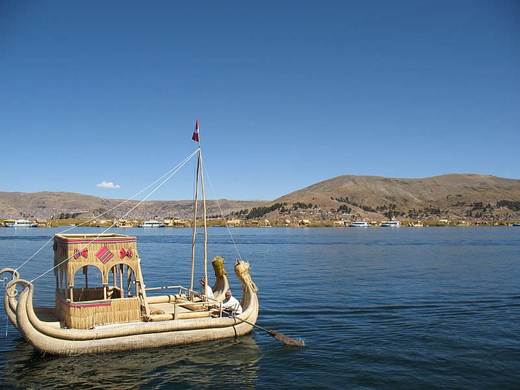
Lake Titicaca is located between Bolivia and Peru and, at an altitude of 3,800 metres (12,500 feet), it is the world's highest navigable lake. The tundra plain known as the altiplano stretches to the south and was the location of Tiwanaku, capital of one of the most important Andean cultures during the first millennium CE. The lake was also considered to be the centre of the cosmos and origin of the sun, moon, stars, and humankind and, consequently, was one of the most sacred sites for the Inca civilization.
IN MYTHOLOGY
Lake Titicaca was long considered the origin and centre of the cosmos by the local populace and then also the later Incas. In their creation myths, Viracocha or Wiraqocha Pachayachachic, the creator god, populated the world with a race of stone giants. These proved unruly and so Viracocha made humans instead but, unimpressed with their greed and hubris, the god sent a great flood upon the earth. All but three humans were destroyed but, from these survivors, the human race once again sprang forth. The world was still in darkness, though, so Viracocha made the sun, moon and stars from islands in the centre of Lake Titicaca. In an interesting aside, the sun became jealous of the brightness of the moon and threw ashes in her face so that now her light was dimmed.
EARLY SETTLEMENT
The area around the lake was first settled in the mid-2nd millennium BCE with pottery finds at Chiripa on the southern shore being amongst the oldest artefacts. As with other late cultures, the llama, vucuna, and alpaca were a source of wool, transport, and, if necessary, food. The lake provided fish and totora reeds which were used to make boats, roofs and mats (a tradition which continues today). Potatoes, quinoa, and oca were also cultivated (corn could not be grown at the altitude of the altiplano) and metals such as gold, copper, and tin were extracted from the nearby mountains. Limitations on development, though, included the cold climate and absence of trees; factors which would eventually necessitate population movement to the warmer, more fertile, south.

Lake Titicaca
PUCARÁ & TIWANAKU
The first important and independent culture was to the northwest of the lake at Pucará (400 BCE - 100 CE) but very little besides red sandstone foundation slabs and some well-dressed wall stones survive of the settlement. Stone sculpture and pottery vessels have been excavated, and the latter display painted and incised decoration of geometric shapes, felines, and distinctive curved human forms, typically painted in red, brown, or cream.
THE LAKE WAS CONSIDERED THE CENTRE OF THE COSMOS AND THE PLACE OF CREATION.
Even more significant was the site of Tiwanaku (or Tiahuanaco) which flourished from 200 BCE to 1000 CE on the southern shores of the lake and which became the capital of an extensive empire. The two cultures were parallel but seemingly independent, although there are common features such as sunken courts and some similarities in their respective artistic styles. The culture at Tiwanaku may also have been influenced by the nearby site of Chiripa, which predates it.
Monumental architecture first appeared at Tiwanaku from 200 CE with large walled courts, ceremonial pyramids, massive stone statues, and the celebrated Gateway of the Sun. Raised fields reclaimed marshy land from the shoreline and irrigation channels brought water from the lake which increased agricultural production. A moat was also created to surround the sacred precinct on three sides with the fourth side being the lake shore itself. The city stretched over 10 square kilometres and the peak population at Tiwanaku could have been as high as 70,000.
The reason for the collapse of Tiwanaku is unclear and may have been due to a combination of over-extension of the empire, rebellion, and climate change. A series of droughts at the turn of the millennium caused the level of the lake to eventually fall by 12 metres which was devastating for irrigation-dependent crops and greatly reduced the water-table creating parched fields unable to sustain agriculture. The area was never again able to recapture its former prosperity and, just when wetter weather came in the 15th century CE, so too did the Incas; and they were thirsty for conquest.
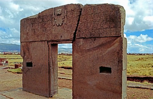
Gateway of the Sun, Tiwanaku
INCA EXPANSION
Lake Titicaca once again became an important locale with the rise of the Inca empire during the 15th and 16th centuries CE.The Incas were immediately attracted to the altiplano as a possible area of expansion but it did take them some time to conquer the Titicaca basin and its local cultures, the Lupaqa, Qolla and Ayaviris. The first expansion in the area occurred in the reign of Viracocha Inka from 1425 CE and then again under Pachacuti Inca Yupanqui (1438-1471 CE). However, it was the decisive victory, at the Desaguadero river which flows from the lake on the southern side, which finally ensured Inca control and brought ruthless reprisals on the local chiefs - their heads were displayed on poles and their bodies skinned to make drums. Reportedly, the Qolla leader was taken to Cuzco and, in a great ceremony, beheaded for his troubles.
The Lupaqa, Qolla, and Ayaviris probably had not advanced to a level of state organization by the time the Inca arrived and, by 1532 CE, a series of alliances between the locals and their Inca overlords had established 13 provinces around the lake. The subjugation of the cultures around Titicaca was completed by forced resettlement and employment elsewhere in the empire and by the prohibition of settlement in fortified hilltop sites. Lupaqa architecture and burial practices, in particular, came to display the familiar traits of Inca architecture - rectangular floor plans and well-dressed stonework.
The Incas incorporated the local myths concerning the lake into their own history by adopting it as a sacred site with temples to the sun ( Inti ) and moon (Coati) constructed on islands on the lake, the building of a sanctuary on the Copacabana promontory, the setting aside of land for the sun god Inti on the northern shores, and the veneration of the ancient ruins of Tiwanaku on the southern shore. The Inca founder leaders, which included Manco Capac and his sister (or wife) Mama Ocllo, were thought to have come from the lake area and successive Inca rulers would also make annual pilgrimmages to these sacred sites.
ARCHAEOLOGICAL REMAINS
At Chucaripupataon, on the Island of the Sun on the lake, artefacts made with copper, silver, and gold have been excavated and include a gold mask. It was also here that the sacred rock of Titikala was located. Remains of various buildings have been excavated on the two sacred islands. One such structure is a two-storey residential building known as Pilco Kayma and another, known, rather grandly, as the 'Palace of the Virgins of the Sun', is traditionally dated to the reign of Thupa Inca Yupanqui (last quarter 15th century CE). The two-storey complex has six symmetricaly arranged apartments, a courtyard, and a 40 metre long open terrace on the upper floor. The building has the typical features of Inca architecture - trapezoid shapes, well-cut and close-fitting masonry, and walls with niches.
MAP
Zapotec Civilization › Antique Origins
Definition and Origins

The Zapotecs, known as the 'Cloud People', dwelt in the southern highlands of central Mesoamerica, specifically, in the Valley of Oaxaca, which they inhabited from the late Preclassic period to the end of the Classic period (500 BCE - 900 CE). Their capital was first at Monte Albán and then at Mitla, they dominated the southern highlands, spoke a variation of the Oto-Zapotecan language, and profited from trade and cultural links with the Olmec, Teotihuacan and Maya civilizations.
ORIGINS & DEVELOPMENT
The Zapotecs grew from the agricultural communities which grew up in the valleys in and around Oaxaca. In the Preclassic period they established fruitful trade links with the Olmec civilization on the Gulf Coast which allowed for the construction of an impressive capital site at Monte Albán and for the Zapotec to dominate the region during the Classic period. The city, strategically placed overlooking the three main valleys, evolved over centuries, beginning around 500 BCE and remaining the cultural centre until the demise of the civilization around 900 CE.
ZAPOTEC CITIES SHOW A HIGH LEVEL OF SOPHISTICATION IN ARCHITECTURE, THE ARTS, WRITING AND ENGINEERING PROJECTS.
The Zapotec had other significant settlements besides the capital and over 15 elite palaces have been identified in the surrounding valleys. Indeed, the Zapotec may be divided into three distinct groups: the Valley Zapotec (based in the Valley of Oaxaca), the Sierra Zapotec (in the north), and the Southern Zapotec (in the south and east, nearer the Isthmus of Tehuantepec). The major Zapotec sites, spread across the Y-shaped Valley of Oaxaca, include the capital Monte Albán, Oaxaca, Huitzo, Etla, San Jose Mogote, Zaachila, Zimatlan, Ocotlan, Abasolo, Tlacolula, and Mitla. The latter would become the most important Zapotec city from c. 900 CE and is notable for its buildings arranged around plazas which are richly decorated with reliefs of geometrical designs.
By the late Preclassic period Zapotec cities show a high level of sophistication in architecture, the arts, writing and engineering projects such as irrigation systems. For example, at Hierve el Agua there are artificially terraced hillsides irrigated by extensive canals fed by natural springs. Evidence of contact with other Mesoamerican cultures can be seen, for example, at the site of Dainzu, which has a large stone-faced platform with reliefs showing players of the familiar Mesoamerican ball game wearing protective headgear. We also know of very close relations between the Zapotec and the peoples based at Teotihuacan in the Basin of Mexico. Indeed, at Teotihuacan there was even a quarter of the city specifically reserved for the Zapotec community.

Cocijo
RELIGION
The Zapotec pantheon is as rich and bewildering as any other Mesoamerican religion is to modern eyes with the standard deities for such important agencies on the human condition as rain, sun, wind, earth, and war. Some of the most important gods were the Bat-god - the god of corn and fertility, Beydo - god of seeds and wind, Cocijo (who had a human body with jaguar and serpent features with a forked tongue) - the rain and lightning god, Pitao Cozobi - the corn god, Copijcha (symbolised by the macaw) - the god of the sun and war, Coquebila - god of the earth's centre, Huechaana - a mother goddess also associated with hunting and fishing, Kedo - god of justice, Ndan - the androgynous god of the oceans, Pixee Pecala the god of love, and Coqui Xee - the creator god who represented infinity.
In addition, individual cities often had their own patron deities, for example, Coquenexo ('Lord of Multiplication') patron of Zoquiapa, Coqui Bezelao and Xonaxi Quecuya (gods of death and the underworld) patrons of Mitla and Teocuicuilco, and Cozicha Cozee (another war god) patron of Ocelotepec.
Offerings, prayers and sacrifices were offered to these deities in the hope of their favourable intervention in human affairs, for example, to bring rain vital for crops, to end droughts or bring fertility to the land and its population. Also, in common with other Mesoamerican cultures, the Zapotec had 20 day names represented by various glyphs such as Chilla (crocodile), Pija (drought) and Xoo (earthquake); once again they often represent the fundamental elements that could drastically affect daily life.
MONTE ALBÁN
Built on a series of mountain plateau at an altitude of 400 m, the city of Monte Albán was the residential, ritual and economic centre of the Zapotec civilization. It replaced, between 500 and 450 BCE, San José Mogote as the most important settlement in the Valley. It also became the burial site of Zapotec kings for over a thousand years. The city particularly flourished in the late Preclassic period when its population was as high as 20,000 people and again between 400 and 700 CE when the population rose to 25,000 and the city ruled over some 1,000 settlements spread across the Valley.
The majority of the structures visible today on the main plaza date to the Classic period with the notable exception of the Temple of the Danzantes, a stone platform structure which was constructed when the site was first occupied (Monte Alban I).The name Danzantes derives from the dancing relief figures decorating the platform. 300 figures are identifiable, some seem to be old, single-toothed males, some have been mutilated, whilst still others seem to be almost swimming - who they represent is not known. Other relief stones from the temple also provide the first certainly identified written texts in Mexico showing an alphabet with semantic and phonetic elements (as yet undeciphered). There is also a system of numbers represented by dots and bars and glyphs for the 260-day year based on 20 day names and 13 numbers with the 52-year cycle of the Calendar Round.
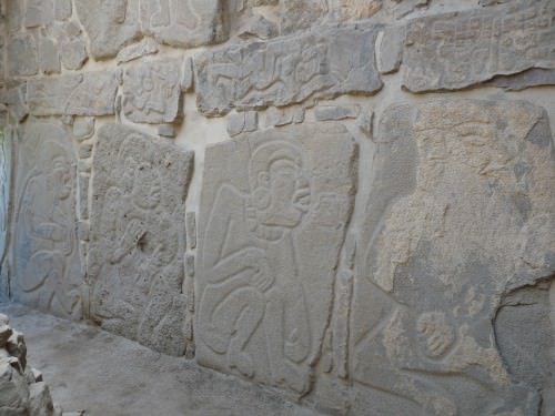
Danzantes, Monte Alban
Finds at the site from this period include a large quantity of pottery, usually made with a fine grey clay, sometimes with incised figures similar to the Danzantes, and typically in the form of spouted vases and bowls set on a tripod. Another interesting type is the whistling jar, a jar with two chambers which when used to pour liquid, expelled air from the second chamber to create a whistling sound. The Zapotec were also skilled sculptors and single effigy figures, groups of figures and urns survive both in clay and more precious goods such as jade.
The city further developed between 150 BCE and 150 CE to create Monte Albán II. Dating from this phase is a large stone-faced building shaped like an arrow head (Building J) which points southwest and is aligned with the Capella star. The building is covered with carved text and reliefs which indicate regional conquests, illustrated by the upside down heads of defeated kings.
In the subsequent Classic period Monte Albán III arose and, influenced by Teotihuacan, saw the construction of an I-shaped ball court and the Temple-Patio-Altar complex that would be copied at sites across the Valley. In addition, over 170 underground tombs have been excavated, many with vaults and antechambers with richly painted walls, which attest to the wealth of the city. The tombs also show signs of being regularly re-opened, illustrating the Zapotec preoccupation with ancestor worship.

Zapotec Double-chambered Vessel
DECLINE
Quite why the city and the Zapotec civilization collapsed at Monte Albán is not known, only that there is no trace of violent destruction and that it was contemporary with the demise of Teotihuacan and a general increase in inter-state conflict. The site continued to be significant, though, as it was adopted by the later Mixtec as a sacred site and place of burial for their own kings. The Zapotecs did not disappear completely, however, for in the early Post-Classic period they established a new, smaller centre at Mitla, known to them as Lyobaa or 'Place of Rest' which also had many fine buildings including the celebrated Hall of the Columns. The site continued to be occupied even up to the Spanish conquest.
LICENSE:
Article based on information obtained from these sources:with permission from the Website Ancient History Encyclopedia
Content is available under License Creative Commons: Attribution-NonCommercial-ShareAlike 3.0 Unported. CC-BY-NC-SA License