Kingdom of Nabatea › Ancient Jordan › Ancient Armenia » Origins and History
Articles and Definitions › Contents
- Kingdom of Nabatea › Origins
- Ancient Jordan › Origins
- Ancient Armenia › Origins
Ancient civilizations › Historical places, and their characters
Kingdom of Nabatea › Origins
Definition and Origins
The Nabatean Kingdom was a powerful political entity which flourished in the region of modern-day Jordan between the 4th century BCE and c. 106 CE and is best known today for the ruins of its capital city of Petra. Although it is clear that a wealthy community was thriving in the immediate vicinity of Petra by 312 BCE (attested to by the Greek expedition mounted against it), scholars usually date the Nabatean Kingdom from 168 BCE, the date of their first known king, to 106 CE when it was annexed by the Roman Empire under Trajan (98-117 CE).
Nabateans were Arabian nomads from the Negev Desert who amassed their wealth first as traders on the Incense Routes which wound from Qataban (in modern-day Yemen) through neighboring Saba (a powerful trade hub) and on toward Gaza on the Mediterranean Sea. Their constant travel on these routes intimately familiarized them with the area and their skill in finding, and preserving, sources of water enabled them to transport goods more quickly and efficiently than others.
The site of their city of Petra, carved from the sandstone cliffs of mountains and not easily accessible, would have been built after they were already wealthy from trade. Their decision to build in that particular area has mystified scholars and historians for centuries because there was no natural source of water there and the locale was far from hospitable. The location actually makes a great deal of sense, however, as their position at Petra allowed them to monitor the Incense Routes and tax caravans passing through their territory, thus enriching them further, and its inaccessibility provided protection.
Following annexation by Rome in 106 CE, Petra and other Nabatean cities such as Hegra steadily lost their hold over the Incense Routes and their control over the region generally. The rise of the Syrian city of Palmyra as a center of trade diverted caravans from the Nabatean cities which then declined in wealth and prestige. The emperor Aurelian ’s destruction of Palmyra c. 272 CE came too late to resuscitate the Nabatean economy, and by the time of the Arab Invasion of the 7th century CE, the Nabatean Kingdom had been forgotten.
SPONSORSHIP MESSAGE
EARLY TRADE ON THE INCENSE ROUTES
The term 'Incense Routes' refers to a number of different directions traders took between southern Arabia and the port of Gaza between the 7th/6th centuries BCE and the 2nd century CE. Trade along these routes seems to have become most lucrative c. 3rd century BCE by which time the Nabateans had control of the most important cities along the routes. The Incense Routes do not describe a single road or roads between Arabia and Gaza but a general direction merchants traveled between those two points. According to Pliny the Elder (23-79 CE), the routes encompassed 1,200 miles (1,931 km) and took 65 days to travel one way with a stopover at a city, ideally, every night.
THE CITIES CONTROLLED BY THE NABATEANS BY THE 3RD CENTURY BCE HAD BECOME SUCH AN INTEGRAL PART OF TRADE ALONG THE ROUTES THAT THEY COULD NOT BE AVOIDED.
These stops were not merely for rest but were an important aspect of business. The city of Mamshit, for example, was famous for their Arabian horses which commanded high prices. Merchants would therefore move from city to city, trading their goods at each stop before reaching the final destination of the port at Gaza. As certain cities began taxing merchants more heavily, trade would veer toward others which were considered more hospitable. The cities controlled by the Nabateans by the 3rd century BCE, however, had become such an integral part of trade along the routes that they could not be avoided.
Among these cities were those which would become known as Haluza, Mamshit, Avdat, and Shivta all of which offered goods for trade as well as comfortable accommodations for the traders. Nabatean forts erected along the routes guaranteed the safety of the merchants but, as with the tax they levied on traders, their protection came at a price. Although the Nabateans were already quite wealthy by the 3rd century BCE as traveling merchants, they became more so through their tight control of the Incense Routes once they had established their kingdom.
WEALTH, CUSTOMS, WOMEN'S RIGHTS
It is thought that they were able to become so successful through their early control of water along the routes. While other Arabian tribes had to barter for water, the Nabateans dug cisterns which filled with rainwater and then covered them and left signs which only they would recognize. Following this policy, they were able to travel with greater ease than their competition in trade. They were also able to solve the problem of water for Petra through technological ingenuity. The Nabateans orchestrated an elaborate system of water transportation and conservation which was unrivaled in its day and has not yet been surpassed in the region. The area is subject to flash floods, and through a careful construction of dams, cisterns, and aqueducts, the Nabateans were able to create an artificial oasis in an arid district which not only sustained them but elevated them to the most powerful kingdom in the region.
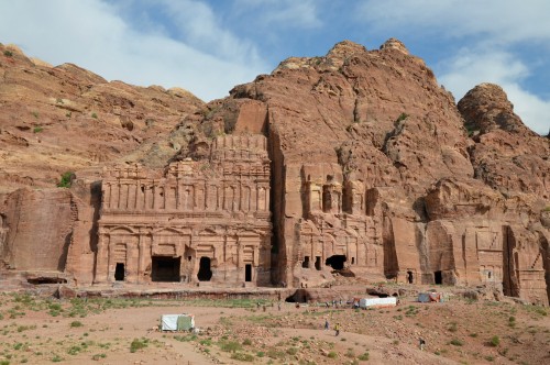
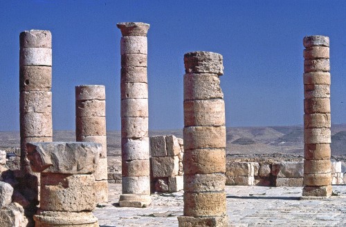
Nabataean Tombs of Petra
Precisely when cities like Petra and Hegra were constructed is unclear but they were well established by the later 4th century BCE when the wealth of the Nabateans attracted the attention of the Greek general (and future king) Antigonus I (r. 306-301 BCE). In 312 BCE, Antigonus pretended friendship with the Nabateans and then sent his son Demetrius in a surprise attack on Petra. The Nabateans had not been fooled, however, and were prepared for Demetrius. His offensive failed and he came to terms with the Nabateans and returned to his father; both were driven from the region by the Nabateans in a later engagement.
The immense wealth of the Nabatean Kingdom grew and became legendary in its own time. Centuries later, it was still mentioned by historians such as Strabo (died c. 23 CE) and Diodorus Siculus (1st century BCE). These two writers, as well as others, portray the Nabateans uniformly in a positive light. Diodorus addresses the wealth of the Nabateans, as well as their customs, in Book XIX of his Histories :
For the sake of those who do not know, it will be useful to state in some detail the customs of these Arabs, by following which, it is believed, they preserve their liberty. They live in the open air, claiming as native land a wilderness that has neither rivers nor abundant springs from which it is possible for a hostile army to obtain water.It is their custom neither to plant grain, set out any fruit-bearing tree, use wine, nor construct any house; and if anyone is found acting contrary to this, death is his penalty.They follow this custom because they believe that those who possess these things are, in order to retain the use of them, easily compelled by the powerful to do their bidding. Some of them raise camels, others sheep, pasturing them in the desert. While there are many Arabian tribes who use the desert as pasture, the Nabataeans far surpass the others in wealth although they are not much more than ten thousand in number; for not a few of them are accustomed to bring down to the sea frankincense and myrrh and the most valuable kinds of spices, which they procure from those who convey them from what is called Arabia Eudaemon [“Fortunate Arabia”, modern-day Yemen].They are exceptionally fond of freedom; and, whenever a strong force of enemies comes near, they take refuge in the desert, using this as a fortress; for it lacks water and cannot be crossed by others, but to them alone, since they have prepared subterranean reservoirs lined with stucco, it furnishes safety.As the earth in some places is clayey and in others is of soft stone, they make great excavations in it, the mouths of which they make very small, but by constantly increasing the width as they dig deeper, they finally make them of such size that each side has a length of one plethrum [101 ft/30 metres].After filling these reservoirs with rain water, they close the openings, making them even with the rest of the ground, and they leave signs that are known to themselves but are unrecognizable by others.They water their cattle every other day, so that, if they flee through waterless places, they may not need a continuous supply of water. They themselves use as food flesh and milk and those of the plants that grow from the ground which are suitable for this purpose; for among them there grow the pepper and plenty of the so‑called wild honey from trees, which they drink mixed with water. (XIX.94.2-10)
Strabo presents a similar picture of the Nabateans but contradicts Diodorus on the custom of drinking wine, claiming that they cultivated grapes for wine and drank at banquets. He does make the point, however, that they did not drink to excess like the Romans did but restricted themselves to no more than eleven cups in the course of an evening (Geography XVI.4.26). He further details how they used camels instead of horses, wore loincloths instead of tunics, and were so democratic that their king would insist on serving others at a banquet.
Women were considered equal to men in Nabatean culture. Inscriptions indicate that women were priestesses, co-rulers or autonomous monarchs, could inherit and dispose of property, owned their own tombs, brought lawsuits and represented themselves in court, and were depicted on coins. Some of the most popular deities in the Nabatean pantheon were female such as Al-'Uzza, Manawat, and Allat.
NABATEAN RELIGION
Nothing is known of the religious practices of the Nabateans except that they were polytheistic and worshiped the sun in ceremonies conducted on the tops of temples and honored their gods in private ceremonies in the home. There was a priestly class which was open to both men and women, but how one was chosen or what one's preparation for the priesthood may have been is unknown. It is likely that, as in Egypt, the priests and priestess tended to the gods, not the people, and there does not seem to be any institution of public worship services other than festivals.
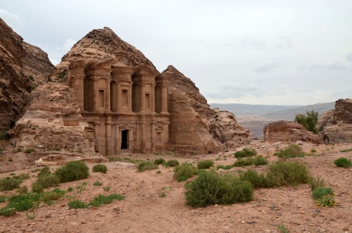
The Monastery in Petra
The gods of the Nabatean pantheon were never represented in full-scale statuary but appear carved into doorways, in the nooks of temples, on coins, tombs, ceramics, and as amulets and charms. The three most important gods in the early years of the culture were:
Al-Qaum - god of war, protector of the people, god of nighttime, protector of souls
Al-Kutby - god of knowledge, writing, and divination
Al'Uzza - supreme mother goddess, associated with divine and earthly power
Later deities were Manawat (goddess of fate and fertility), Allat (goddess of renewal, spring, and fertility), and Dushara (also given as Dushares, god of the mountains and daytime, associated with the sun). Of all these deities, Dushara endured the longest and was the deity worshiped from the rooftops of Nabatean temples. He was still represented on coinage following the annexation of Nabatea by Rome.
THE NABATEAN KINGS & CONFLICTS
The Nabateans were literate and developed the Arabic script but they wrote nothing of their own history. The story of their culture, customs, and kings was written by Greek and Roman writers and is suggested by their architecture, art, and brief inscriptions they left behind. As their kingdom developed, the Nabateans came into closer contact and conflict with those of the surrounding regions and their kings are mentioned increasingly by writers from those nations.
There was an early king possibly named Rekem or Raqmu for whom the city now known as Petra was named. Petra (from the Greek for “rock”) was the Greek name for the Nabatean capital of Raqmu. When this early king lived and reigned is as mysterious as the date when Petra was carved from the cliff sides. The first historically attested king is Aretas I (c. 168 BCE) and his reign marks the beginning of the Nabatean Kingdom.
Aretas I's date is attested by a Nabatean inscription citing 168 BCE and he is also mentioned in the biblical Book of II Maccabees (5:8) which confirms his reign at that time. He expanded the territory of Nabatea and was known as “the Tyrant of the Arabs” by his enemies. He supported the Maccabees of Judea in their struggle against the Seleucid Greeks (c.168/167-c.160 BCE) and allowed the forces of Judas Maccabeus to conduct raids from his territory.
The next Nabatean monarch - said to have succeeded Aretas I but most likely a later king - is known as Aretas II (also as Erotimus, rc 120/110-96 BCE). Aretas II came into conflict with the Hasmonean Dynasty installed by the Maccabees owing to the Judean policies of expansion. The Hasmonean king Alexander Janneus (r. 103-76 BCE) destroyed Gaza and took control of the terminus of the Incense Routes, infringing on Nabatean profits.
Aretas II's successor, Obodas I (c. 96-85 BCE) defeated Janneus in battle and reclaimed Gaza. He then defeated the Seleucid Greeks under Antiochus XII Dionysius (87-84 BCE), killing the king and scattering his army. After this victory, he was deified by his people as attested by a memorial at his grave in the city of Avdat. He was succeeded by his brother Rabbel I (c.85 BCE) who was killed in battle and the throne passed to another brother who took the throne name Aretas III (c. 85-60 BCE).
Avdat
Aretas III enlarged Nabatean territory to its greatest extent, controlling trade routes from Syria across Arabia toward the southern coast. In 64 BCE the Roman general Pompey invaded and took Syria for Rome and his general Scaurus was sent to take Petra. Scaurus had no more success than Demetrius had centuries before, but the Roman army was far more powerful than the earlier Greek forces, and the Nabateans were forced to pay tribute to Rome to retain their independence.
Aretas III was succeeded by Obodas II (c. 60-59 BCE) who died shortly after coming to power, and the throne passed to Malichus I (c. 59-30 BCE) who was forced to submit to Herod the Great as a vassal. He was succeeded by Obodas III (c. 30-9 BCE) who defended the Nabatean Kingdom against Rome primarily by sending his chief minister Syllaeus to “guide” the Roman army under Gallus toward Nabatean cities. Syllaeus pretended all along to be a sincere friend of the Romans and effortlessly led them astray. He was eventually executed at Rome for treachery.
Obodas III was succeeded by Aretas IV (c. 9 BCE- 40 CE) who is considered the greatest of the Nabatean kings. Nabatean inscriptions record his name as “Aretas, King of the Nabateans, lover of his people” and he was revered as a great monarch.His wife, Chuldu (also given as Huldu, Huldo) reigned with him and possibly on her own after his death. Aretas IV consolidated Nabatean power in the region, even in the face of Roman incursions, and was able to win recognition from Augustus Caesaras an autonomous king. Women's rights, arts, culture, law, and the Nabatean economy all reached their height under his reign.
He was succeeded by his son Malichus II (c. 40-70 CE) who lost territories to Rome and tried, unsuccessfully, to win Roman respect by sending Nabatean forces to help the Romans put down the Jewish Revolt against Roman rule in 66-70 CE. He died, or was killed, and was succeeded by Rabbel II Soter (c. 70-106 CE), known as the savior of his people even though he lost more territory to Rome and Nabatean prestige declined under his reign. He was briefly succeeded by his sister Gamilath, but the Nabatean Kingdom had run its course by this time as Rome grew in power, and the region as annexed as the Roman province of Arabia Petrea in 106 CE.
CONCLUSION
The cities of the Nabateans declined under Roman rule and an earthquake in c. 363 CE brought down many of them. The region was controlled by the Eastern Roman (Byzantine) Empire which established churches in the cities and revitalized commerce until another earthquake in c. 551 CE resulted in further widespread destruction. By the time of the Arab Invasion in the 7th century CE, the cities had long been deserted and the Nabateans forgotten.
It was only in the 19th century CE, when European explorers began to visit the area, that cities like Petra were rediscovered and the Nabatean culture attracted attention through the city of Petra. Interest in the Nabateans grew during the 20th century CE with a number of scholars and archaeologists visiting the region and excavating the ancient sites. Petra was declared a World Heritage Site in 1985 CE and chosen as one of the New Seven Wonders of the World in 2007 CE.
The Nabateans' skill in masonry, clearly evident in the extant structures of Petra, was unmatched in the ancient world, and their abilities to make the most out of any opportunity enabled them to become the wealthiest kingdom in the region. Although forgotten for centuries, the Nabateans are today recognized as a highly developed culture who were able not only to endure the harsh climate of the region but to thrive in it.
Ancient Jordan › Origins
Definition and Origins

Jordan is a country in the Near East bordered by Israel, Syria, Iraq, and Saudi Arabia which was part of the Land of Canaan in ancient times. The country is named for the River Jordan which flows between modern-day Jordan and Israel and whose name means "to descend" or "flow downwards". The region has a long history as an important trade center for every major empire from the ancient world to the present age (the Akkadian to the Ottoman empire) and numerous sites in the country are mentioned throughout the Bible.
Alexander the Great (r. 336-323 BCE) founded cities in the region (such as Gerasa) and the Nabateans carved their capital city of Petra there from sandstone cliffs. Early in its history the area attracted and inspired traders, artists, philosophers, craftsmen and, inevitably, conquerors all of whom have left their mark on the history of the modern-day country.
Jordan, formally known as The Hashemite Kingdom of Jordan, has been an independent nation since 1946 CE after thousands of years as a vassal state of foreign empires and European powers and has developed into one of the most stable and resourceful nations in the Near East. Its capital city, Amman, is considered one of the most prosperous in the world and a popular destination for tourists. The history of the region is vast, going back more than 8,000 years, and encompassing the tale of the rise and fall of empires and the evolution of the modern state.
JERICHO, CLAIMED TO BE THE OLDEST CONTINUOUSLY INHABITED CITY IN THE WORLD, HAS AN APPROXIMATE FOUNDING DATE OF 9,000 BCE.
EARLY HISTORY
Archaeological excavations date human habitation in the region of Jordan back to the Paleolithic Age (around two million years ago). Tools such as stone hand-axes, scrapers, drills, knives, and stone spear points, dated to this time period, have been found in various locations throughout the country. The people were hunter-gatherers who led a nomadic life moving from place to place in search of game. In time, they began building permanent settlements and establishing agricultural communities.
The Neolithic Age (c. 10,000 BCE) saw the rise of stable, sedentary communities and the growth of agriculture. These small villages eventually became urban centers with their own industry and initiated trade with others. Large urban centers developed such as the city of Jericho, claimed to be the oldest continuously inhabited city in the world, with an approximate founding date of 9,000 BCE.
According to scholar G. Lankester Harding:
[Cities like Jericho provide evidence of] far higher culture than we had hitherto suspected, for here was not merely a village of well-built houses with fine plaster floors, but there was a great stone wall all around the settlement with a ditch or dry moat in front of it. This implies a high degree of communal organization, of subordinating the personal interests to those of the many. (29)
Communal interests are also evident in the ancient monuments raised at this time. Throughout the Neolithic Age the people constructed megalithic dolmens across the land (very similar in size, shape, and methods used to those of Ireland ). These dolmens are thought to be monuments to the dead or possibly passageways between worlds. These dolmens are often found in fields of circled stones whose meaning remains unclear but it is obvious that the builders would have had to work in groups for a common cause to create these sites.
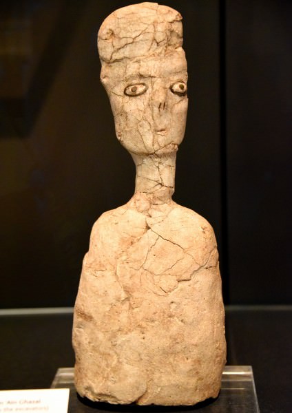
Lime Plaster Statue from Ain Al-Ghazal
The dolmen sites were most likely religious in nature and visited for worship, divination, and festivals by the people of the nearby cities. The largest settlement of the Neolithic Age in Jordan was Ain Ghazal located in the north-west (near the present-day capital of Amman). Inhabited c. 7000 BCE, Ain Ghazal was an agricultural community whose artisans created some of the most striking anthropomorphic statuary in early history. The statues found at Ain Ghazal are among the oldest, if not the oldest, in the world today.
The community had over 3,000 citizens and engaged in trade and the manufacture of pottery which increased the wealth of the people individually and the city collectively. Ain Ghazal continued as a prosperous settlement for 2,000 years between c.7,000 BCE and 5,000 BCE when it was abandoned, most likely due to overuse of the land.
THE HYKSOS & EGYPTIANS
The Chalcolithic and Bronze Ages (c. 4500-3000 and 3000-2100 BCE, respectively) saw further developments in architecture, agriculture, and ceramics. The Ghassulian Culture, centered around the site of Talailat Ghassul in the Jordan Valley, rose to prominence in the Chalcolithic Age displaying inordinate skill in smelting copper, ceramics, and intricacies in architectural design.
The Bronze Age settlement of Khirbet Iskander (founded c. 2350 BCE) rose by the banks of the Wadi Wala stream and was a prosperous trading community until the arrival of invaders who destroyed towns, villages, and cities throughout Jordan in c.2100 BCE. The identity of these aggressors is unknown but they were most likely the armies of the Gutians whose invasions toppled the Akkadian Empire founded by Sargon the Great (r. 2334-2279 BCE) beginning in c. 2193 BCE; the region of Jordan, of course, was part of this empire. The Sea Peoples have been suggested as the invaders by some scholars but the date is too early for their incursions in the area.
Whoever they were, these invaders were then driven out by another group who migrated to the area (possibly as early as 2000 BCE), the Hyksos, who brought a completely different culture to Jordan and established themselves as the ruling class. In time, the Hyksos of Jordan would amass enough power to conquer Egypt and would hold both countries until driven out by the Egyptians in c. 1570 BCE by Ahmose I (c. 1570-1544 BCE). Some scholars argue that the Hyksos (so-called by the Egyptians; the name by which they called themselves is unknown) were indigenous to Jordan while others claim they were foreign invaders; whichever the case, they permanently changed life in Jordan by introducing the horse, composite bow, and chariot to armed conflict, introducing better methods of irrigation, and developing better systems of defense for walled cities.
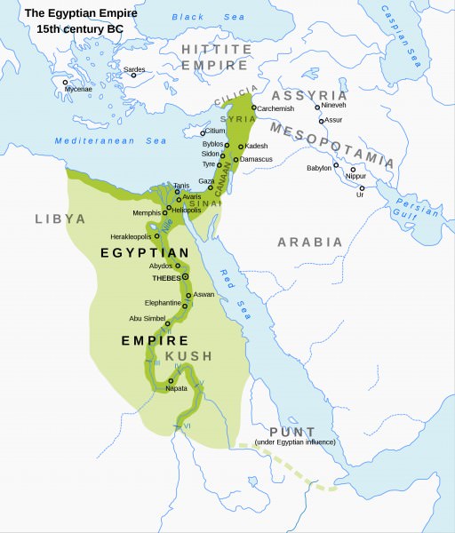
Map of the New Kingdom of Egypt, 1450 BCE
The region of modern-day Syria, Jordan, Lebanon, and Israel (the Levant ) were in continuous trade with other areas and civilizations throughout these periods. Writing in Mesopotamia developed c. 3500 BCE as a means of long-distance communication in trade and yet these regions, which were literate from at least 3000 BCE, did not adopt a system of writing until c. 2000 BCE for reasons which are unclear. Inscriptions such as signs and symbols were created but no complete scriptseems to have been formulated. Writing did not develop in Jordan until after the Egyptians had overthrown the Hyksos in c.1570 BCE.
THE REGION FLOURISHED TO SUCH A GREAT DEGREE THAT IT WOULD BE REFERRED TO IN THE BIBLE AS A GLORIOUS LAND “FLOWING WITH MILK & HONEY”.
Once the Hyksos were driven out of Egypt, the Egyptians pursued them through Jordan, establishing military posts which grew into stable communities. Under the later reign of the Egyptian Queen Hatshepsut (1479-1458 BCE) and her successor Thuthmose III (1458-1425 BCE), trade flourished. Thuthmose III established Egyptian rulers throughout the larger region of Canaan bringing stability, peace, and prosperity. The region flourished to such a great degree that it would be referred to as a glorious land “flowing with milk and honey” centuries later in various books of the Bible.
JORDAN IN THE BIBLE & THE IRON AGE
The cities of Gerasa and Gadara (modern-day Jerash and Umm Qais, respectively) are mentioned in the Book of Mark 5:1-20 and the Book of Matthew 8:28-34. Both of these passages relate the story of Jesus driving evil demons from possessed people into a herd of pigs. The story in Mark, considered the earlier of the two, places the event in Gerasa while Matthew's version has it in Gedara. Mark mentions how, after the miracle, the man who had been demon-possessed relates the miracle to all the people of the Decapolis; the Decapolis was the term for the ten cities on the eastern edge of the Roman Empire at that time and both Gerasa and Gadara were among them.
The region of modern-day Jordan is mentioned a number of times in the Bible's Old Testament as part of the narratives which make up the books of Genesis, Exodus, Deuteronomy, Numbers, Joshua, and others concerning the land of the Israelites, their enslavement in Egypt, and their deliverance to a promised land which then must be conquered. The events related are thought to have occurred during the latter part of the Bronze Age (c. 2000-1200 BCE) although there are discrepancies between the biblical accounts and the archaeological record.
Among the discrepancies most frequently noted by scholars is the fact that the region of Jordan mentioned in the books of Exodus, Numbers, and Joshua is clearly inhabited while the archaeological record indicates a largely unoccupied country. The battles said to have been fought by the Hebrews in Numbers and in Joshua also seem to have left behind no archaeological record. It should be noted, however, that the city of Jericho, famous for its fall to Joshua (Joshua 6:1-27), does show evidence of a violent destruction c. 1200-1150 BCE during the Bronze Age Collapse.
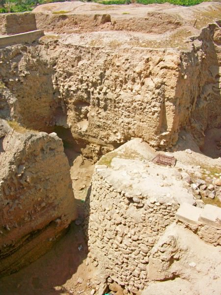
Walls of Jericho
Mount Nebo in Jordan is the spot where Moses is said to have been allowed a glimpse of the Promised Land before he died (Deuteronomy 43:1-4) and Jordan was the land of the Midianites where Moses took refuge after his flight from Egypt in Exodus (Exodus 2:15) and the region in which he encountered the burning bush which sent him back on his mission to free his people from bondage (Exodus 3:1-17). He is said to be buried on Mount Nebo, originally a site sacred to the Moabites and their gods.
The beginning of the Iron Age (c. 1200-330 BCE) in the region was initiated by the invasion of the Sea Peoples, a mysterious culture whose identity scholars still debate. Some have claimed they are the Philistines of the Bible while others have suggested they were Etruscan, Minoan, Mycenaean, or other nationalities. No single claim identifying them has been widely accepted nor is it likely one will be in the near future as the extant inscriptions available only state that these people came from the sea, not which sea nor even from which direction.
The Sea Peoples arrived on the coast of Canaan c. 1200 BCE with an advanced knowledge of metallurgy and their iron weapons were far superior to the stone and copper blades and spears of their opponents. While the Sea Peoples were invading from the south, the biblical record tells of great battles between the Israelites and the Moabites and Midianites in the Book of Judges as well as raids on Israelite settlements by the Ammonites from northern Jordan. The Jordanian kingdoms of Edom in the south, Moab in the center, and Ammon in the north all grew in power during this time.
The Mesha Stele (also known as the Moabite Stone, c. 840 BCE) records a battle fought between Mesha, king of Moab, and three kings of Israel. The narrative on the stele corresponds to the account of the event given in II Kings 3 in which Joram of Israel and Jehosophat of Judah go to war to put down a Moabite rebellion. The Mesha Stele is among the best-known artifacts corroborating a biblical narrative even though some scholars have questioned its meaning and even its authenticity.
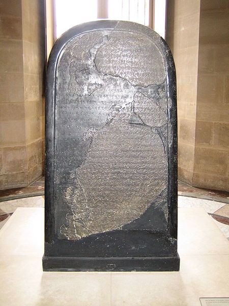
Mesha Stele
The dispute over whether the Mesha Stele supports the biblical narrative is typical of arguments over interpretation not only of objects but of ancient texts. Those scholars who equate the Sea Peoples with the Philistines interpret the Books of I and II Samuel, which significantly feature the Philistines, as a narrative of the Sea Peoples. These books tell the story of the rise of King Saul (c.11th century BCE) over the Israelites and David's defeat of the Philistines in slaying their champion, Goliath, in single combat.
Most of what is known of the Sea Peoples comes from Egyptian records which claim that they were defeated by Rameses III in 1178 BCE near the Egyptian city of Xois and, afterwards, they vanish from the historical record. If this claim, along with Saul's and David's traditional dates, is accepted then the Philistines could be the Sea Peoples who invaded Egypt following their battles with Saul and David. This is far from certain, however, and no consensus on this subject has been reached.
Scholarly agreement is also divided on whether the Sea Peoples were responsible for the devastation of cities throughout the region of Canaan or whether this was the result of the general Joshua and his campaigns of conquest in the region, claiming it as the promised land for his people (books of Numbers and Joshua). Either way, the introduction of iron weapons to the region changed the dynamics of battle, favoring those armed with them, as the Assyrian military machine proved when they took the country. The Assyrians were considered invincible in battle; largely due to their superior weaponry.
THE GREAT EMPIRES & THE NABATEANS
The Assyrian Empire, and its continuation the Neo-Assyrian Empire, both employed iron weapons in conquest and became the greatest and most extensive political power in the world up to that time. Under the Assyrian king Tiglath Pileser I (1115-1076 BCE) the region of the Levant was firmly taken under Assyrian control and would remain part of the empire until its fall in 612 BCE.
The Babylonian Empire then took possession of the land until it was taken by Cyrus the Great, founder of the Achaemenid Empire (549-330 BCE), also known as the Persian Empire, which then fell to Alexander the Great in 331 BCE and became part of his emerging empire. Prior to Alexander's invasion, a unique culture grew up in Jordan whose capital city has become one of the most recognizable images from the ancient world and a popular tourist attraction in the present day: the Nabateans and their city of Petra.
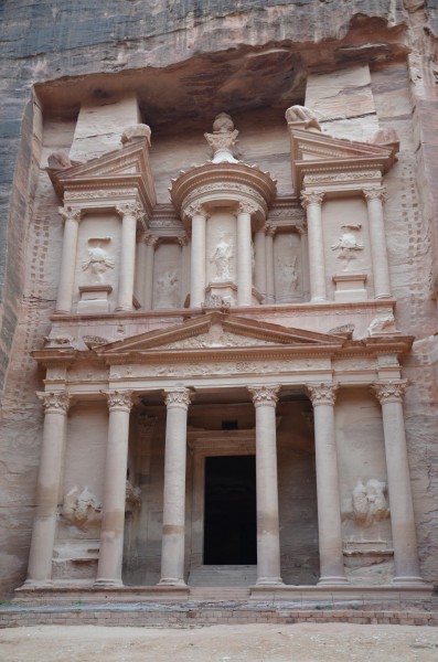
The Treasury, Petra
The Nabateans were nomads from the Negev Desert who arrived in the region of modern-day Jordan and established themselves sometime prior to the 4th century BCE. Their city of Petra, carved from sandstone cliffs, may have been created at this time but possibly earlier. The Nabateans initially gained their wealth through trade on the Incense Routes traveling between the Kingdom of Saba in southern Arabia and the port of Gaza on the Mediterranean Sea. By the time they had established Petra, they were also in control of other cities along the Incense Routes and were able to tax caravans, provide protection, and control the lucrative spice trade.
The famous facade of Petra, known today as The Treasury, was almost certainly originally a tomb or mausoleum and, contrary to popular imagination, does not lead into any intricate maze of hallways but only a fairly short and narrow room. The more spacious dwellings which make up the rest of the cliff city attest to the Nabateans' wealth as traders who had enough disposable income and manpower to be able to afford such an intricate and timely construction.
The name `Petra' means 'rock' in Greek ; the city was originally called Raqmu (possibly after an early Nabatean king) and is mentioned in the Bible and in the works of writers such as Flavius Josephus (37-100 CE) and Diodorus Siculus (1st century BCE). At the height of the Nabatean Kingdom, the Jordan region enjoyed great prosperity and not only in and around the city of Petra. The Nabateans were certainly the wealthiest but people of other nationalities shared in their good fortune as well.
Nabataean Tombs of Petra
In c. 200 BCE the governor of Ammon, Hyrcanus, had his elaborate fortress-palace Qasr Al-Abd ("Castle of the Servant") built which would have required a huge amount of disposable income. Flavius Josephus describes the palace (which he understood as a fortress) in glowing terms as “built entirely of white stone” on a grand scale, including a large reflecting pool, and how its walls were carved with "animals of a prodigious magnitude" as well as banquet halls and living quarters supplied with running water (Merrill, 109). Ruins of this structure survive today near Araq al-Amir, although in a greatly diminished state from Josephus' time, but still attesting to the wealth and vision of the man who commissioned it.
The first historically attested king of the Nabateans was Aretas I (c. 168 BCE) and so, although the Nabateans had established themselves in the region centuries before, the Kingdom of Nabatea is dated from 168 BCE to 106 CE when it was annexed by Rome. The Nabateans had a highly developed culture in which art, architecture, religious sensibilities, and trade all flourished. Women had almost equal rights, could serve as clergy, and even reign as autonomous monarchs. The most important deities of the Nabatean pantheon were female and women most likely would have served as their high priestesses.
To solve the problem of a reliable water supply in the arid region, the Nabateans engineered a series of wells, aqueducts, and dams whose efficiency was unrivalled in their day. With access to water, and established in some of the most inaccessible areas of the region, the Nabateans were able to fend off aggressors attracted by their wealth. They could not hold out long against the superior might of Rome, however, which steadily took their territories and absorbed their trade routes until finally taking the entire kingdom and renaming the region Arabia Petrea in 106 CE under the emperor Trajan (98-117 CE).
ROME, ISLAM, & THE MODERN STATE
The Romans revitalized much of the region (although Nabatean cities such as Petra and Hegra were neglected), creating a powerful trade center at Gerasa and another called Philadelphia at the site of Ammon, now Amman, the capital city of modern-day Jordan. The city of Gedara flourished under the Romans. Gedara was the birthplace of the Roman poet and editor Meleager (1st century CE) and had earlier inspired the work of the Epicurean philosopher and poet Philodemus (c. 110-35 BCE). The Romans certainly benefited from the resources of the region, as well as from the recruits they pressed into their armies as conscripts and auxiliaries, but also improved the area as they built roads, temples, and aqueducts which turned large areas of the region into fertile landscape and encouraged prosperous trade. Gerasa became one of the wealthiest and most luxurious provincial cities of the Roman Empire at this time.
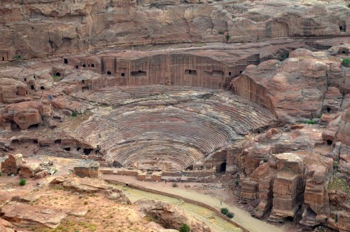
Theatre of Petra
Even so, Rome began to decline steadily throughout the 3rd century CE and faced serious challenges as the 4th century CE began. As Rome struggled with internal difficulties and invasions, the region which would become Jordan suffered along with all the other provinces. The semi-nomadic Tanukhids gained power in and around the area in the 3rd century CE and their most famous leader, Queen Mavia (c. 375-425 CE) led a revolt against Rome, most probably provoked by the empire's insistence on Tanukhid auxiliaries for the army.
As the Tanukhids were originally part of the Nabatean tribal confederacy, it is thought she would have controlled the areas formerly comprising the Kingdom of Nabatea. Whether this is so, she was powerful enough to defy Rome, negotiate a peace on her own terms, and later send cavalry units to assist in the defense of Constantinople following Rome's defeat at the Battle of Adrianople in 378 CE.
When Rome fell in the west (476 CE), the eastern part continued as the Byzantine Empire ruling from Constantinople. In the 7th century CE the Arab Invasion swept across the region, converting the people to Islam, which then brought these people into conflict with the Byzantines. The region of modern Jordan became a part of the Umayyad Empire, the first Muslim dynasty, which ruled from 661-750 CE. Under the Umayyad Empire, Jordan thrived but was neglected by the next ruling house, the Abassids (750-1258 CE) when they withdrew their support from the area, moving the capital from Damascus, just north of Jordan, to Kufa and then Baghdad, significantly further away.
The Fatmid Caliphate (909-1171 CE, which was absorbed by the Abassids) took Jordan during their expansion and initiated renovations of temples, buildings and roads as did the Ottoman Empire (1299-1923 CE) which came after the Abassids. The Ottoman armies defeated the forces of the Byzantine Empire in 1453 CE, ending western influence in the region.
During World War I (1914-1918 CE), the Ottomans sided with Germany and the Central Powers. The Arab Revolt of 1916 CE, which started in Jordan, significantly weakened the Ottoman Empire as it struggled against the Allied Powers and, when they were defeated, the empire was dissolved in 1923 CE. Jordan then became a mandate of the British Empire until it won its independence in 1946 CE following World War II. Today the region is known as the Hashemite Kingdom of Jordan, an autonomous state with a bright future - and a long and illustrious past.
Ancient Armenia › Origins
Definition and Origins

Ancient Armenia, in the south Caucasus area of Eurasia, was settled in the Neolithic era but its first recorded state proper was the kingdom of Urartu from the 9th century BCE. Incorporated into the Persian Empire of Cyrus the Great in the 6th century BCE, the Orontid dynasty ruled as Persian satraps, a function they performed for their next overlords the Macedonians and Seleucid Empire into the 3rd century BCE. Under the Artaxiad and Arsacid dynasties the country flourished but was often caught between the ambitions of Parthia and Rome, and then the Sasanian and Byzantine Empires. The boundaries of the state varied considerably over the centuries but such common factors as religion and language were united by long-lasting dynastic clans, which gave Armenia its own unique identity throughout antiquity.
HAYASA-AZZI (1500-1200 BCE)
The first identifiable culture in the region is the Hayasa-Azzi, an indigenous tribal confederation which flourished on the fertile plateau of ancient Armenia around Mount Ararat and parts of modern-day eastern Turkey between c. 1500 and c. 1200 BCE.The Hayasa-Azzi are the eponym of the Hay people, the term Armenians use to describe themselves and their state, Hayastan. Over time, the Hayasa-Azzi mixed with other ethnic groups and local tribes such as the Hurrians, Arme-Shupria, and Nairi, probably motivated by the need for defence against more aggressive and powerful neighbours like the Hittites and the Assyrians. They were probably infiltrated by the Thraco-Phrygians following the collapse of the Hittite Empire c. 1200 BCE. Eventually, these various peoples and kingdoms would be fused into the region's first recognisable and recorded state, the kingdom of Urartu from the 9th century BCE.
URARTU (9TH CENTURY BCE - C. 590 BCE)
Names
Urartu, also known as the Kingdom of Van after the lake in the region of the same name, developed as a federation of older and smaller kingdoms across Armenia, eastern Turkey, and northwestern Iran. 'Urartu' comes from urashtu, the Assyrian word for the kingdom, and signifies “high place”, possibly referring to either the mountainous region or the culture's common practice of building fortifications on rock promontories. The Urartians called themselves the Biaina.
Geography & Expansion
Urartu prospered thanks to settlement on the extensive fertile plateau which was well-supplied by rivers. Viticulture was important, wine-making in the region perhaps being the earliest anywhere. Animal husbandry prospered thanks to excellent mountain pastures, and horses, especially, were bred with success. Mineral deposits in the area included gold, silver, copper, lead, iron, and tin and were all used to produce highly skilled metalwork, especially bronze cauldrons. The location on the trade routes between the ancient Mediterranean and Asian and Anatolian cultures was another source of prosperity.
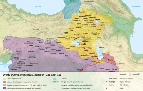
Urartu 714-715 BCE
The fortress capital was Tushpa (later called Van), built on a limestone promontory on the eastern shores of Lake Van in the highlands. Regional governors represented the king and channelled taxes back to the capital. In 776 BCE, Argishti I (rc 785-760 BCE) founded a new city, Argishtihinili, on the Plain of Ararat, later to become the second city of the kingdom and renamed Armavir. Then, c. 685 BCE, king Rusa II (rc 685-645 BCE) founded the important northern city of Teishebaini(modern Yerevan), also on the Ararat plain. An important fortress site with substantial remains today is Erebuni near today's capital of Armenia, Yerevan.
The pantheon of the Urartu religion contains a mix of unique and Hurrian gods such as the god of storms and thunder Teisheba, from the Hurrian Teshub. The mid-9th-century BCE king Ishpuini promoted Haldi (Khaldi) to the head of the gods, a deity of foreign origin and associated with warfare. So important was this god that the Urartians were sometimes called the Haldians or “children of Haldi”. The various gods were offered libations and animal sacrifices as well as dedications of weapons and precious goods.
Early Urartu writing used simple pictograms, but cuneiform was adopted and adapted from neighbouring contemporary Mesopotamian cultures. Surviving cuneiform inscriptions from the kingdom show that the Urartian language was related to Hurrian.
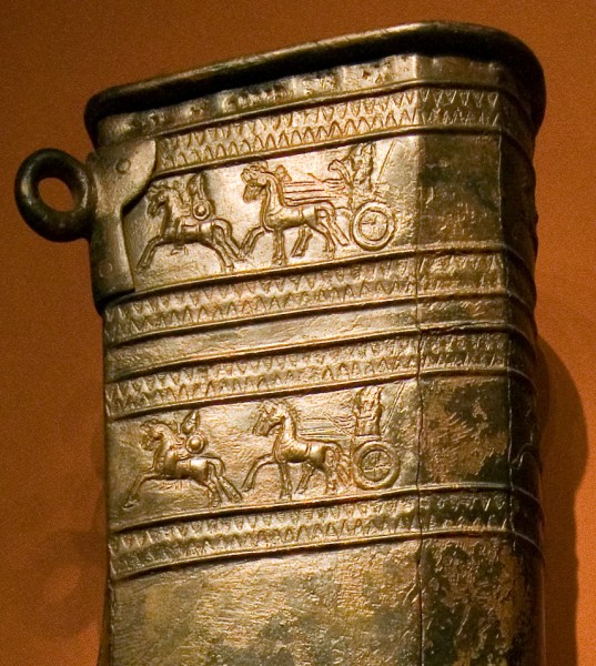
Urartu Decorated Quiver
By the 7th century BCE, Urartu controlled a territory which stretched from the Caspian Sea to the Upper Euphrates (east to west) and the Caucasus mountains in the north to the Taurus Range in the south. The chief adversary of Urartu was the Neo-Assyrian Empire, although there is also evidence of trade relations between the two states. The Assyrian ruler Tiglath-Pileser III (r. 745-727 BCE) was especially aggressive, and he laid siege to Tushpa. Another significant conflict between the two states was during the campaign of Sargon II (722-705 BCE) in 714 BCE.
Decline
The Urartu kingdom came to a violent end when sometime between c. 640 and c. 590 BCE its cities were destroyed. Weakened by decades of battles with the Assyrians, it may have been too overstretched to control its own empire. The perpetrators are not known, but the Scythians are one candidate, the Cimmerians another, and even possibly forces from within the territories administered by the Urartu kings. The kingdom was taken over by the Medes from c. 585 BCE onwards and then incorporated into the Achaemenian Empire of Cyrus the Great in the mid-6th century BCE.
THE FIRST KNOWN MENTION OF THE PERSIAN CLIENT STATE OF ARMENA OR ARMENIA IS RECORDED IN A C. 520 BCE INSCRIPTION OF DARIUS I.
ORONTID DYNASTY (C. 570 - C. 200 BCE)
Persian Satraps
The Orontid dynasty succeeded the Kingdom of Urartu in ancient Armenia and ruled from the 6th to 3rd century BCE. The founder of the royal dynasty of the Orontids was Orontes (Yervand) Sakavakyats (c. 570-560 BCE, although reign dates for most of the Orontids are disputed). Initially, the Orontids ruled as Persian satraps as the Achaemenians divided their new territory into two parts, and it was in the eastern province that the Orontid dynasty, known locally as the Yervand (from the Iranian word arvand, meaning “mighty”), ruled as satraps on behalf of their Persian overlords. Thus, Persian culture, language and political practices were introduced into ancient Armenia which still maintained its own Urartian traditions, too.
A primeira menção conhecida do estado do cliente Persa de Armena ou Armênia é registrada em um c. 520 AEC inscrição de Dario I (r. 522-486 AEC) numa face de pedra em Behistun, na Pérsia, que lista as posses reais do rei em persa antigo. A antiga capital urartiana de Van foi também a primeira capital dos orontídeos. Uma tentativa de se separar do Império Persa em 522 aC teve vida curta, sendo a Armênia uma fonte de soldados e tributos muito valiosa, especialmente cavalos. A vida sob o domínio persa parece ter sido pelo menos tolerável e a cultura armênia deixou de seguir seu próprio caminho. Em meados do século IV aC, as duas regiões divididas sob o controle persa haviam sido fundidas politicamente, suas populações haviam se misturado e a língua se tornara uma só: armênia.
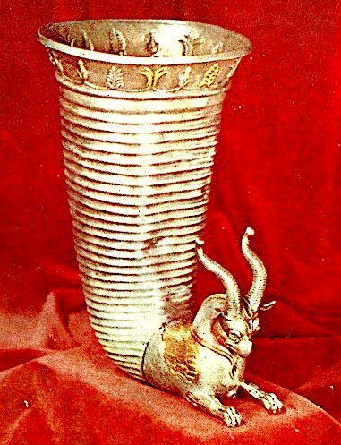
Orótida de Prata Rhyton
Império Macedônio
Após a ascensão de Alexandre, o Grande, a Armênia foi formalmente anexada pela Macedônia, e em 330 aC, Armavir foi transformada em capital (a antiga cidade urartiana de Argishtihinili). Parece provável que o governo político da Armênia permanecesse como sob os persas, embora os Oronides governassem como reis semi-independentes dentro do vasto Império Macedônio. De fato, mesmo os governantes armênios lutavam para controlar os poderosos senhores locais, conhecidos como nakharars e formar uma nobreza hereditária, tal era a natureza “feudal” da região naquela época.
A ARMÉNIA GOVERNADA POR SELECUIDOS, QUE LEVA A UM CERTO HELLENIZAÇÃO, QUE CRIARU UMA MISTURA CULTURAL RICA DE ELEMENTOS ARMÊNIOS, PERSAS E GREGOS.
Império Seleucida
A partir de 321 aC, os selêucidas governaram a porção asiática do império de Alexandre após a morte do jovem líder, levando a uma certa helenização, que criou uma rica mistura cultural de elementos armênios, persas e gregos. Tal era o tamanho do Império Selêucida que os governantes Orontid eram, novamente, largamente deixados para desfrutar de uma boa dose de autonomia naquela que era agora uma região com três áreas distintas: Menor Armênia (a noroeste, perto do Mar Negro), Maior Armênia (o coração tradicional do povo armênio) e Sophene (aka Dsopk, no sudoeste). A independência dos reis orodídeos é ilustrada pela cunhagem de sua própria moeda.
Antiochus III e Declínio
Por volta de 260 aC, o reino recém-unificado de Commagene e Sophene surgiu no oeste da Armênia, governado por Sames (também conhecido como Samos ), um regente da descendência dos Orontídeos. Foi Sames (rc 260-240 aC) quem fundou a importante cidade de Samosata (Shamshat). O período também viu o ressurgimento dos persas e o crescimento do Império Parta (247 aC - 224 EC), que agora reivindicava soberania sobre a Armênia. No entanto, o rei selêucida Antíoco III (r. 222-187 aC) reafirmou o controle sobre a Armênia e extraiu notavelmente 300 talentos de prata e 1.000 cavalos para seus exércitos enquanto eles atravessavam a região a caminho de reprimir os partos.
O último da dinastia Orontid a governar no leste da Armênia foi o Rei Orontes IV (também conhecido como Yervand o Último, rc 212-200 aC). Yervand mudou a capital de Armavir para o recém-fundado Yervandashat. Seu sucessor, após o assassinato do rei, foi o fundador da próxima dinastia a dominar a Armênia nos próximos séculos, o rei Artaxias I (Artashes) que foi apoiado e fez um sáplapa direto de Antiochus III, provavelmente em um movimento para reduzir a tendência de Independência armênia nas últimas décadas.
DINASTIA ARTAXIADA (C. 200 aC - 12 EC)
Artaxias I
Antíoco III não apenas mudou a casa governante da Armênia, ele criou dois sátrapas: Artaxias I (rc 200 - c. 160 aC) na Armênia e Zariadris no menor reino de Sophene a sudoeste. Quando Antíoco foi derrotado pelos romanos na Batalha de Magnésia em 190 aC, Artaxias declarou-se rei e começou a expandir seu reino, que ele consolidou através de uma centralização administrativa e inovações como estelas de fronteira para proclamar os direitos de propriedade e a autoridade da coroa.. Uma nova capital foi fundada em Artaxata (Artashat) em 176 aC. Aníbal, o grande general cartaginês, teria projetado as fortificações da cidade quando serviu Artaxias após sua derrota para os romanos.
Quando Artaxias eu morri, ele foi sucedido por seus filhos e a dinastia Artaxiad (também conhecida como dinastia Artashesiana) foi estabelecida. A Armênia, então, desfrutou de um período sustentado de prosperidade e importância regional, mas também seria perpetuamente espremida entre as duas superpotências da região: a Pártia e Roma. Ambos se revezariam em apresentar seu próprio candidato para governar a Armênia, que se tornou uma zona intermediária entre os dois impérios.

Império de Tigranes o Grande
Tigranes, o Grande
Um dos maiores reis de Artaxiad, ou mesmo qualquer rei armênio, era Tigranes II (Tigran II) ou Tigranes, o Grande (rc 95 - c. 56 aC). Ele expandiu o reino armênio consideravelmente; Primeiro, ele anexou o reino de Sophene em 94 aC. Então, com formidáveis máquinas de cerco e unidades de cavalaria fortemente blindada, ele conquistou a Capadócia, Adiabene, Gordyene, Fenícia e partes da Síria, incluindo Antioquia. O rei armênio até mesmo demitiu Ecbatana, a residência de verão real parta, em 87 aC, enquanto os partos lutavam para lidar com os nômades do norte invasores. No seu auge, o Império Armênio de Tigranes, o Grande, se estendia do Mar Negro até o Mediterrâneo. Not before or since would Armenians control such a huge swathe of Asia.
Tigranes called himself the "king of kings" from 85 BCE, and he founded a new capital city in 83 BCE, Tigranocerta (aka Tigranakert, and of uncertain location) which was famously Hellenistic in its architecture. The Greek language was likely used, along with Persian and Aramaic, as the language of the nobility and administration while commoners spoke Armenian. Persian elements continued to be an important part of the Armenian cultural mix, too, especially in the area of religion.
FOLLOWING A ROMAN ATTACK C. 66 BCE LED BY POMPEY THE GREAT, ARMENIA WAS MADE INTO A ROMAN PROTECTORATE.
Roman-Parthian Wars & Decline
Tigranes allied himself with Mithridates VI, the king of Pontus (r. 120-63 BCE) whose daughter he married. The Roman Republic, seeing the danger of such an alliance between the two regional powers, responded by attacking Pontus, and when Mithridates fled to the court of Tigranes in 70 BCE, the Romans invaded Armenia. Tigranocerta was captured in 69 BCE, and the Armenian king was forced to abandon his conquests. Following another Roman attack c. 66 BCE, this time led by Pompeythe Great, Armenia was made into a Roman protectorate. The Artaxiads continued to rule but were obliged to involve themselves in the Roman-Parthian wars, providing troops for both Marcus Licinius Crassus in 53 BCE and Mark Antony in 36 BCE. The latter general, dissatisfied with Armenian support, attacked the kingdom in 34 BCE and took the king, Artavasdes II (rc 56-34 BCE), to Alexandria where he would later be executed by Queen Cleopatra. A game of musical thrones then followed with first a Roman-backed king in Armenia, and then a Parthian-backed candidate until a new family took over the throne in 12 CE, the Arsacid (Arshakuni) dynasty.
ARSACID DYNASTY (12 CE - 428 CE)
Tiridates I
The founder of the Arsacid dynasty was Vonon (Vonones), but as he was succeeded by several short-ruling kings, some historians consider the founder proper of the dynasty to be Tiridates I of Armenia (r. 63 - 75 or 88 CE). He was the brother of the Parthian king Vologases I (rc 51-78 CE) who invaded Armenia in 52 CE for the specific purpose of setting Tiridates on the throne. The Romans were not content to let Parthia into their buffer zone, and in 54 CE, Emperor Nero (r. 54-68 CE) sent an army under his best general Gnaeus Domitius Corbulo. A decade of intermittent warfare, which saw such important Armenian cites as Artaxata and Tigranocerta captured, ended in the 63 CE Treaty of Rhandia. It was now agreed that Parthia had the right to nominate Armenian kings but Rome the right to crown them. Nero was thus given the privilege of crowning Tiridates in Rome in a lavish spectacle.
Ruins of Roman Baths at Garni Temple
Roman Interventions
Vespasian (r. 69-79 CE) made sure that no more territories would fall to the Parthian ruling dynasty by annexing the neighbouring kingdoms of Commagene and Lesser Armenia in 72 CE. A period of peace then followed until Emperor Trajan (r. 98-117 CE), using the excuse of not being consulted on a change in monarch, grabbed the moment and annexed Armenia for Rome. He then declared war on Parthia in 114 CE. Ultimately, Armenia was made a province of the Roman Empire and administered alongside Cappadocia.
Emperor Hadrian (r. 117-138 CE) was much less enthusiastic about keeping the bothersome province, and he allowed it to become independent. Various Parthian and Roman incursions occurred over the next century but Artaxata, at least, prospered after it was made one of the official trading points between the two empires.
Sasanian Empire
Following the rise of the Sasanid dynasty from 224 CE, there was a more aggressive Persian foreign policy towards Armenia which culminated in a full-scale invasion by the Sasanids in 252 CE. The Armenian Arsacid kings, with such close blood ties to the vanquished Arsacids in Persia, posed a threat of legitimacy to the new Sasanid order. The Sasanids won several major victories against Rome in this period, but the Romans were resurgent in the 4th century CE. When the dust finally settled again the kingdom of Armenia found itself divided up between Rome and Persia, with the Arsacids continuing to rule only western Armenia. In 298 CE, under the auspices of Diocletian (r. 284-305 CE), Armenia was unified with Tiridates IV (Trdat III or IV) as king (rc 298 - c. 330 CE) - one of the great rulers of the Arsacid dynasty.

Arsacid Armenia
Tiridates the Great & Christianity
Tiridates the Great set about centralising his kingdom and reorganising the provinces and their governors. Land surveys were also carried out to better identify tax obligations; the king was determined to make Armenia great once again. By far the most lasting event of this period was Armenian's official adoption of Christianity c. 314 CE, if not earlier. Tradition records that Tiridates himself was converted in 301 CE by Saint Gregory the Illuminator. One consequence of the move was that the persecution of the religion by Persia helped to create a more fiercely independent state. Saint Gregory, then known as Grigor Lusavorich, was made the first bishop of Armenia in 314 CE. Tiridates IV may also have adopted Christianity for internal political reasons - the end of the pagan religion was a fine excuse to confiscate the old temple treasuries and a monotheistic religion with the monarch as God's representative on earth might well instil greater loyalties from his nobles, the nakharars, and people in general.
THEODOSIUS I & SHAPUR III AGREED TO FORMALLY DIVIDE ARMENIA BETWEEN THE EASTERN ROMAN (BYZANTINE) EMPIRE & SASANID PERSIA.
Division & Decline
There was a greater threat from outside Armenia though, as the Sasanids again became more ambitious to rule directly over Armenia and made attacks on Armenian cities. It was then that emperor Theodosius I (r. 379-395 CE) and Shapur III (r. 383-388 CE) agreed to formally divide Armenia between the Eastern Roman (Byzantine) Empire and Sasanid Persia.
In 405 CE the Armenian alphabet was invented by Mesrop Mashtots and the Bible translated into that language, helping to further spread and entrench Christianity in Armenia. Politically, though, it was time for a change. The last Arsacid ruler was Artashes IV (r. 422-428 CE) after the Armenian crown, unable to repress the pro-Persian and anti-Christian factions at court, was abolished by Persia and viceroy rulers, the marzpans, were installed.
MAMIKONIAN DYNASTY (428-652 CE)
The Mamikonains
The last great dynasty to rule ancient Armenia was the Mamikonians who had been a powerful force in the Armenian military ever since the 1st century BCE. By the end of the 4th century CE the hereditary office of grand marshal ( sparapet ), who led the armed forces of Armenia, usually had a Mamikonian lord in the position. Amongst the other noble families the Mamikonians had been only second in importance to the Arsacid royal family itself, indeed two members had even served as regents: Mushegh and Manuel Mamikonian. Once the ruling house of Arsacid fell, the Mamikonians were left to dominate state affairs within the limitations imposed by their Persian overlords.
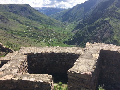
Armenia's Smbataberd Fortress
Persia & Avarayr
Persia installed marzpan rulers in their half of the country (Persarmenia) from 428 CE. Representing the Sasanian king, the marzpans had full civilian and military authority. There had been rumblings of discontent amongst the Armenian nobility and clergy following Persian cultural imperialism, but matters really came to a head with the succession of the Persian king Yazdgird (Yazdagerd) II in c. 439 CE. Sasanid rulers had long been suspicious that Armenian Christians were all simply spies of Byzantium, but Yazdgird was a zealous proponent of Zoroastrianism and the double-edged sword of political and religious policy was about to cut Armenia down to size.
In May or June 451 CE at the Battle of Avarayr (Avarair) in modern Iran, the Armenians rebelled against oppression and faced a massive Persian army. The 6,000 or so Armenians were led by Vardan Mamikonian, but unfortunately for them, help from the Christian Byzantine Empire was not forthcoming despite an embassy sent for that purpose. Perhaps not unexpectedly, the Persian-backed marzpan, Vasak Siuni, was nowhere to be seen in the battle either. The Persians, greatly outnumbering their opponents and fielding an elite corps of “Immortals” and a host of war elephants, won the battle easily enough and massacred their opponents; 'martyred' would be the term used by the Armenian Church, thereafter. Indeed, the battle became a symbol of resistance with Vardan, who died on the battlefield, even being made a saint.
Minor rebellions continued over the next few decades, and the Mamikonians continued a policy of careful resistance. The strategy paid off, for in 484 CE the Treaty of Nvarsak was signed between the two states, which granted Armenia a greater political autonomy and freedom of religious thought. In a full turnaround, Vahan, the nephew of Vardan, was made the marzpan in 485 CE. Peace brought prosperity and trade flourished as Artashat became an important trading point between the Byzantine and Persian Empires. Armenia was finding its feet as a unified nation, helped by language, the Christian faith, and such figures as Movses Khorenatsi ( Moses of Khoren) who wrote his History of the Armenians, the first comprehensive history of the country in the late 5th century CE.
The Umayyad Caliphate
Armenia's geographical position would, yet again, cause its downfall. By the end of the 6th century CE, Persia and the Byzantine Empire created yet another division which saw Byzantium acquire two-thirds of Armenia. Worse was soon to come, though, following the dramatic rise of a new power in the region, the Arab Umayyad Caliphate, which conquered the Sasanid capital Ctesiphon in 637 CE and Armenia between 640 to 650 CE. The country was formally annexed as an Umayyad province in 701 CE.
This article was made possible with generous support from the National Association for Armenian Studies and Researchand the Knights of Vartan Fund for Armenian Studies.
LICENSE
Article based on information obtained from these sources:with permission from the Website Ancient History Encyclopedia
Content is available under License Creative Commons: Attribution-NonCommercial-ShareAlike 3.0 Unported. CC-BY-NC-SA License