Indo-European Languages › Taxila » Ancient origins
Articles and Definitions › Contents
- Indo-European Languages › Antique Origins
- Taxila › Ancient History
Ancient civilizations › Historical and archaeological sites
Indo-European Languages › Antique Origins
Definition and Origins

The Indo-European languages are a family of related languages that today are widely spoken in the Americas, Europe, and also Western and Southern Asia. Just as languages such as Spanish, French, Portuguese and Italian are all descended from Latin, Indo-European languages are believed to derive from a hypothetical language known as Proto-Indo-European, which is no longer spoken.
It is highly probable that the earliest speakers of this language originally lived around Ukraine and neighbouring regions in the Caucasus and Southern Russia, then spread to most of the rest of Europe and later down into India. The earliest possible end of Proto-Indo-European linguistic unity is believed to be around 3400 BCE.
Since the speakers of the Proto-Indo-European language did not develop a writing system, we have no physical evidence of it. The science of linguistics has been trying to reconstruct the Proto-Indo-European language using several methods and, although an accurate reconstruction of it seems impossible, we have today a general picture of what Proto-Indo-European speakers had in common, both linguistically and culturally. In addition to the use of comparative methods, there are studies based on the comparison of myths, laws, and social institutions.
BRANCHES OF INDO-EUROPEAN LANGUAGES
The Indo-European languages have a large number of branches: Anatolian, Indo-Iranian, Greek, Italic, Celtic, Germanic, Armenian, Tocharian, Balto-Slavic and Albanian.
Anatolian
This branch of languages was predominant in the Asian portion of Turkey and some areas in northern Syria. The most famous of these languages is Hittite. In 1906 CE, a large amount of Hittite finds were made on the site of Hattusas, the capital of the Hittite Kingdom, where about 10,000 cuneiform tablets and various other fragments were found in the remains of a royal archive. These texts date back to the mid to late second millennium BCE. Luvian, Palaic, Lycian, and Lydian are other examples of families belonging to this group.
All languages of this branch are currently extinct. This branch has the oldest surviving evidence of an Indo-European language, dated about 1800 BCE.
Indo-Iranian
This branch includes two sub-branches: Indic and Iranian. Today these languages are predominant in India, Pakistan, Iran, and its vicinity and also in areas from the Black Sea to western China.
Sanskrit, which belongs to the Indic sub-branch, is the best known among the early languages of this branch; its oldest variety, Vedic Sanskrit, is preserved in the Vedas, a collection of hymns and other religious texts of ancient India. Indic speakers entered into the Indian subcontinent, coming from central Asia around 1500 BCE: In the Rig- Veda, the hymn 1.131 speaks about a legendary journey that may be considered a distant memory of this migration.
Avestan is a language that forms part of the Iranian group. Old Avestan (sometimes called Gathic Avestan) is the oldest preserved language of the Iranian sub-branch, the “sister” of Sanskrit, which is the language used in the early Zoroastrian religious texts. Another important language of the Iranian sub-branch is Old Persian, which is the language found in the royal inscriptions of the Achaemenid dynasty, starting in the late 6th century BCE. The earliest datable evidence of this branch dates back to about 1300 BCE.
Today, many Indic languages are spoken in India and Pakistan, such as Hindi-Urdu, Punjabi, and Bengali. Iranian languages such as Farsi (modern Persian), Pashto, and Kurdish are spoken in Iraq, Iran, Afghanistan, and Tajikistan.
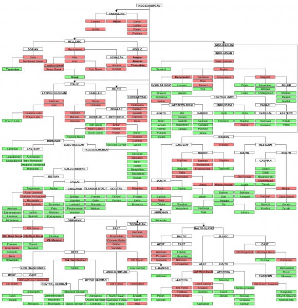
Indo-European language family tree
Greek
Rather than a branch of languages, Greek is a group of dialects: During more than 3000 years of written history, Greek dialects never evolved into mutually incomprehensible languages. Greek was predominant in the southern end of the Balkans, the Peloponnese peninsula, and the Aegean Sea and its vicinity. The earliest surviving written evidence of a Greek language is Mycenaean, the dialect of the Mycenaean civilization, mainly found on clay tablets and ceramic vessels on the isle of Crete. Mycenaean did not have an alphabetic written system, rather it had a syllabic script known as the Linear B script.
The first alphabetic inscriptions have been dated back to the early 8th century BCE, which is probably the time when the Homeric epics, the Iliad and the Odyssey, reached their present form. There were many Greek dialects in ancient times, but because of Athens cultural supremacy in the 5th century BCE, it was the Athens dialect, called Attic, the one that became the standard literary language during the Classical period (480-323 BCE). Therefore, the most famous Greek poetry and prose written in Classical times were written in Attic: Aristophanes, Aristotle, Euripides, and Plato are just a few examples of authors who wrote in Attic.
Italic
This branch was predominant in the Italian peninsula. The Italic people were not natives of Italy ; they entered Italy crossing the Alps around 1000 BCE and gradually moved southward. Latin, the most famous language in this group, was originally a relatively small local language spoken by pastoral tribes living in small agricultural settlements in the centre of the Italian peninsula. The first inscriptions in Latin appeared in the 7th century BCE and by the 6th century BCE it had spread significantly.
Rome was responsible for the growth of Latin in ancient times. Classical Latin is the form of Latin used by the most famous works of Roman authors like Ovid, Cicero, Seneca, Pliny, and Marcus Aurelius. Other languages of this branch are: Faliscan, Sabellic, Umbrian, South Picene, and Oscan, all of them extinct.
Today Romance languages are the only surviving descendants of the Italic branch.
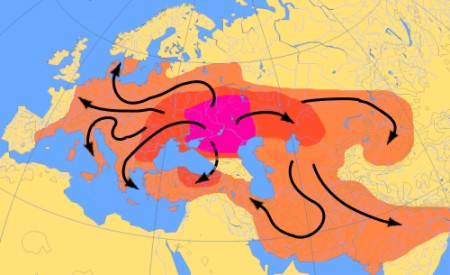
Map of Indo-Euopean Migrations
Celtic
This branch contains two sub-branches: Continental Celtic and Insular Celtic. By about 600 BCE, Celtic-speaking tribes had spread from what today are southern Germany, Austria, and Western Czech Republic in almost all directions, to France, Belgium, Spain, and the British Isles, then by 400 BCE, they also moved southward into northern Italy and southeast into the Balkans and even beyond. During the early 1st century BCE, Celtic-speaking tribes dominated a very significant portion of Europe. On 50 BCE, Julius Caesar conquered Gaul (ancient France) and Britain was also conquered about a century later by the emperor Claudius. As a result, this large Celtic-speaking area was absorbed by Rome, Latin became the dominant language, and the Continental Celtic languages eventually died out. The chief Continental language was Gaulish.
Insular Celtic developed in the British Isles after Celtic-speaking tribes entered around the 6th century BCE. In Ireland, Insular Celtic flourished, aided by the geographical isolation which kept Ireland relatively safe from the Roman and Anglo- Saxoninvasion.
The only Celtic languages still spoken today (Irish Gaelic, Scottish Gaelic, Welsh and Breton) all come from Insular Celtic.
Germanic
The Germanic branch is divided in three sub-branches: East Germanic, currently extinct; North Germanic, containing Old Norse, the ancestor of all modern Scandinavian languages; and West Germanic, containing Old English, Old Saxon, and Old High German.
The earliest evidence of Germanic-speaking people dates back to first half of the 1st millennium BCE, and they lived in an area stretching from southern Scandinavia to the coast of the North Baltic Sea. During prehistoric times, the Germanic speaking tribes came into contact with Finnic speakers in the north and also with Balto-Slavic tribes in the east. As a result of this interaction, the Germanic language borrowed several terms from Finnish and Balto-Slavic.
Several varieties of Old Norse were spoken by most Vikings. Native Nordic pre-Christian Germanic mythology and folklore has been also preserved in Old Norse, in a dialect named Old Icelandic.
Dutch, English, Frisian, and Yiddish are some examples of modern survivors of the West Germanic sub-branch, while Danish, Faroese, Icelandic, Norwegian, and Swedish are survivors of the North Germanic branch.
Armenian
The origins of the Armenian-speaking people is a topic still unresolved. It is probable that the Armenians and the Phrygians belonged to the same migratory wave that entered Anatolia, coming from the Balkans around the late 2nd millennium BCE.The Armenians settled in an area around Lake Van, currently Turkey; this region belonged to the state of Urartu during the early 1st millennium BCE. In the 8th century BCE, Urartu came under Assyrian control and in the 7th century BCE, the Armenians took over the region. The Medes absorbed the region soon after and Armenia became a vassal state. During the time of the Achaemenid Empire, the region turned into a Persian satrap. The Persian domination had a strong linguistic impact on Armenian, which mislead many scholars in the past to believe that Armenian actually belonged to the Iranian group.
Tocharian
The history of the Tocharian-speaking people is still surrounded by mystery. We know that they lived in the Taklamakan Desert, located in western China. Most of the Tocharian texts left are translations from well-known Buddhist works, and all of these texts have been dated between the 6th and the 8th centuries CE. None of these texts speak about the Tocharians themselves.Two different languages belong to this branch: Tocharian A and Tocharian B. Remains of the Tocharian A language have only been found in places where Tocharian B documents have also been found, which would suggest that Tocharian A was already extinct, kept alive only as a religious or poetic language, while Tocharian B was the living language used for administrative purposes.
Many well-preserved mummies with Caucasoid features such as tall stature, red, blonde, and brown hair, have been discovered in the Taklamakan Desert, dating between 1800 BCE to 200 CE. The weaving style and patterns of their clothes is similar to the Hallstatt culture in central Europe. Physical analysis and genetic evidence have revealed resemblances with the inhabitants of western Eurasia.
This branch is completely extinct. Among all ancient Indo-European languages, Tocharian was spoken farthest to the east.
Balto-Slavic
This branch contains two sub-branches: Baltic and Slavic.
During the late Bronze Age, the Balts' territory may have stretched from around western Poland all the way across to the Ural Mountains. Afterwards, the Balts occupied a small region along the Baltic Sea. Those in the northern part of the territory occupied by the Balts were in close contact with Finnic tribes, whose language was not part of the Indo-European language family: Finnic speakers borrowed a considerable amount of Baltic words, which suggests that the Balts had an important cultural prestige in that area. Under the pressure of Gothic and Slavic migrations, the territory of the Balts was reduced towards the 5th century CE.
Archaeological evidence shows that from 1500 BCE, either the Slavs or their ancestors occupied an area stretching from near the western Polish borders towards the Dnieper River in Belarus. During the 6th century CE, the Slav-speaking tribes expanded their territory, migrating into Greece and the Balkans: this is when they are mentioned for the first time, in Byzantine records referring to this large migration. Either some or all of the Slavs were once located further to the east, in or around Iranian territory, since many Iranian words were borrowed into pre-Slavic at an early stage. Later on, as they moved westward, they came into contact with German tribes and again borrowed several additional terms.
Only two Baltic languages survive today: Latvian and Lithuanian. A large number of Slavic languages survive today, such as Bulgarian, Czech, Croatian, Polish, Serbian, Slovak, Russian, and many others.
Albanian
Albanian is the last branch of Indo-European languages to appear in written form. There are two hypotheses on the origin of Albanian. The first one says that Albanian is a modern descendant of Illyrian, a language which was widely spoken in the region during classical times. Since we know very little about Illyrian, this assertion can be neither denied nor confirmed from a linguistic standpoint. From a historical and geographical perspective, however, this assertion makes sense. Another hypotheses says that Albanian is a descendant of Thracian, another lost language that was spoken farther east than Illyrian.
Today Albanian is spoken in Albania as the official language, in several other areas in of the former Yugoslavia and also in small enclaves in southern Italy, Greece and the Republic of Macedonia.
Unaffiliated Languages
All languages in this group are either extinct or they are a former stage of a modern language. Examples of this groups of languages are Phrygian, Thracian, Ancient Macedonian (not to be confused with Macedonian, a language currently spoken in the Republic of Macedonia, part of the Slavic branch), Illyrian, Venetic, Messapic, and Lusitanian.
INDO-EUROPEAN HISTORICAL LINGUISTICS
In ancient times it was noticed that some languages presented striking similarities: Greek and Latin are a well-known example.During classical antiquity it was noted, for example, that Greek héks “six” and heptá “seven” were similar to the Latin sex and septem. Furthermore, the regular correspondence of the initial h- in Greek to the initial s- in Latin was pointed out.
The explanation that the ancients came up with was that the Latin language was a descendant of Greek language. Centuries later, during and after the Renaissance, the close similarities between more languages were also noted, and it was understood that certain groups of languages were related, such as Icelandic and English, and also the Romance languages. Despite all of these observations, the science of linguistics did not develop much further until the 18th century CE.
During the British colonial expansion into India, a British orientalist and jurist named Sir William Jones became familiar with the Sanskrit language. Jones was also knowledgeable in Greek and Latin and was surprised by the similarities between these three languages. During a lecture on February 2, 1786 CE, Sir William Jones expressed his new ideas:
The Sanskrit language, whatever be its antiquity, is of a wonderful structure; more perfect than the Greek, more copious than the Latin, and more exquisitely refined than either, yet bearing to both of them a stronger affinity, both in the roots of verbs and the forms of grammar, than could possibly have been produced by accident; so strong indeed, that no philologer could examine them all three, without believing them to have sprung from some common source, which, perhaps, no longer exists; there is a similar reason, though not quite so forcible, for supposing that both the Gothic and the Celtic, though blended with a very different idiom, had the same origin with the Sanskrit; and the old Persian might be added to the same family, if this were the place for discussing any question concerning the antiquity of Persia. (Fortson, p. 9)
The idea that Greek, Latin, Sanskrit, and Persian were derived from a common source was revolutionary at that time. This was a turning point in the history of linguistics. Rather than the “daughter” of Greek, Latin was for the first time understood as the “sister” of Greek. By becoming familiar with Sanskrit, a language geographically far removed from Greek and Latin, and realizing that chance was an insufficient explanation for the similarities between these languages, Sir William Jones presented a new insight which triggered the development of modern linguistics.
Taxila › Ancient History
Definition and Origins
When it comes to ancient history, Pakistan contains its fair share of treasures, one of the prominent of these being the ancient metropolis of Taxila. It is a city of the Gandharan civilization, sometimes known as one of its capitals, whose history can be traced from early microlithic communities at the Khanpur caves up to almost 1000 CE. Taxila was a hub of Buddhism, a centre of learning, an urban metropolis and a meeting point of various cultures, namely the Achaemenids, Greeks, Mauryans, Scythians, Parthians, Kushans, Huns and eventually the Muslims.
Although it was lost to time for nearly 1000 years following its decline, the metropolis and its multitude of treasures came to light in the late 1800s CE under Alexander Cunningham who was an antiquarian for the British Raj and more prominently under John Marshall, the first director of the Archaeological Survey of India in the early 1900s CE, a time when archaeologyworldwide had became a much more disciplined field and new discoveries were coming to light from all over the world. Along with discovering the Indus Valley civilization, Marshall also did major work in Taxila which bring to light this ancient and mysterious culture.
LOCATION
The Taxila archaeological site is located in the province of Punjab, Pakistan, about 30 km north of the Capital Territory of Islamabad. It lies off the famous and historical Grand Trunk Road. The modern archaeological region of Taxila is composed of 18 sites of significant cultural value which were inducted as a whole into the UNESCO world heritage umbrella in 1980 CE.

Map of Gandhara
The region is of particular interest when one looks at its ancient role as being a waypoint for the movement of caravans and even today it still holds the same function as in the 6th century BCE. This continuing function of the site as a waypoint tells us about the urban pattern of ancient Taxila (being more or less unchanged since antiquity) and how that affects development and the spread of crafts, settlements and markets as well as an institutional framework which develops as a result of the need to manage the surrounding population.
Although the region fell out of favor with the increase in sea trade in later times, the preceding centuries of occupation meant that a massive amount of archaeological data still remains in the region which has been slowly and gradually unearthed from the British era down to the present day.
PRE-HISTORY OF TAXILA
The beginnings of human occupation in the area can be traced back to the microlithic hunters of the period before 3500 BCE, most importantly at three important caves discovered in 1964 CE by Elden Johnson of the University of Minnesota at Bhamala, Mohra Moradu and Khanpur. Particularly at the Khanpur cave, 2.9m (9 ft 7 inches) of cultural deposit was found dating from 900 CE all the way back to the stone age.
Early agricultural communities developed around 3500-2700 BCE as is evidenced from the small mound of Saraikala - "small" being relative as it is 305 m (1000 ft) east to west and 610 m (2000 ft) north to south - excavated by Ahmad Hasan Dani, a pioneering archaeologist of Pakistan. This site contains evidence of stone, bone and handmade pottery. The stone objects include microliths, axes and maceheads along with parallel-sided blades, side and end scrapers, and assymetrical flakes and arrowheads. Ground stone tools are also found such as chisels as well as saddle querns, grinders and pounders for daily use.Bone tools belonging to five categories have been found including awls, perforators, spatulas, points and pressure flakes.Pottery is the third industry with the earliest examples being almost all handmade and divided into four subcategories.
The Bronze Age begins in the region around 2700-2100 BCE and is also evidenced at Saraikala with no break between the end of the neolithic to the Bronze age deposits. There is even a transitional period between the two ages which includes mixed implements of neolithic and bronze age varieties.

Map of Taxila
TAKHSHASHILA
According to mythology Taxila is said to have been founded by the son of the brother of the legendary hero Rama, and stood on a hill that commanded the river Tamra Nala, a tributary of the Indus. It is held to have been an important cultural centre since inception, and the Mahabharata was reported to have first been recited here. The site of the first city at Taxila is known now as the Bhir Mound.
The city of Taxila, known in antiquity as Takhshasila, was a renowned site of Buddhist Gandhara, especially after Ashoka's rule and in the 1st century CE Kushan era. The name Taxila is a Greek approximation of the original name. In Aramaic the city is known as Naggaruda, the 'City of Cut Stones' which is also the Buddhist name for the city, at least if taken literally ie taksmeanining to cut or fashion something, which implies this name. However, in the same vein sila is also related to "sira" meaning "head" in Buddhist traditions and relates to the story of the Boddhisattva who voluntary had himself beheaded in sacrifice to a local Brahman in the city of Bhadrasila which the Buddha, while relating this story, is said to have linked to Taxila. The city of Sirkap also has a similar meaning ie sir or head and kap, to cut but this has not been proven satisfactorily yet.
Chu-cha-shi-lo is the Chinese name given to the region found in the accounts of the Chinese pilgrims. In Sanskrit, it is known as Takshasila, Takkasila or Takhashila and was also said to be the land of the Takhshas-a serpent race who could change their form at will to mingle with humans. Another Brahmanical tradition relates that it was the capital city of Taksha, son of Bharata, who was installed here as king.
The ancient city was revered as having one of the world's first universities and flourished during the 1st to 5th centuries CE as part of the civilization of Gandhara under various rulers. A variety of subjects were taught there, including mathematics, sciences, philosophy, astronomy, medicine, politics, literature and military sciences although it was not an institutionalised center of learning but rather a combination of religious plus secular studies centered around monasteries.
Situated on "The Royal Highway" (as termed by the Greek Megasthenes) It was connected to Pataliputra (modern day Patna) in the north eastern reaches of the Mauryan Empire, western Asia (through Bactria ), across the Indus River at Hund and through Kashmir with Central Asia by way of Srinagar, leading down to Haripur. This allowed a steady influx of people from all over the Asiatic regions into the area in the form of traders, settlers, merchants, preachers and invaders.
POLITICAL CONTROL
Taxila and the region of Gandhara witnessed the rule of several major powers of antiquity as listed here:
- Achaemenids (~600-400 BCE)
- Greeks (~326-324 BCE),
- Mauryans (~324-185 BCE),
- Indo-Greeks (~250-190 BCE),
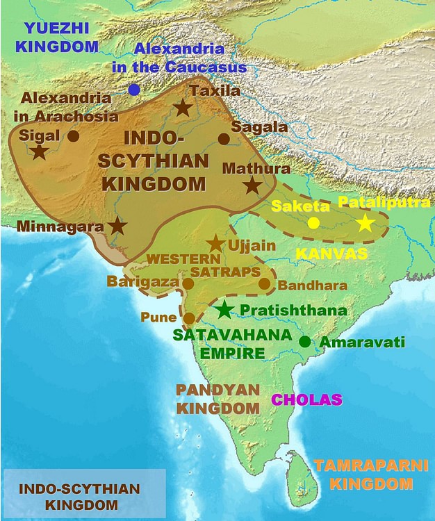
- Scythians (~2nd century to 1st century BCE),
- Parthians (~1st century BC to 1st century CE),
- Kushans (~1st to 5th century CE),
- White Huns (~5th century CE)
- Hindu Shahi (~9th to 10th century CE).
This was followed by Muslim conquests by which time we come to the medieval period of Indian history.
The Achaemenian rule in Gandhara lasted from the 6th Cent BCE to 327 BCE, when Alexander of Macedon invaded the region. However he wasn't able to hold it for too long and his armies turned back towards their homes soon after and following this void, Chandragupta Maurya reconquered the region and began the Mauryan dynasty in c.321 BCE, the first unifying dynasty of India. This dynasty collapsed after the demise of its greatest ruler, Asoka (c.273-232 BCE).
The region hence fell into another vaccum which was filled by the so called Indo or Bactrian Greeks in 190 BCE, who were part of garrisons left behind by the conquering hellenes and had established themselves in the region of Bactria in modern day northern Afghanistan. They ruled for approximately a century and were followed swiftly by the Scythians (or Sakas) from Central Asia, who were in turn followed by the Parthians in the middle of the 1st Cent BCE.
Following another approximate century of rule by the Parthians, there was another invasion in 50 CE by the Kushans, who were a branch of the North Western Chinese Yue-Chi tribes and they conquered the Kabul Valley and Gandhara. Their heyday was in the time of Kanishka (c. 78 CE) who was their most renowned emperor and the Kushan empire (of which Gandhara was an important center) stretched from Merve in the west to Khotan in the east with the Aral sea bounding the north and the Arabian sea at the south. Two other prominent successors of Kanishka were Huvishka and Vasudeva.
The tail end of the Kushan rule saw a succession of short lived dynasties taking over control of the Gandhara region, and this resulted in a situation where the region was constantly being raided, invaded or in some way or the other in turmoil. Quick succession of rule by the Sassanids, Kidarites (or little Kushans) and finally the White Huns following the ebbing of Kushan rule led to the day to day religious, trade and social activity coming to a standstill.
Dharmarajika Stupa (Taxila)
ARCHITECTURAL HIGHLIGHTS
The stupas came to represent the zenith of buddhist architectural achievement in the region and of course, as with the artwork, they are also meant solely to promote the religious power structures. The stupas themselves were decorated with uncountable relief panels and friezes depicting religious stories and events further solidifying their role.
Some of the most prominent stupas include:
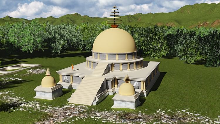
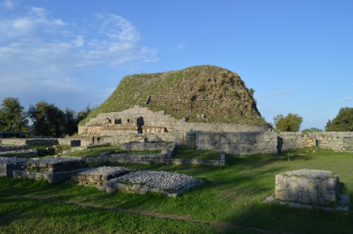
Dharmarajika Stupa
This is the largest Buddhist establishment in the Taxila region and dates from the time of Ashoka, the great Mauryan emperor who united India in the 3rd cent BCE and is known in some Buddhist sources as Dharmaraj, the name which the site itself is associated with.
It is firmly believed by most scholars that Dharmarajika is one of the locations where the remains of the Buddha himself were buried and this makes it a relic depository stupa or Dhatu-Garbha stupa. Ashoka had an afinity to Taxila due to his governership of the area during the time of his father Bindusara and hence also chose this as one of the locations to re-inter the remains of the historical Buddha.
The current site is the second reconstruction over the original Ashokan stupa, the first one occuring in the post earthquake period in the Kushan era (1st Cent CE) and the other much later. The original stupa was presumably smaller and humbler over which the existing dome was established, with radiating support walls like wheel spokes holding up the dome itself. The dome is 45 feet in height inside a 150 ft square having a diameter of approximately 115ft on average, not including the processional path.
Kunala Stupa
The legend associated with this stupa connects it to Kunala, son of Ashoka. Kunala was then governor of Taxila and his step mother lusted for him. He rebutted her advances and in her rage she sent a fake missive by Ashoka to Taxila asking the administrators to blind Kunala. Kunala accepted the punishment even though he was guiltless, and afterwards led the life of a wandering mistrel, singing the story of his misfortune anonymously. He managed to make his way to Ashoka while wandering India, and Ashoka, upon hearing the song knew it to be his son and the story to be the truth and accepted him back, after which Kunala's sight was miraculously restored at Bodh Gaya.
The Stupa at Taxila was established to commemorate that legend although the existing remains cover an older stupa which has not been dated yet. The latest remains are dated to the 3rd-4th Cent CE.
Jaulian Stupa
This 2nd cent CE establishment is a highly decorated and compact construction which is situated in the neighborhood of the city of Sirsukh, rising 300 ft above the Taxila valley and within view of Sirsukh. The name Jaulian means "Seat of Saints" in the local language, a name which has probably existed since antiquity. The Jaulian establishment is a later work and is very lavish, harkening to a time in the Buddhist history of the region when the superficial depiction of the Buddha image was at its peak. It has numerous chapels and votive stupas in its two courts and once housed massive Buddha sculptures as well. Its location is considered one of the most picturesque in the region.
Other sites include the Mohra Moradu complex, Jinna Wali Dheri and the recently re-excavated Bhamala stupa (a rare cruciform stupa).

Mohra Moradu Stupa
Each of these establishments has associated monasteries and other auxiliary buildings creating a fairly uniform pattern of planning as with other Gandharan sites.
Although today Taxila is known as a "region", in antiquity it was the name of a city which spread over 3 sites dating from the vedic era down to the late ancient period. Known now by place names where the remains were found, the cities in antiquity were probably all known with the same name ie Takshasila. These include the archaeological remains today at:
Bhir Mound
The archaeological remains of this, the 1st city, exist south of the existing Taxila Museum covering an area of approximately 1200 x 730 yards rising 65 feet above the Tamra rivulet, the main ancient source of water for the city and consist of 4 levels ranging from the 5th-6th cent BCE ( Achaemenid period) to the 2nd cent BCE in the Indo/Bactrian Greek period.
Earlier excavations before the 1970s CE had revealed an organic layout without any evidence of fortifications. The masonry ranges from early rubble masonry in the earliest periods to more consistent masonry later on beginning in what is considered the Mauryan era (3rd-4th cent BCE). Thick coating of mud plaster is in evidence early on and later converts to lime plaster in the Indo-Greek period. Limestone and Kanjur stone are used for construction here.

Bhir Mound Excavations
The eastern excavations reveal dwelling houses and shops divided by streets and lanes. There is one mostly straight main street called First Street with other more meandering streets around it. The houses follow largely the same pattern of design and layout as rural houses of today do with a large open courtyard bound by rooms. The outer rooms faced the street and probably served as shops run by homeowners as evidenced by craft materials found from these rooms.
There is evidence of sophisticated drainage for both household water runoff as well as soak wells for sewage.
The most significant building is the Pillared Hall dating from 250-175 BCE, consisting of multiple spaces built over time.Terracotta reliefs and figurines depicting deities were found near this site leading to speculation that it would have been a religious shrine or temple, perhaps even one of the earliest Hindu shrines.
The most significant building is the Pillared Hall dating from 250-175 BCE, consisting of multiple spaces built over time.Terracotta reliefs and figurines depicting deities were found near this site leading to speculation that it would have been a religious shrine or temple, perhaps even one of the earliest Hindu shrines.
Excavations conducted from 1998-2000 CE by the Federal Archaeological Department of Pakistan unveiled regular town planning, wells and the city's encircling mud and wood rampart which had not been discovered before. These excavations were in the western portion of the site.
We can tell that Bhir predates Gandhara proper due to no Gandhara sculptures being found there yet and the topmost levels revealing only early Indo- Greek coinage with clear Hellenistic influences as well as early Indian punch-marked and bent bar coins. Other finds include beads, seals, terracotta figures and ritual objects all exhibited at Taxila Museum.

Sirkap Excavations, Taxila
Sirkap
The 2nd ancient city of Sirkap is thought to have been formally established by the Bactrian Greeks in the 2nd cent BCE. The name of the city is associated with a local legend of the hero Rasalu who fought the seven demon Rakhshasas. These were 7 sibling demons namely 3 brothers named Sirkap, Sirsukh and Amba, and 4 sisters named Kapi, Kalpi, Munda and Mandehi.Rasalu was the son of the Raja of Sakala (modern Sialkot) and on coming to the city he found that the demons were demanding sacrifices from the locals. He took it upon himself to kill the demons, vanquishing all but one which is said to still be in hiding. The city marks the spot where he killed the demon Sirkap.
The city has been attributed to the Greeks not only because of the archaeological remains but also because of various urban planning factors such as the flat ground, Hippodamian street pattern and geographical location with natural defences on all sides as well as the upper and lower cities (of which the lower is excavated) although these were also present in the earlier Indus cities. Nonetheless no buildings culturally related to the Greeks have been found such as temples, palaces or theatres which have cultural links to the Greek heritage. After the original planning was implemented, the subsequent settlement was quintissentially Indian.
The fortifications are massive with huge stone walls ranging 15ft to 21ft in thickness, with triple storey bastions at intervals.The fortifications run 6000 yards or 3 miles around the city and traverse the hills to the South as well.

City of Sirkap
7 occupation levels have been identified with the lowest one (7th) belonging to pre-Greek era and representing an outlying setlement of Bhir and the earliest one (1st) dating from the Scytho-Parthian era, a period of approximately 150 years (~90 BCE to ~60 CE) which saw conquests by the Scythians and then the Parthians in quick succession. Some areas of importance include the Royal Residence, Sun Temple, Apsidal Temple, Double Headed Eagle Stupa and the Jain Temple
Sirsukh
Founded in the 2nd half of the 1st cent CE, the Kushan city of Sirsukh was probably established either to shift the populace away from the earthquake ruined remains of Sirkap, or to establish a new capital to testify to the Kushan conquest.
It is a roughly rectangular city which is in the open plain with no natural defenses but with solidly built limestone fortifications having round towers at regular intervals, one of the first instances of round fortifications outside of the European continent.This was probably adopted by the Kushans during their interaction with Europe on their western borders.
Although an important part of the archaeological landscape, the site has not been properly excavated due to local farming in the area which would need to be heavily disrupted in order to facilitate the excavations. However the narrow strip of fortifications around the Lundi rivulet which hugs the walls on one side have revealed coin hoards of not just the Kushan rulers but also dating to the time of the Mughal emperor Akbar, showing that the city continued to function at least 1000 years after its original foundation.
DECLINE OF THE METROPOLIS
Although the general view has been that the White Huns or Hephthalites were the cause of destruction in Gandhara, subsequent evidence has shown this to not be the whole case. During the time when the White Huns were gaining ascendency, there was a revival in the Brahamanic religion in India proper and Vishnu and Shivaite cults were gaining prominence. This was seen as a resurgence of the old faith as a response to the 1000-year dominance of Buddhism in the region, a religion that had become a shadow of its former self, with the decadence and opulence of the monasteries and stupas overtaking its original message.
At this time Buddhism had traveled far north into China and in India itself the strength of Hinduism was waining. The incoming White Hun rulers, although perhaps not physically disruptive to the region, were nonetheless religiously inclined towards Shivaism, and it is for this reason that their patronage of Buddhism in Gandhara was nonexistent. Since the entire character of this region was based around the unifying element of Buddhism and monastic life, an almost sudden decrease in royal patronage led to the vast and opulent monasteries with their scores of students and monks being unable to sustain themselves. The urban nature of Taxila declined as the unifying religion became less and less stable and eventually, not due to force but due to a simple lack of resources, the monastic complexes of Taxila along with the urban life they generated, fell into disrepair and decay, as mentioned by XuanXang in his chronicles dating from the 7th century CE.
Nonetheless even though the Urban life vanished, the rural life of the region continued even up to Mughal times, with the nearby Margala pass continuing to serve (to this day) an important route from East to West as it did in antiquity.
Although the physical remains of Gandhara disappeared from Taxila as their lifeblood was sapped away, its geographical nature continued to keep it occupied in parts, with the name being converted to the modern Margala (via Persian language during the Mughal era) and the urban pattern being replaced by the fortified hill outposts which dot the landscape today.Indeed even the current place names such as Jaulian (Seat of Saints) and Bhir-Dargahi (from "Pir" or saint meaning 'Sacred home of the Saint') show that its religious nature continued to shift even as the entire cultural landscape changed. Indeed even today there are shrines of Muslim saints in close proximity to or in some cases (like Mohra Moradu) right within the older monastic establishments. This shows that while the outward signs of Taxila as a center of Gandhara civilization did indeed vanish, the soul of Taxila as a spiritual center lived on, adapting itself to a new paradigm.
MAP
LICENSE:
Article based on information obtained from these sources:with permission from the Website Ancient History Encyclopedia
Content is available under License Creative Commons: Attribution-NonCommercial-ShareAlike 3.0 Unported. CC-BY-NC-SA License
Ancient India › Gandhara Civilization » Ancient origins
Articles and Definitions › Contents
- Ancient India › Antique Origins
- Gandhara Civilization › Antique Origins
Ancient civilizations › Historical and archaeological sites
Ancient India › Antique Origins
Definition and Origins
India is a country in South Asia whose name comes from the Indus River. The name `Bharata' is used as a designation for the country in their constitution referencing the ancient mythological emperor, Bharata, whose story is told, in part, in the Indian epic Mahabharata. According to the writings known as the Puranas (religious/historical texts written down in the 5th century CE) Bharata conquered the whole sub-continent of India and ruled the land in peace and harmony. The land was, therefore, known as Bharatavarsha (`the sub-continent of Bharata'). Homonid activity in the Indian sub-continent stretches back over 250,000 years and it is, therefore, one of the oldest inhabited regions on the planet.
Archaeological excavations have discovered artifacts used by early humans, including stone tools, which suggest an extremely early date for human habitation and technology in the area. While the civilizations of Mesopotamia and Egypt have long been recognized for their celebrated contributions to civilization, India has often been overlooked, especially in the West, though her history and culture is just as rich.
PRE-HISTORY OF INDIA
The areas of present-day India, Pakistan, and Nepal have provided archaeologists and scholars with the richest sites of the most ancient pedigree. The species Homo heidelbergensis (a proto human who was an ancestor of modern Homo sapiens ) inhabited the sub-continent of India centuries before humans migrated into the region known as Europe. Evidence of the existence of Homo heidelbergensis was first discovered in Germany in 1907 and, since, further discoveries have established fairly clear migration patterns of this species out of Africa. Recognition of the antiquity of their presence in India has been largely due to the fairly late archaeological interest in the area as, unlike work in Mesopotamia and Egypt, Western excavations in India did not begin in earnest until the 1920's CE. Though the ancient city of Harappa was known to exist as early as 1842 CE, its archaeological significance was ignored and the later excavations corresponded to an interest in locating the probable sites referred to in the great Indian epics Mahabharata and Ramayana (both of the 5th or 4th centuries BCE) while ignoring the possibility of a much more ancient past for the region. The village of Balathal (near Udaipur in Rajasthan), to cite only one example, illustrates the antiquity of India's history as it dates to 4000 BCE. Balathal was not discovered until 1962 CE and excavations were not begun there until the 1990's CE.
ARCHAEOLOGICAL EXCAVATIONS IN THE PAST FIFTY YEARS HAVE DRAMATICALLY CHANGED THE UNDERSTANDING OF INDIA'S PAST AND, BY EXTENSION, WORLD HISTORY.
Archaeological excavations in the past fifty years have dramatically changed the understanding of India's past and, by extension, world history. A 4000 year-old skeleton discovered at Balathal in 2009 CE provides the oldest evidence of leprosy in India. Prior to this find, leprosy was considered a much younger disease thought to have been carried from Africa to India at some point and then from India to Europe by the army of Alexander the Great following his death in 323 BCE. It is now understood that significant human activity was underway in India by the Holocene Period (10,000 years ago) and that many historical assumptions based upon earlier work in Egypt and Mesopotamia, need to be reviewed and revised. The beginnings of the Vedic tradition in India, still practiced today, can now be dated, at least in part, to the indigenous people of ancient sites such as Balathal rather than, as often claimed, wholly to the Aryan invasion of c. 1500 BCE.
MOHENJO-DARO AND HARAPPAN CIVILIZATION
The Indus Valley Civilization dates to 5000 BCE and grew steadily throughout the lower Ganetic Valley region southwards and northwards to Malwa. The cities of this period were larger than contemporary settlements in other countries, were situated according to cardinal points, and were built of mud bricks, often kiln-fired. Houses were constructed with a large courtyard opening from the front door, a kitchen/work room for the preparation of food, and smaller bedrooms. Family activities seem to have centred on the front of the house, particularly the courtyard and, in this, are similar to what has been inferred from sites in Rome, Egypt, Greece, and Mesopotamia.

Excavation site at Mohenjo-daro
The most famous sites of this period are the great cities of Mohenjo-Daro and Harappa both located in present-day Pakistan (Mohenjo-Daro in the Sindh province and Harappa in Punjab) which was part of India until the 1947 CE partition of the country which created the separate nation. Harappa has given its name to the Harappan Civilization (another name for the Indus Valley Civilization) which is usually divided into Early, Middle, and Mature periods corresponding roughly to 5000-4000 BCE (Early), 4000-2900 BCE (Middle), and 2900-1900 BCE (Mature). Harappa dates from the Middle period (c. 3000 BCE) while Mohenjo-Daro was built in the Mature period (c. 2600 BCE). Harappa was largely destroyed in the 19th century when British workers carried away much of the city for use as ballast in constructing the railroad and many buildings had already been dismantled by citizens of the local village of Harappa (which gives the site its name) for use in their own projects. It is therefore now difficult to determine the historical significance of Harappa save that it is clear it was once a significant Bronze Age community with a population of as many as 30,000 people. Mohenjo-Daro, on the other hand, is much better preserved as it lay mostly buried until 1922 CE. The name `Mohenjo-Daro' means `mound of the dead' in Sindhi. The original name of the city is unknown although various possibilities have been suggested by finds in the region, among them, the Dravidian name `Kukkutarma', the city of the cock, a possible allusion to the site as a center of ritual cock-fighting or, perhaps, as a breeding centre for cocks.
Mohenjo-Daro was an elaborately constructed city with streets laid out evenly at right angles and a sophisticated drainage system. The Great Bath, a central structure at the site, was heated and seems to have been a focal point for the community.The citizens were skilled in the use of metals such as copper, bronze, lead and tin (as evidenced by art works such as the bronze statue of the Dancing Girl and by individual seals) and cultivated barley, wheat, peas, sesame, and cotton. Trade was an important source of commerce and it is thought that ancient Mesopotamian texts which mention Magan and Meluhha refer to India generally or, perhaps, Mohenjo-Daro specifically. Artifacts from the Indus Valley region have been found at sites in Mesopotamia though their precise point of origin in India is not always clear.
The people of the Harappan Civilization worshipped many gods and engaged in ritual worship. Statues of various deities (such as, Indra, the god of storm and war ) have been found at many sites and, chief among them, terracotta pieces depicting the Shakti (the Mother Goddess) suggesting a popular, common worship of the feminine principle. In about 1500 BCE it is thought another race, known as the Aryans, migrated into India through the Khyber Pass and assimilated into the existing culture, perhaps bringing their gods with them. While it is widely accepted that the Aryans brought the horse to India, there is some debate as to whether they introduced new deities to the region or simply influenced the existing belief structure. The Aryans are thought to have been pantheists (nature worshippers) with a special devotion to the sun and it seems uncertain they would have had anthropomorphic gods.
At about this same time (c. 1700-1500 BCE) the Harappan culture began to decline. Scholars cite climate change as one possible reason. The Indus River is thought to have begun flooding the region more regularly (as evidenced by approximately 30 feet or 9 metres of silt at Mohenjo-Daro) and the great cities were abandoned. Other scholars cite the Aryan migration as more of an invasion of the land which brought about a vast displacement of the populace. Among the most mysterious aspects of Mohenjo-Daro is the vitrification of parts of the site as though it had been exposed to intense heat which melted the brick and stone. This same phenomenon has been observed at sites such as Traprain Law in Scotland and attributed to the results of warfare. Speculation regarding the destruction of the city by some kind of ancient atomic blast (possibly the work of aliens from other planets) is not generally regarded as credible.
THE VEDIC PERIOD
The Aryan influence, some scholars claim, gave rise to what is known as the Vedic Period in India (c. 1700- 150 BCE) characterized by a pastoral lifestyle and adherence to the religious texts known as The Vedas. Society became divided into four classes (the Varnas ) popularly known as `the caste system' which were comprised of the Brahmana at the top (priests and scholars), the Kshatriya next (the warriors), the Vaishya (farmers and merchants), and the Shudra (labourers). The lowest caste was the Dalits, the untouchables, who handled meat and waste, though there is some debate over whether this class existed in antiquity. At first, it seems this caste system was merely a reflection of one's occupation but, in time, it became more rigidly interpreted to be determined by one's birth and one was not allowed to change castes nor to marry into a caste other than one's own. This understanding was a reflection of the belief in an eternal order to human life dictated by a supreme deity.
While the religious beliefs which characterized the Vedic Period are considered much older, it was during this time that they became systematized as the religion of Sanatan Dharma (which means `Eternal Order') known today as Hinduism (this name deriving from the Indus (or Sindus) River where worshippers were known to gather, hence, `Sindus', and then `Hindus').The underlying tenet of Sanatan Dharma is that there is an order and a purpose to the universe and human life and, by accepting this order and living in accordance with it, one will experience life as it is meant to be properly lived. While Sanatan Dharma is considered by many a polytheistic religion consisting of many gods, it is actually monotheistic in that it holds there is one god, Brahma (the Self), who, because of his greatness, cannot be fully apprehended save through the many aspects which are revealed as the different gods of the Hindu pantheon. It is Brahma who decrees the eternal order and maintains the universe through it. This belief in an order to the universe reflects the stability of the society in which it grew and flourished as, during the Vedic Period, governments became centralized and social customs integrated fully into daily life across the region. Besides The Vedas, the great religious and literary works of The Upanishads, The Puranas, The Mahabharata, and The Ramayana all come from this period.
In the 6th century BCE, the religious reformers Vardhaman Mahavira (549-477 BCE) and Siddhartha Gautama (563-483 BCE) broke away from mainstream Sanatan Dharma to eventually create their own religions of Jainism and Buddhism.These changes in religion were a part of a wider pattern of social and cultural upheaval which resulted in the formation of city states and the rise of powerful kingdoms (such as the Kingdom of Magadha under the ruler Bimbisara). Increased urbanization and wealth attracted the attention of Cyrus, ruler of the Persian Empire, who invaded India in 530 BCE and initiated a campaign of conquest in the region. Ten years later, under the reign of his son, Darius I, northern India was firmly under Persian control (the regions corresponding to Afghanistan and Pakistan today) and the inhabitants of that area subject to Persian laws and customs. One consequence of this, possibly, was an assimilation of Persian and Indian religious beliefs which some scholars point to as an explanation for further religious and cultural reforms.

Map of India, 600 BCE
THE GREAT EMPIRES OF ANCIENT INDIA
Persia held dominance in northern India until the conquest of Alexander the Great in 327 BCE. One year later, Alexander had defeated the Achaemenid Empire and firmly conquered the Indian subcontinent. Again, foreign influences were brought to bear on the region giving rise to the Greco- Buddhist culture which impacted all areas of culture in northern India from art to religion to dress. Statues and reliefs from this period depict Buddha, and other figures, as distinctly Hellenic in dress and pose (known as the Gandhara School of Art). Following Alexander's departure from India, the Maurya Empire (322-185 BCE) rose under the reign of Chandragupta Maurya (322-298) until, by the end of the third century BCE, it ruled over almost all of northern India.
Chandragupta ’s son, Bindusara reigned between 298-272 BCE and extended the empire throughout the whole of India. His son was Ashoka the Great (lived 304-232, reigned 269-232 BCE) under whose rule the empire flourished at its height. Eight years into his reign, Ashoka conquered the eastern city-state of Kalinga which resulted in a death toll numbering over 100,000. Shocked at the destruction and death, Ashoka embraced the teachings of the Buddha and embarked on a systematic programme advocating Buddhist thought and principles. He established many monasteries and gave lavishly to Buddhist communities. His ardent support of Buddhist values eventually caused a strain on the government both financially and politically as even his grandson, Sampadi, heir to the throne, opposed his policies. By the end of Ashoka's reign the government treasury was severely depleted through his regular religious donations and, after his death, the empire declined rapidly.
The country splintered into many small kingdoms and empires (such as the Kushan Empire) in what has come to be called the Middle Period. This era saw the increase of trade with Rome (which had begun c. 130 BCE) following Augustus Caesar ’s conquest of Egypt in 30 BCE (Egypt had been India's most constant partner in trade in the past). This was a time of individual and cultural development in the various kingdoms which finally flourished in what is considered the Golden Age of India under the reign of the Gupta Empire (320-550 CE).
The Gupta Empire is thought to have been founded by one Sri Gupta (`Sri' means `Lord') who probably ruled between 240-280 CE. As Sri Gupta is thought to have been of the Vaishya (merchant) class, his rise to power in defiance of the caste system is unprecedented. He laid the foundation for the government which would so stabilize India that virtually every aspect of culture reached its height under the reign of the Guptas. Philosophy, literature, science, mathematics, architecture, astronomy, technology, art, engineering, religion, and astronomy, among other fields, all flourished during this period, resulting in some of the greatest of human achievements. The Puranas of Vyasa were compiled during this period and the famous caves of Ajanta and Ellora, with their elaborate carvings and vaulted rooms, were also begun. Kalidasa the poet and playwright wrote his masterpiece Shakuntala and the Kamasutra was also written, or compiled from earlier works, by Vatsyayana. Varahamihira explored astronomy at the same time as Aryabhatta, the mathematician, made his own discoveries in the field and also recognized the importance of the concept of zero, which he is credited with inventing. As the founder of the Gupta Empire defied orthodox Hindu thought, it is not surprising that the Gupta rulers advocated and propagated Buddhism as the national belief and this is the reason for the plentitude of Buddhist works of art, as opposed to Hindu, at sites such as Ajanta and Ellora.
A Bodhisattva, Gandhara
THE DECLINE OF EMPIRE AND THE COMING OF ISLAM
The empire declined slowly under a succession of weak rulers until it collapsed around 550 CE. The Gupta Empire was then replaced by the rule of Harshavardhan (590-647) who ruled the region for 42 years. A literary man of considerable accomplishments (he authored three plays in addition to other works) Harshavardhan was a patron of the arts and a devout Buddhist who forbade the killing of animals in his kingdom but recognized the necessity to sometimes kill humans in battle.He was a highly skilled military tactician who was only defeated in the field once in his life. Under his reign, the north of India flourished but his kingdom collapsed following his death. The invasion of the Huns had been repeatedly repelled by the Guptas and then by Harshavardhan but, with the fall of his kingdom, India fell into chaos and fragmented into small kingdoms lacking the unity necessary to fight off invading forces.
In 712 CE the Muslim general Muhammed bin Quasim conquered northern India, establishing himself in the region of modern-day Pakistan. The Muslim invasion saw an end to the indigenous empires of India and, from then on, independent city states or communities under the control of a city would be the standard model of government. The Islamic Sultanates rose in the region of modern-day Pakistan and spread north-west. The disparate world views of the religions which now contested each other for acceptance in the region and the diversity of languages spoken, made the unity and cultural advances, such as were seen in the time of the Guptas, difficult to reproduce. Consequently, the region was easily conquered by the Islamic Mughal Empire. India would then remain subject to various foreign influences and powers (among them the Portuguese, the French, and the British) until finally winning its independence in 1947 CE.
Gandhara Civilization › Antique Origins
Definition and Origins

Gandhara was the name given to the land and its associated civilization that existed in what is now northern Pakistan and Afghanistan from the mid 1st millenium BCE to the beginning of the 2nd millenium CE and consisted of multiple dynasties which ruled over the same area but which were linked by their adoption of Buddhism as a religion for the most part and also of the Indo-Greek artistic tradition as its cultural identity.
THE EXTENT OF GANDHARA
Although Gandhara has been historically known since the Achaemenian Empire and more specifically during the reign of Cyrus the Great (558-28 BCE), it wasn't until the pilgrimage of XuanXang in the 7th century CE, at the tail end of the Gandhara civilization, that we first see a descriptive account of the region down to the extent of the area itself as well as the various places and sites which can be identified today.
It has been speculated that Ganhara was a triangular tract of land about 100 kilometers east to west and 70 km north to south, lying mainly to the west of the Indus River and bounded on the north by the Hindukush Mountains. (1 li = 500 meters or 1640 feet)
The extent of Gandhara proper actually included the Peshawar valley, the hills of Swat, Dir, Buner and Bajaur, all of which lie within the northern bounds of the modern day nation of Pakistan. However the bounds of Greater Gandhara (or regions where the cultural and political hegemony of Gandhara held sway) extended towards the Kabul Valley in Afghanistan and the Potwar plateau in the province of Punjab in Pakistan, in close proximity to the capital city of Islamabad, and bounded off by the location of the grand Mankiyala Stupa on the outskirts of the capital.
Map of Gandhara
ORIGIN OF THE NAME GANDHARA
The name of Gandhara may have several meanings the most prominent theory relates its name to the word Qand/Gand which means "fragrance" and Har which means 'lands' hence the simplest definition being 'Land of Fragrance'. However, when analysed critically, the region known as the core of Gandhara around the Peshawar valley does not historically have any historically verifiable association or importance with regards to fragrance, either through flowers, spices, foods etc.
Another more probable and geographically supported theory is that the word Qand/Gand is evolved from Kun which means 'well' or 'pool of water' and indeed the word Gand appears with many other place names associated with water ie Gand-ao or Gand-ab (pool of water) and also Gand-Dheri (water mound). Tashkand (stone walled pool) and Yarkand are also associated names and hence it holds to reason that the land could have been known as 'Land of the Lake(s)' as this signifies the region between the Indus and Kabul rivers which was a fertile region rich in water supplies and especially around Peshawar.
POLITICAL HISTORY OF GANDHARA
Gandhara witnessed the rule of several major powers of antiquity as listed here:
- Achaemenids (~600-400 BCE)
- Greeks (~326-324 BCE),
- Mauryans (~324-185 BCE),
- Indo-Greeks (~250-190 BCE),
- Scythians (~2nd century to 1st century BCE),
- Parthians (~1st century BC to 1st century CE),
- Kushans (~1st to 5th century CE),
- White Huns (~5th century CE)
- Hindu Shahi (~9th to 10th century CE).
This was followed by Muslim conquests by which time we come to the medieval period of Indian History.
ACHAEMENIDS & ALEXANDER
Darius I added Gandhara to the Achaemenid Empire around 556 BCE but his occupation of it did not last long. Later on it was instead known to be a tributary state of the Achaemenids (known as a satrapy) and later paid tributes and inferred hospitality to Alexander the Great who eventually conquered it (along with the rest of the Achaemenian empire ).The Achaemenian hegemony in Gandhara lasted from the 6th century BCE to 327 BCE.
Alexander is said to have crossed through the area of what is called Gandhara to enter into Punjab proper (as indeed this region is still used today for the same function) and he was offered alliance by the ruler of Taxila Ombhi, against the king Porus, who was a constant source of agitation for Taxila and its surrounding regions. What happened after this at the Battle of Hydaspes is (quite literally) ancient history. Nonetheless, Alexander's stay here was short and he went south via the Indus River and crossed over into what is today Balochistan on the return journey.
Alexander left sizeable populations of Greeks in every region he conquered and Gandhara was no exception, with craftsmen, soldiers and other followers encouraged to inter-marry and blend with the locals and bring to them the fruits of Greekcivilization. When Alexander died in June 323 BCE, his occupying Greek force, desperate to return home, started the journey back regardless of the orders to stay in the region and this left a large vaccuum in the already thinly spread Greek occupation force in Gandhara. Nonetheless, enough Greek centers were created in the region to affect its history for centuries to come.
MAURYAN RULE
By 316 BCE, King Chandragupta of Magadha (321-297 BCE) moved in and conquered the Indus Valley, thereby annexing Gandhara and naming Taxila a provincial capital of his newly formed Mauryan Empire. Chandragupta was succeeded by his son Bindusara, who was succeeded by his son Ashoka (who had previously remained a governor of Taxila for some time).Ashoka famously propagated the spread of Buddhism, and created a grand monastery to the east of the river Tamra at Taxila.This is the Dharmarajika Monastery, famous for its stupa, and it is said Ashoka buried several relics of Buddha there. However the Mauryan empire disintegrated after Ashoka's death and Gandhara was again up for grabs.

Maruyan Empire
INDO GREEKS
In 184 BCE, the Greeks (who had remained strong in Bactria, modern North Afghanistan), invaded Gandhara again under king Demetrius and it was he who built a new city on the opposite bank of the river from Bhir Mound. This new incarnation of Taxila is known now as Sirkap (meaning 'severed head') and it was built according to the Hippodamaean plan following a gridiron pattern.
The Kingdom of Demetrius consisted of Gandhara, Arachosia (modern day Kandahar in Afghanistan), the Punjab, and a part of the Ganges Valley. It was a multi-ethnic society, where Greeks, Indians, Bactrians and Western Iranians lived together.Evidence of this is found all over 2nd century BCE Taxila, such as a Zoroastrian sanctuary at Jandial, directly north of Sirkap.

Graeco-Bactrian Empire
SCYTHO-PARTHIANS
The gradual takeover of the Punjab by the nomadic Scythians of Central Asia began around 110 BCE. These tribes had been accustomed to invading northern territories such as those in Bactia, but had been kept back by the Achaemenids in the past.They had settled in Drangiana, modern day Sistan in Iran and invaded Punjab, infiltrating through the southern Indus Valley, eventually taking over Taxila.
In the first quarter of the 1st century CE, the Parthians moved in and began taking over the Greek Petty Kingdoms in Gandhara and Punjab. Gondophares, a Parthian leader who lived at Taxila is said to have been baptised by the apostle Thomas, not a wholly impossible claim since the city already hosted a number of religious faiths and might have accomodated a fledgling Christian one.
KUSHANS
In 80 CE, the Kushans wrested control of Gandhara from the Scytho-Parthians. The main city at Taxila was again refounded at another site and the new name Sirsukh given to it. It resembled a large military base, with a wall 5 km long and no less than 6 metres thick. It now became a hub of Buddhist activity, and hosted pilgrims from Central Asia and China. The Kushana era is the high point of Gandhara art, architecture and culture and considered a golden age in the history of this region. The Kushans were a tribe that migrated to Gandhara around the 1st century CE from Central Asia and Afghanistan. The tribe selected Peshawar as its seat of power and later expanded east into the heartland of India to establish the Kushan Empire, which lasted until the 3rd century CE.

Kushan Empire & Neighboring States
The Greek philosopher Appolonius of Tyana also visited the city of Taxila and compared its size to that of Nineveh in Assyria.A description of Taxila (probably Sirsukh) can be found in the Life of Appolonius of Tyana by the author Philostratus:
I have already described the way in which the city is walled, but they say that it was divided up into narrow streets in the same irregular manner as in Athens, and that the houses were built in such a way that if you look at them from outside they had only one storey, while if you went into one of them, you at once found subterranean chambers extending as far below the level of the earth as did the chambers above. (Philostratus, Life of Apollonius, 2.23; tr. FC Conybeare)
The tail end of the Kushan rule saw a succession of short lived dynasties taking over control of the Gandhara region, and this resulted in a situation where the region was constantly being raided, invaded or in some way or other in turmoil. Quick succession of rule by the Sassanids, Kidarites (or little Kushans) and finally the White Huns following the ebbing of Kushan rule led to day to day religious, trade and social activity coming to a standstill. In about 241 CE, the Kushans were defeated by the Sassanians of Persia under the kingship of Shahpur 1 and Gandhara became annexed to the Persian Empire. However, the Sassanians could not directly rule the region due to being taxed on their western and northern borders and control of this region fell to descendants of the previous Kushans who came to be known as the Kidarites or Kidar Kushans which literally means little Kushans.
WHITE HUNS
The Kidarites managed to maintain a hold of the region, carrying on the traditions of their predecessors the Kushans up to the middle of the 5th Cent CE when the White Huns or Hephthalites, invaded the region. As Buddhism and by extension the Gandhara culture was already at an ebb by this time, the invasion caused both physical destruction and, due to the Huns' adoption of the Shivite faith (most especially of their ruler Mihirakula) and by extension the culture of the Hindu Gupta empirewhich at this time was ascendant, the importance of Buddhism began to wane with even more speed.
During the White Hun invasions, the religious character of the region shifted gradually towards Hinduism and Buddhism was shunned in the favor of Hinduism as it was deemed politically expedient by the White Hun rulers since they sought to make alliances with the Hindu Gupta Empire against the Sassanids to the West. The change in religious character (which was the basis of all social life) led to a decline in the prosperity of the Gandhara region as a whole.
The White Huns' alliance with the Gupta empire against the Sassanians also caused the culture of Buddhism to be subdued to the extent that eventually the religion moved north up through the northern passes into China and beyond. Hinduism hence took sway over the region and the people moved away from here, as the remaining few centuries saw constant invasions from the west, especially Muslim conquest, which allowed no prominent culture to develop or be sustained along the ancient lines.The old cities and worship places of importance hence fell out of memory for the next 1500 years until they were rediscovered in the mid 1800's CE by colonial British forces.

White Hun (Huna) Empire
Gandhara, then, has had multiple rulers over the centuries but archaeological evidence shows us the uniformity of its cultural tradition persisted during these changes in rule. Although the territories were spread over vast areas, the cultural boundaries of regions such as Mathura and Gandhara were well defined and allow us to identify it uniquely today.
GANDHARAN ART
The beginnings of Gandharan artistic tradition can be traced to the 1st century BCE with the waning of the tradition occuring approximately in the 8th century CE and included painting, sculpture, coins, pottery and all the associated elements of an artistic tradition. It really took flight during the Kushan era and especially that of the King Kanishka during the 1st Century CE who deified the Buddha and arguably for the first time introduced the Buddha image which went on to become so prolific as to define the entire Gandharan culture. Thousands of these images were produced and were scattered across every nook and cranny of the region ranging from minute hand held buddhas to giant monumental statues put in place in the most sacred worship sites.
Indeed it was during Kanishka's time that Buddhism saw its second revival after Asoka. The life story of the Buddha became the staple subject matter for any and all aspects of Gandharan art, and the sheer number of Buddha images ensrhined in chapels, stupas and monasteries continue to be found in great number to this day. The artwork was solely dedicated to the propagation of religious ideals to the extent that even items of everyday use were replete with religious imagery. The focus was on the life story of the Buddha and each piece of sculpture has something to say about the life of this personage.
The materials used were either kanjur stone finished with plaster and paint or Schist stone. Kanjur is basically fossilized rock which can be easily molded into shapes which are used as a base for various decorative elements in Gandharan art such as pilasters, Buddha figures, brackets and other elements. After the basic shape has been cut out of stone, this is then plastered with lime plaster to give it a finished look. Gold leaf and precious gems were also applied to select items of great performance and the quality of the artwork varied depending on its use. The maximum size that the schist stone was able to be crafted into was 2.5m square in order to have it be easily transported and hence the larger statues and reliefs are made of clay and stucco.
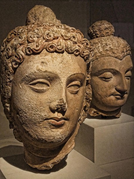
Gandhara Buddha
The Buddha was worshipped through these sculptural representations which had a distinct style associated with them that remained largely constant with some changes owing to skill or craft being seen. The Buddha is always depicted in simple monastic robes, with his hair tied in a bun known as the Ushnisha and the expression on his face is almost always one of content. Whereas originally these sculptures were painted in bright colors, now only the plaster or stone remains and barely a handful of items have been found with their original colors intact. Various cult images of the Buddha were made for the varying cults in the region all of which had their own distinct identifying features namely the Laksanas (divine marks), Mudras (hand gestures) and various kinds of robes.
Whatever the case was, Buddha always had the central role in these pieces and can be immediately identified by the halo and his simple attire. Many mythological figures are also seen as a part of these scenes along with couples, gods, demigods, celestials, princes, queens, male guards, female guards, musicians, royal chaplains, soldiers and also common people. More so, Gandharan art recreates these scenes in such detail that architectural elements and items of everyday use such as beds and vases etc. can be clearly seen in them and also give a glimpse into the building culture of antiquity. Gandharan art can thus provide us with an insight not only one aspect of the ancient life of the region but also of the entirety of the ancient buddhist daily life.
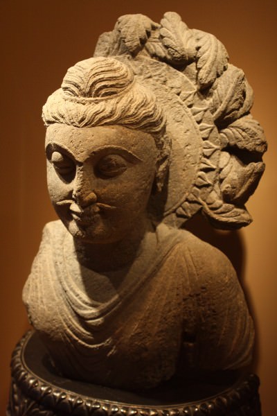
One of the most enduring elements of Gandharan art besides the Buddha is the Bodhisattva, which is essentially the state of the Buddha before he attained his enlightenment. Multiple Bodhisattvas from the various previous lives of the Buddha are depicted in Gandharan art with Avalokatishvara, Matrya, Padmapani and Manjsuri being prominent. Compared to the austerity of the Buddha images, the Bodhisattva sculptures and images depict a high degree of luxury with many variations on the various elements such as jewelry, headdress, loincloth, sandals and so on and the various incarnations of the Bodhisattva are recognisable from their clothing and postures, mostly of the hands in the seven mudras.
GANDHARAN ARCHITECTURE
Much can be said about the architectural tradition of Gandhara but the most prominent and unique characteristic of it was the proliferation of stupas and other associated religious establishments such as monasteries which formed the core of the regional identity for nearly 1000 years.
The Stupas were built mainly for the reverence of the remains of Buddhist masters and the most important ones held the remains of the Buddha himself. Besides the Buddha, monks of high stature were also venerated by having stupas built for them and these edifices also marked the places where certain legendary events related to the various lives of the Buddha were said to have occured. The proliferation of stupas across India is said to have been the hallmark of Asoka's rule who reinterred the ashes of the Buddha in multiple stupas all across his kingdom.
Even though it was mainly an architectural feat, the stupa nonetheless was a vessel for the display and worship of the prolific Gandharan art, encompassing sculptures, reliefs, paintings and other highly decorated elements that encased the structure and added immensely to not just its beauty but its veneration as a religious site. These images stood against walls, in courts, inside niches and chapels and stuccos adorned the walls of the stupa courts and monasteries.
Stupas were initially built with circular bases and were of modest size, but as the cult of the Buddha grew in importance in the region, these centers of worship were elaborately designed and adorned to boost the stature of the religion and to attract more worshippers. The original stupas at Kunala and Dharmarajika were small affairs which were later on expanded to grand proportions by rulers such as Asoka and Kanishka.

Stupa - Labelled Isometric View
The stupa was the main center of worship and in support it had the monastery, a structure with its own fully contained living area for monks. The monastery or Sangharama became a huge part of the Buddhist tradition and over time came to be its own self-sustaining unit, with lands for growing crops and wealth showered on them by lay people and royalty alike for their blessings. In its final form the monastery had some defined elements which suited its basic functions and these were:
- • Refrectory/Service Hall: Upatthana-sala
- • Kitchen: Aggi-sala
- • Cloistered Promenade: Chankamana-sala (for walking/exercise)
- • Bathroom: Jantaghara next to the central water tank
- • Store room: Kotthaka
- • Medical and general storage: Kappiya-kuti
These buildings were usually rendered in mud plaster and this was then painted over either completely or like in some cases (as in the monastery of Jina Wali Dheri in Taxila) scenes of buddha's life.

Buddhist Monastery Plan (Gandharan)
Aside from these religious buildings there was of course civic architecture as well which varied and changed with respect to the cultural prevalent in the region. Cities ranged from freely-planned organic settlements such as Bhir to the more rigid and planned out settlements like Sirsukh, with the city of Sirkap somewhere in between in terms of planning and layout.
The older cities tend to be more organically laid out while the newer ones seem to be very directly inspired by the Greek Hippodamian plan which surfaces later on in the 1st cent BCE. Shops, promenades, palaces, temples, sundials, hovels, huts, villas, insulae, pavillions, streets, roads, watchtowers, gates and fortification walls, all form part of the urban fabric which is true of most ancient cities as well.
Although the religious landscape was dominated by the Buddhist faith, there has is nonetheless ample evidence of other faiths intermingling and thriving in the social fabric such as Jainism, Zoroastrianism and early Hinduism amongst the various other cults. The temple at Jandial is said to be Zoroastrian in nature whereas a Jain temple and a temple of the Sun is in evidence on the main street of Sirkap city along with various stupas.
One of the most well known remains is the Double Headed Eagle stupa in Sirkap which contains its namesake motif of the double-headed eagle affixed on three different type of decorative arches namely the classical greek, persian and indian style of arch. This shows the degree of intermixing of cultures in the region which we can deduce from the archaeological remains.

Double-Headed Eagle Stupa
CONCLUSION
As we can see, daily life in the cities of Gandhara was very diverse and due to its location at a crossroads near to the Indus River, it constantly saw invaders, traders, pilgrims, monks and every other type of traveller cross through its lands. Westwards from India or Eastwards from Persia, the route through the region of Gandhara made it the center of every traveller's route.This is the same route through which Islam entered the region and probably struck the final nail in the coffin of Buddhism in the area. In fact the same route would be used for centuries even after Gandhara collapsed until the coming of the voyages of discovery and the prominence of naval travel via sea routes.
The riches of Gandhara, although well known to treasure hunters for centuries, would not be discovered again for over 2000 years until the era of British Colonial rule in the Indian Subcontinent, where the artistic traditions of this lost civilization were rediscovered and consequently researched and bought to light in the late 19th and throughout the 20th centuries CE, the study of which continues to this day.
LICENSE:
Article based on information obtained from these sources:with permission from the Website Ancient History Encyclopedia
Content is available under License Creative Commons: Attribution-NonCommercial-ShareAlike 3.0 Unported. CC-BY-NC-SA License